|
|
|
Making Development Happen: Implementing the Adams Dairy Parkway Corridor Plan |
. |
|
Francis E. Owens, C.E.D.
|
Author Info |
In late 1990, the City of Blue Springs adopted an ambitious plan to transform 1,800 acres on the eastern gateway to the Kansas City metropolitan area into a high quality multi-use development opportunity. The plan created in collaboration with HNTB Architects, Engineers and Planners, follows a unique, "City as Entrepreneur" approach whereby City officials have helped start and guide development through significant investments in transportation infrastructure, a golf course and lake amenity, and the adoption of development quality ordinances and guidelines. In the eight years since adoption, more than $37 million of public and private investment have been made in support of the Adams Dairy Parkway Corridor Plan.
The Adams Dairy Parkway Corridor Plan was the result of a decision by the City to fund and construct a new north-south arterial road to open up new land for development and serve the transportation needs at the eastern edge of Blue Springs, Missouri. Blue Springs, a community of approximately 40,000, lies at the eastern edge of the Kansas City Metropolitan Area and is the eastern gateway to the region. The community is one of the fastest growing cities in the metro area. The majority of this growth had been from residential development through the 1980's. City leaders believed a plan was needed to help diversify the tax base with more commercial and employment development. The largest remaining undeveloped tract of ground lie to the east of the city.
|
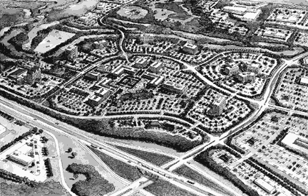
Click on Figure to view a large version. Figure 1 Rendering of Proposed Mixed-Use Development Center |
Extend the value and benefits of public investment in the Parkway facility to the largest development area possible,
Create opportunities for synergy, compatibility and support between individual land development efforts to enhance overall development quality and potential, and
Ensure a level of development quality that protected the value of public and private investment as the corridor developed over time.
The consulting planning firm of HNTB Architects, Engineers, Planners was hired by the City to work with the City in the development of land use concepts, a recommended development program, proactive marketing materials, and an implementation tool to manage development quality. The resulting amendment to the City's Comprehensive Plan was adopted in the Fall of 1990 and has since been amended slightly by City Staff in 1997.
Click on Figure to view a large version.
Figure 2: Adams Dairy Parkway Corridor Plan |
The current Plan, illustrated in Figure 2 to the right, includes construction of a north/south parkway facility (to the left of the drawing), a new interchange with I-70, a new golf course (in the lower center of the drawing), a lake amenity (in the upper center of the drawing) and areas for service and office development surrounding the lake and golf course with commercial, residential and industrial development located in appropriate locations in the area. The following pages chronicle the story of activities and perseverance that have resulted in the achievement of significant implementation of the plan and vision in less than ten years time from adoption. |
Funding for the Parkway project came from three major sources, Federal Highway funds of $1.5 million, state directed ISTEA funds of $800,000 and a voter approved local injection of $3.6 million. An additional local contribution of $400,000 was contributed to the project for landscaping and other aesthetic improvements.
Design plans which called for a four lane restricted access parkway, bike paths, sidewalks, landscape features, as well as pedestrian tunnels under the on and off ramps of the north outer road, were prepared and delivered to the appropriate agencies for review. Construction of the Parkway and supporting infrastructure began in December of l992 and continued until its grand opening during the month of November, l994.
It was with this backdrop that the process of beginning to capitalize on the City's investment and create an economic return began in earnest.
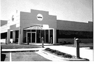
Figure 3: Haldex Facility |
Early in the Spring of 1992, Haldex, a subsidiary of a Swedish manufacturer of self adjusting brakes and last major company to locate in the community, celebrated the tenth anniversary of its location in Blue Springs. Company officials gathered from around the world to mark this event. During a tour of the facility, Mayor Greg Grounds, at the urging of local plant officials, approached the Swedish president of the company and asked for some time to share our vision of the Parkway and to tour potential sites. Dutifully impressed with the Plan and our enthusiasm, the president suggested that if the City could come up with an attractive proposal; they would take it under consideration. After ten years, the plant was becoming overcrowded and plans for growth could not easily be accommodated on site. This chance opportunity paved the way for several meetings that led to the submission of a proposal from the City, offering to assist the company in locating a new site in the Adams Dairy Parkway Corridor. After much discussion, a preliminary site was selected by the company and letter of intent was secured stating their interest. City staff rejoiced.
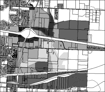
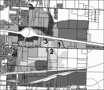
Click on Figure to view a large version. Figure 4: Illustration of Specific Project Locations |
The haze of victory soon faded as the limitations of the site came to light. The property was located at the far east end of the Parkway Corridor (See Figure 4, Number 1 for location). According to the plan, access to the site would be from a planned outer road and have excellent Interstate visibility. In reality, there was no road, no utilities, the City didn't own the land and the only way to access the site required crossing a county bridge that subsequently failed inspection. Additional requests for tax abatement and the requirement that the City buy the existing building from the company, further complicated the matter. In the heat of passion known only to those in the final stages of on economic development "hunt"; the City agreed to provide the necessary improvements to allow the project to proceed. |
The first step in the process of convincing both the company and our elected officials that this project would work, was to acquire the selected 32 acre site. Our investigation into ownership showed that the property, a defunct but platted industrial park, had been foreclosed on by a bank. The bank was willing to sell the property to the City but in closer examination, a .4 acre portion of the tract had an outstanding lien still pending. The former owner, now in prison on federal weapons charges, had given the lot to his mother to repay a personal loan. After much dialogue with the bank and a payment to the mother to release her ownership claim, the City secured the property. We were now, "In for a dime, in for a dollar".
The second stage of the effort required providing utilities and access to the site. A request for assistance was made by the City to the Missouri Department of Economic Development under the Community Development Block Grant Program. The basis of the City's $500,000 request was driven by Haldex's creation of both new capital investment ($4 million)and job creation (l00 new jobs). While ultimately approved, this application, and the prerequisite public hearings came during the final days of an election for City Council. One challenger, objecting to the confidentiality required by the "but for" clause inherent in the federal grant application, accused the City of smoke filled, back room politics for not revealing Haldex's intent. The incumbent subsequently denounced his opponent for potentially jeopardizing our effort to secure the grant. The incumbent won.
Acquiring the land and the funds to provide utility extensions to the project left the City with the problem of accessing the site. The proposed outer road that would connect the property to the new interchange was at least a year off. The primary access to the site was over an old bridge on a two lane, unimproved county road. The bridge, declared unsafe for the loads required to service Haldex, would have cost over $350,000 to repair. This necessitated evaluating alternative routes to the site. When no practical alternative could be identified, a decision was made to buy and construct a "bailey bridge" over the existing deck of the old structure. A "bailey bridge" is a portable, readily assembled metal frame bridge that is often used by the military to quickly span wide spaces. Several weeks and $50,000 later, the bridge arrived on large pallets complete with instructions and a construction supervisor. With the bridge in place, traffic was able to move to the plant and plans for the construction of the outer road continued on schedule.
The issue of the City buying the former building from the company was at best, a thorny political issue. The parent company had expressed concern that they did not want to be in the real estate business. (Interestingly, neither did the City.) Several company buildings were sitting empty and were being considered as potential sites for the expanded plant. To offset this concern and firmly lock the plant's location, the City agreed to purchase the building from the company for "book value". A price of $920,000 was established and the City assumed ownership of the building. On the market for 7 months, the building was sold to a playing card manufacturer who brought 200 new jobs to the community. The sale price was $945,000, almost enough to cover the City's lost interest expense and regain our original investment.
Tax abatement was granted through a Missouri state statue that allows local communities to "blight" properties and provide real property tax abatements to encourage development. A redevelopment corporation was set up, using City staff and the president of Haldex as the board of directors. The arrangement was maintained until project completion, at which time City staff resigned from the corporation and were replaced by company officials.
The end result of this effort included the creation of 350 new jobs, the retention and attraction of two industries, a $500,000 grant from the State, over $100,000 in net new taxes and a new found sense of achievement for the community.
The proposed golf course included in the Adams Dairy Parkway Corridor Plan was an attempt to differentiate the Parkway Corridor from other major planning efforts in the Metropolitan area. Anchoring a business park with an upscale daily fee golf course would create an image that was deemed to be attractive to outside business interests as well as appealing to our citizenry and their perception of the community. This aspect of the plan was also thought to be the most unlikely to occur by skeptics and pundits. Initial public response to the proposed course was enthusiastic, but as time passed, doubts grew both from within and outside the City's ranks. The major concern expressed regarded the magnitude of the effort.
In June l992, a preliminary feasibility study was commissioned by the City to determine the potential demand for such a course and in turn, the cost to construct and operate a course. National Golf Foundation, working with a turn key development team selected by the City, provided a favorable report on the demand for such a course and outlined both estimated construction and operational expenses. A decision was made to begin the project and a letter of intent was executed between the City and the private developer authorizing the group to proceed. Soon after, the development partnership unexpectedly failed. The City was left with no strategy or recourse.
During this time, public opinion in support of the course began to sway. Local opponents questioned the validity of the original feasibility study and of more concern, the City's ability to operate the course without considerable public subsidy. Doubt gripped the City's leadership and discussions turned increasingly skeptical. The golf course had become the first true test of the City's ability to continue with the Plan.
Discussions soon centered around what strategy could best be used to proceed with the project. A decision was made by the City Council to commission a second feasibility study; a study to be completed by a different group without access to the original report. THK, a Denver based engineering firm, was selected and work on a second feasibility study began.
Wishing to minimize up front land acquisition costs as much as possible, the City decided to approach the existing land owners on the basis of the potential increase in land values that would result from donating a portion of their property to the City to construct the course. The process of meeting with all the property owners, with offers and counter offers, took approximately four months to complete. At the end of that time, only one of the l8 property owners expressed a willingness to donate land, and then only in trade for a city funded utility line relocation. Local real estate agents contributed to our disappointment by creating a "bidding war" as to which agent could get the owners the most money. It became apparent that our efforts to convince the property owners of the potential increase in value associated with the proposed course, only galvanized their existing high opinion of their land's worth and a new course of action was wanting.
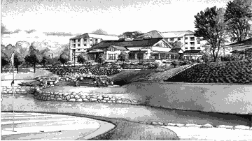
Figure 5: Rendering of Golf Clubhouse Under Construction |
Using the findings of the second study, the City formulated and approved a total budget for the proposed course. Revenue projections and proposed operational expenses were examined and a "not to exceed amount" for land acquisition and construction was approved by the City Council. A negotiating team, led by the Mayor, approached all l8 land owners with a simple message, "This is all we've got to spend. Will you sell?". This setting of the budget did two things to prompt the owners to finally sell or trade the land necessary for the course. First, it identified the limits of what the City would pay, putting a cap on speculation. Second, it gave the property owners a sense of parity with other owners so no one would benefit at the expense or gain of others. By July of l995, all 225 acres necessary for the course were assembled and construction began. |
The Adams Pointe Golf Club, funded by the city using golf course revenue bonds, cost approximately $8 million to construct and will open in May of l998.
Often overlooked in light of the higher profile projects the City was accomplishing, "the lake" prompted the greatest amount of controversy and ultimately generated a year long development moratorium on the Parkway.
The lake was included in the Parkway plan to take advantage of an existing drainage basin and to serve as a large storm water detention feature for most of the northeast portion of the City. A side benefit was the ability to provide a reliable irrigation source for the golf course during most of the year. Impacting only a handful of property owners, this project was largely put on the back burner during the first four years of the plan. Engineering and construction of the dam was accomplished in the same construction phase as the intersection and off ramps for the Parkway. The top of the dam became the base of the proposed outer road and little activity was pursued after completion of the road. This was largely due to the cost associated with infrastructure improvements necessary to flood the area and little economic return other than water for irrigating the golf course. Probably the most aesthetic aspect of the parkway, the lake generated only passing interest due to no perceived urgency for completion.
A home builder submitted a proposed plat that would provide for a several tier housing subdivision on the west side of the proposed lake. The proposal was in keeping with the Comprehensive Plan as well as the Parkway Corridor study. The most prominent feature of the proposal was the creation of an "executive" housing development that would provide direct lake frontage for the proposed homes. This effort also included a large number of smaller, higher density dwellings that would be constructed first. The idea was to create a revenue stream from the sale of the smaller homes that would allow for the eventual development of "executive" homes.
Members of the Planning and Zoning Commission evaluated the application in light of the Comprehensive Plan and the Parkway study. Public attention was drawn to the proposal due to an ongoing concern regarding a perceived lack of "upscale" housing in the community. Lakefront villas and other amenities appealed to a number of groups in the community; especially the real estate community. Controversy started brewing as the proposal made its way through the planning process.
Several members of the City Council began to question the validity of expending public dollars to in effect, "subsidize" an upscale housing development. Housing was considered by some to be a "quick fix", adding little to the overall tax base. This fact, coupled with the additional potential of chilling investment in commercial development, became the leading opposition argument. The City Council requested that the Planning and Zoning Commission reconsider the application in light of their concerns. The resulting split in philosophies soon began to play itself out in the local media. Sensing an impasse, the City Council voted to institute a moratorium on all development in the Parkway. The thought was to revisit the underlying premise of the Parkway plan and determine if the plan was still in step with both the economic and political leanings of the community. Several work sessions were held by the Planning and Zoning Commission as a group; as well as with the City Council. Outside experts were brought in to advise each group as to the merits of residential and commercial development. The issue was further compounded by a television feature that linked the home builder pushing the proposal to substandard construction practices. Watching homes slide down a hill in nearby Overland Park, Kansas on 20/20 had a definite impact on the discussions. After nearly a year, several resignations from the Planning Commission, and somewhat strained relations between several Council members, the issue was resolved. The area of the plan that had been originally slated for housing was amended to a Service and Office classification. The decision to wait for commercial and industrial development had been made.
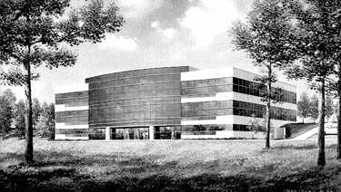 Figure 6: Artist's Rendering of Harmon Industry Facilities Under Construction |
The moratorium, while tantamount to putting a "closed" sign on Parkway development, was generally applauded by the development and business community. During this time, overtures were made to a local company that was experiencing tremendous growth. Harmon Industries, a leading company in transportation technology, had its headquarters located in the City since the early eighties. The real growth of the company necessitated a consolidation of administrative offices and the Parkway seemed, at least to the City, to be an ideal location. A proposal to work with the company in finding a new location on the Parkway was submitted. Property immediately north of the golf course club house was identified by Harmon as their preferred site. The property, situated on one of the highest points in the Parkway and highly visible from the interstate, overlooks the driving range and first fairway of the course. The City, using the same development corporation procedure as in the Haldex deal, acquired the 10.9 acre property from the existing land owner for $1 million ($2.10 per square foot). Absent any state sponsored programs that would assist in the location of a headquarters facility, the City once again used tax abatement as an inducement to seal the deal. The City, relying on its previous experience with Haldex, did however, change a significant element of the proposal. The land, acquired for $1 million, would not be sold to the company, but rather leased over a l5 year period. The terms of the lease were sufficient to repay the City's initial purchase price and generate a 5.75% return on our investment. The company's lease of nearly 4 acres paid for the entire 10.9 acre tract.
The end result of this effort included the retention of a world headquarters location, the construction of a 45,000 square foot/$4 million dollar facility and City ownership of approximately 7 acres of highly visible interstate frontage. Once again, it was time to start hunting.
Early in the negotiations with Harmon, it became clear that the land made available from the Harmon lease agreement would be the ideal location for a proposed hotel conference center called for in the Parkway Plan. By mid summer of l996 the City Council authorized the commissioning of a feasibility study to determine the viability of such an effort. Horwath Hospitality was selected to provide the study. This study became the basis of a request for proposal that, with Horwath's assistance, was sent to select hotel groups and developers throughout the country. This request for proposal generated four responses with varying degrees of interest. The field was narrowed to one strong candidate and negotiations began.
The development group initially offered to construct a l50 room hotel with an attached 12,000 square foot conference center on the 7 acre tract. In exchange, the group requested that the City provide free land, tax abatement for 25 years, all utility extensions and a portion of the sales tax generated by the project. The request was due, in large part, to the developer's concern regarding the start up costs associated with the project and long term losses anticipated with the conference center. The City found the proposal unacceptable.
The City, using the same experiences that allowed the golf course project to proceed, analyzed all aspects of the effort and made a counter proposal. The City would fund the construction of the conference facility (including a video conferencing center) and lease the ground for the hotel, if the developer would increase the size of the project to over 200 rooms. The funding for the conference center would come from a City sponsored lodging tax; a tax that would require a city wide vote. The combined estimated project cost of this effort, if successful, will be over $l8 million dollars. The developer and the city are now awaiting the result of this vote.
The City Council adopted the Adams Dairy Parkway Corridor study in November, l990. The Parkway road facility officially opened in November of l994.
In the eight years since the adoption of the plan, many changes have occurred both to the physical landscape of the area, as well as to the plan itself. What did not change was the ongoing commitment of the community and its leadership to the overall goals of the Parkway plan.
The City of Blue Springs is unique. Our mayor and city manager have led the community since the inception of the plan. Every department head involved in the planning and implementation of the various elements of the plan have been on board since late l992. Every City Council member elected since l990 has made support of the Parkway their main campaign platform. This collective commitment, both by City staff and elected officials, has created over $37 million dollars in investment in the Parkway since l993. The anticipated hotel conference center and related improvements will push this amount to over $54 million dollars.
The Adams Dairy Parkway Corridor represents only a part of the effort put forth by the City and its leadership to continually re-create our community. Nearly one in every five persons now living in the City of Blue Springs did not live here at the inception of the Plan in l990. The continued commitment to quality growth and development we now enjoy is in large part a product of our leadership's ability to convey the message: "We can. We will.".
Francis E. Owens, C.E.D.
Economic Development Director
City of Blue Springs, Missouri