Planner's Technology Tools For Citizen Participation
 |
 |
 |
 |
|||||
Session:Technology Tools For Citizen Participation (March 12, 4:00 pm)
|
|||||||||||||||||||||||||||
|
Planner's Technology Tools For Citizen Participation
|
|
||||||||||||||||||||||||||
Session:Technology Tools For Citizen Participation (March 12, 4:00 pm) |
|||||||||||||||||||||||||||
|
Abstract: This article is a summary of the tools discussed at the session, "Technology Tools For Citizen Participation" at the American Planning Association’s national conference in New Orleans in March, 2001.Thanks to the APA Information Technology Division for sponsoring the panel. The article was edited by Chris Steins with contributions from each panelist.
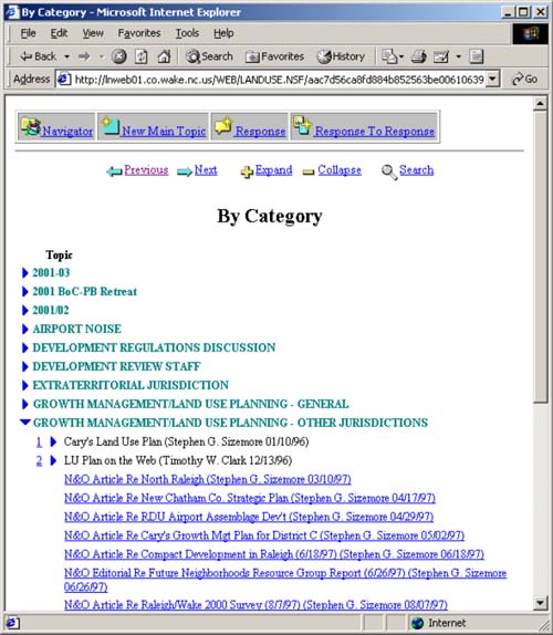
As the Internet reshapes we communicate and distribute information, planners have the opportunity to use Web technologies to expand and enhance access for public participation in urban planning and urban design. Using An Intranet — Wake County, North CarolinaTim Clark, AICP, Senior Planner for the Wake County (NC) Planning Department, discussed how the department is using an Intranet to engage citizens in planning decisions. An Intranet is a website that is focused internally, and access is typically limited to authorized users (hence the name Intranet, versus Internet). The Wake County Planning website has evolved using the Lotus Notes and Domino software products. These products allow Wake County planners to easily create, catalog, and share nearly all of their work electronically on an Intranet website. Documents that are intended for the public are made available on Wake County’s public Internet website. Figure: Wake County Intranet
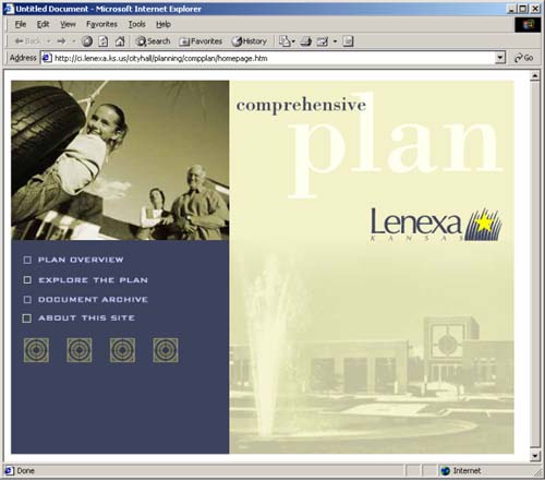
Wake County’s system features an easy-to-use interface that does not require technical skills to publish materials on the Intranet. This has allowed the department to be more efficient, has eliminated duplication of effort, and has greatly expanded the ability of non-technical users to contribute information to the website. General inquiries, plans and ordinance updates, and information about pending development requests are available through the website. Online Comprehensive Plan — Lenexa, Kansas Bill Meyer, Planning and Development Director for the City of Lenexa (KS) discussed the City’s decision to make the Internet the primary publishing vehicle for its updated Comprehensive Plan and how the plan fits into the City’s and the department’s overall web strategies. Figure: City of Lexena Comprehensive Plan
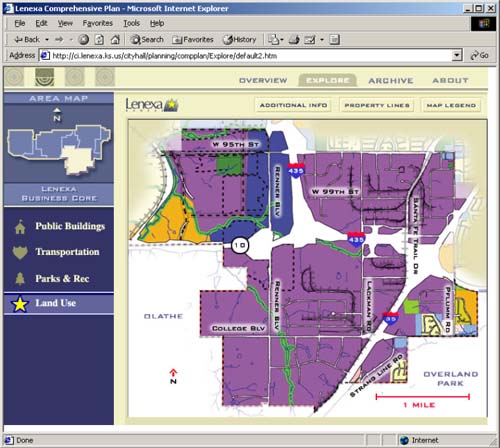
In order to make the plan more accessible to citizens, a friendlier, shorter version of the comprehensive plan is available on the Planning Department’s website as a series of linked web pages. Those who are interested can also access the full detail of the plan, including detailed maps and back-up reports in Adobe’s PDF format. A highly interactive section of the plan, called "Explore the Plan" allows the user to graphically explore the city by area and by topics, such as land use, parks and recreation, public buildings, and transportation. This section of the plan uses Macromedia’s Shockwave plug-in to enhance the user’s experience. The department’s experience and the feedback from users has been positive. Citizens who would not have requested a printed copy of the plan or come to city hall to review it are now reviewing the plan online at their leisure. Online delivery has also saved the city money in copying and mailing costs. The online plan has enhanced the city’s ability to receive comments on the plan for a more diverse group. Figure: Lenexa Comprehensive Plan: Exploring
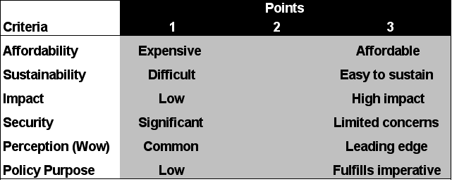
Tools For Citizen EngagementChristopher Steins, CEO of Urban Insight, discussed a matrix for evaluating technology tools, and presented four popular technologies for engaging citizen in the planning process: web mapping, email newsletters, handheld devices, and virtual reality. The evaluation matrix considers each technology tool against six criteria (Table 1), and assigns between one and three points. Those technologies that score highest are those that will most likely succeed in engaging citizens in the planning process.
Table 1: Technology Evaluation Matrix
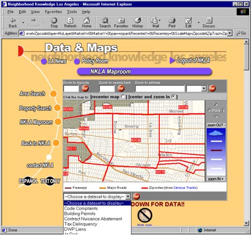
Neighborhood Knowledge, Los Angeles (NKLA) was developed by the Advanced Policy Institute at the University of California, Los Angeles, and is an excellent example of the use of web mapping to empower and engage citizens. NKLA is based on the premise that sometime before neighborhoods and buildings decay physically, they begin to decay financially. NKLA helps prevent neighborhood deteriorating by identifying these financial signs through the use of a web-based, user-friendly mapping system that allows community groups and businesses to look a complex data such as tax delinquencies, building code complaints, and other indicators for any zip code, census tract, or council district in Los Angeles. Figure: NKLA web mapping
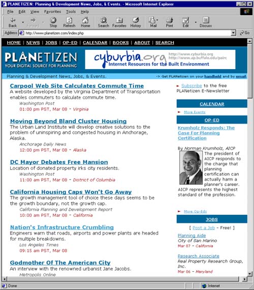
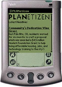
PLANetizen is a free Web-based information exchange for the urban planning community featuring daily news, commentary, jobs and events. PLANetizen news is delivered to subscribers via handheld devices (such as Palms, Handspring Visors, or Windows CE devices) and via a weekly email newsletter, as well as on the website. These tools provide an affordable way to "push" timely information out to users. Users can receive daily updates from PLANetizen on their handheld device every time they synchronize their handheld device to their computer. Both the use of the handheld device, and the email newsletter hold great promise as methods to quickly and affordably communicate with a large number of constituents. Figure 6: PLANetizen website
The use of virtual reality is rapidly emerging a an excellent technology to create a sense of "place." Using Apple’s QuickTime VR technology and a digital camera, planners can quickly assemble a 360-degree "virtual tour" of a place. This can be particularly useful in meetings where stakeholders have different perceptions of a common place, such as a building or street corner. Figure: PLANetizen news headlines on a Palm handheld
Websites To Visit Wake County, North Carolina Planning Department http://web.co.wake.nc.us/Planning/ City Of Lenexa, Kansas Online Comprehensive Plan http://www.ci.lenexa.ks.us/cityhall/planning/compplan/ PLANetizen: Your Digital Source for Planning Neighborhood Knowledge, Los Angeles Urban Insight
Author and Copyright InformationCopyright 2001 by Author Panelists / Contacts Bill Meyer, Planning and Development Director Timothy W. Clark, AICP, Senior Planner Christopher Steins, Chief Executive Officer Session Moderator Joseph Baker, Chair, Session Coordinator Mike Skowronek, AICP, GIS Coordinator |