|
There is an intense and growing interest in many areas of the country about how to mitigate urban sprawl. This interest is driven by the tax costs of serving sprawl, air-quality problems associated with increased car usage, the inconvenience and high costs of traffic congestion, and the conversion of open space. In addition, many communities are grappling with how to promote growth and renewal in regions suffering from economic decline or are recovering from some sort of natural disaster.
Advances in innovative modeling and visualization techniques are transforming the ways communities can use information to make local decisions. The U.S. Department of Energy, the U.S. Environmental Protection Agency, and are working with a handful of communities to establish locally based and controlled Regional Resource Centers equipped with a suite of decision-support tools. The concept of Regional Resource Centers emerged from a series of meetings and discussions with technicians, vendors, and community leaders.
Regional Resource Centers can improve both the process and outcomes
of the decisions making process and can help communities recognize
the value of integrating resource efficient strategies into the way they develop.
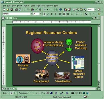
Each Regional Resource Center will be a place in which the local community can develop, assess, and visualize how it will grow. Equipped with both technical and non-technical decision support tools, these Centers will enable ordinary citizens to visualize and evaluate alternative growth scenarios and help integrate resource efficiency and sustainable design into community development strategies. These Regional Resource Centers will represent a combination of data, information, and computer, as well as, non-computer-based tools and services, within a structured framework that improves both the process and outcome of decision-making. They will serve as a testbed for the validation and demonstration of the wide range of planning and visualization tools developed at the federal, state, local and nonprofit levels.
The long-term aim is to equip hundreds of communities with the tools that will make it easier for those communities to visualize how they want to grow and what the consequences of their decisions are.
Connecting Local Community Issues with Federal Programs and Goals
Decision support tools can help bridge local and national objectives by enabling communities to incorporate a broader array of issues into their decision-making processes. For example, combining impact analysis with spatial mapping, visualization, and modeling tools, provides community planners with a much more comprehensive understanding of the links between smart growth, resource consumption, and environmental quality. Interactive tools that can automatically calculate the air and water pollution associated with different development choices, as well as concerns about public infrastructure costs and jobs creation can enable communities to make balanced decisions.
A good example is the city and county of San Diego. A few years ago, the San Diego metropolitan area used the DOE-sponsored community resource, PLAnning for Community Energy, Economic and Environmental Sustainability, (PLACE3S ) to analyze several regional development scenarios. San Diego found that the region could save $1.5 billion over its 15 year planning horizon by emphasizing energy efficiency in its development plan. The energy-efficient plan also would create 5,000 new jobs and prevent a half-million tons of air pollution. The county was so enthused that it created one of the nation's few county energy offices to work on capturing these benefits.
Communities that have expressed interest in establishing Resource Centers include Albuquerque, NM, Chattanooga, TN, Chicago, IL, Denver, CO, Martin County, FL, Saint Paul, MN, San Francisco, CA, Sarasota, FL, Sturgeon Bay, WI, and a collection of rural communities in North Carolina.
---
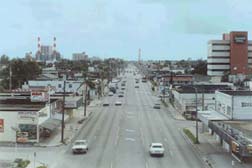
Existing Conditions
|
20 Year Build-Out with Existing Zoning
|
 |
 |
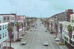
Twenty Year Build-Out with New Zoning
|
 |
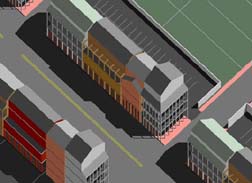 |
State-of-the-art planning tools involving spatial impact analysis, 3-D visualization, and policy modeling enable communities to make better development decisions.
For more information contact Ken Snyder, US Department of Energy – ken_snyder@nrel.gov or visit the toolkit section on our website at http://www.sustainable.doe.gov/.
Author and Copyright Information
Copyright 2001 by Author
Ken Snyder
Community Development Program Specialist
US Dept of Energy, Denver Regional Office
1617 Cole Blvd; MS 1721
Golden, CO 80401
(303)275-4819
fax (303)275-4830
|