Session: The Urban Village Code (March 14, 8:45am)
Abstract:Conventional zoning is often viewed as antithetical to New Urbanist principles of development. In Saint Paul, Minnesota, the concept of the compact, mixed use "urban village" is widely supported at many scales, from the city’s comprehensive plan to specific redevelopment plans for large sites, to small-scale infill guidelines for commercial nodes and transit corridors. However, the city’s segregated and hierarchical zoning districts have created unnecessary barriers to urban village development. Planners are now developing new zoning districts and guidelines that advance these principles, within the framework of the city’s conventional zoning ordinance.
CAN THIS ZONING CODE BE SAVED?
It is commonly stated in the literature of the New Urbanism that zoning and subdivision codes create major barriers to traditional neighborhood development and to development based on "smart growth" principles. A recent study of Illinois municipalities reported in New Urban News indicated that the vast majority of the zoning codes surveyed either prohibit compact, mixed-use development or make it extremely difficult. "Based on the available evidence, it seems clear that a prodigious overhaul of local laws will need to take place in order for the New Urbanism/smart growth to be implemented on a broad, nationwide scale.
When compared with the few complete New Urbanist codes in existence, conventional zoning is often held accountable for all the evils of conventional suburban development. It is criticized for being text-based rather than graphically-based, for emphasizing separation rather than mixing of uses, uniformity rather than diversity, and most of all for being needlessly cumbersome and complicated.
Planners recognize the truth in many of these stereotypes. Many of the zoning codes we work with are so old, and have been so heavily amended over the years, that they are now creaky Rube Goldberg-style contraptions, whirring and clanking through their paces, barely adequate to guide the simplest land developments, let along adapt to the New Urbanist paradigm.
So what’s a planner to do? Throwing out the old code and replacing it with a simple, graphic matrix is, unfortunately, neither politically feasible nor practical in most developed cities. The old rules are too deeply ingrained in local development practices to be easily traded in for an unknown quantity. Moreover, urban realities are simply too complex and messy to be guided by a single, elegant graphic matrix — unless you want to develop a different one for every neighborhood, block and building type in your city.
In response to this challenge, planners in Saint Paul are creating a simple and broadly applicable set of new zoning districts and design guidelines that will guide redevelopment and infill according to New Urbanist principles across a wide range of development sites within the city.
----
Figure 1: A view of Saint Paul from downstream – a park in the Dayton’s
Bluff neighborhood just east of downtown – showing barge traffic, the
Lowertown urban village in the foreground, and the State Capitol in the distance.
----
THE EVOLUTION OF THE URBAN VILLAGE CONCEPT IN SAINT PAUL
Beginning in the 1990s, policymakers, neighborhood advocates and developers began to develop an increasing awareness of the role of place-responsive urban design in sustaining and renewing the city’s downtown and its neighborhoods. This change is manifest in the 1997 policy plan for the city’s downtown and riverfront: the Saint Paul on the Mississippi Development Framework. The plan, prepared by a team led by Toronto consultant Ken Greenberg of the firm Urban Strategies, advanced a compelling vision: a series of interconnected mixed-use urban villages in and around downtown, nestled in the lush green of a reforested river valley.
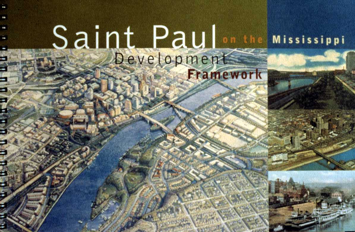
Figure 2: The cover of the Saint Paul on the Mississippi Development
Framework, with an image of the downtown and the river corridor that
has come to symbolize many of the city’s redevelopment efforts.
----
The framework plan set forth ten guiding principles for city building, which have since been incorporated in the city’s comprehensive plan:
Evoke a sense of place. Create a physical setting that says, "This is St. Paul."
Restore and establish the unique urban ecology, parts of the natural environment that have been lost over time due to development.
Invest in the public realm. Create a network of streets, sidewalks and parks that are safe, vibrant and pedestrian-friendly.
Broaden the mix of uses. Create urban villages where people live, work and play.
Improve connectivity between neighborhoods, downtown and the river.
Ensure that buildings support broader city building goals, with design that fits into their surroundings and helps make adjacent public spaces active.
Build on existing strengths: historic buildings, parks, tree-lined streets and the Mississippi River.
Preserve and enhance heritage resources: historic buildings and public spaces.
Provide a balanced network for movement. Design city streets to accommodate pedestrians, cars, buses, bikes, on-street parking, landscaping, lighting and signs.
Foster public safety. Increase the number of people in our public spaces.
Saint Paul mayor Norm Coleman has strongly supported the translation of these principles into design guidelines and streetscape improvements in the downtown core and along the river. A recent cover story in Landscape Architecture lists some half a dozen projects, from downtown streetscape improvements to new riverfront parks and the design of new downtown office buildings, that can be traced to the framework plan and principles.
The city’s Land Use Plan, adopted in 1999 as part of its comprehensive plan, elaborates on the theme of "neighborhoods as urban villages." The plan points out the similarities of New Urbanist communities and Saint Paul neighborhoods, and establishes a series of urban village principles, such as compactness, walkability, presence of schools, parks, commercial centers and civic institutions, and a broad range of housing types. The plan also states that "Saint Paul has a few large, cleared sites where new urban villages may be built. But it is even more important for the city to use traditional neighborhood development concepts for protecting and reinforcing the strengths of the city’s existing neighborhoods."
Today in Saint Paul, New Urbanist development principles are reasonably well understood by the mayor, by many City Council and Planning Commission members, and by many of those most involved in neighborhood organizations. In fact, there has been a kind of grass-roots call for urban village and New Urbanist development in recent years by people in neighborhood organizations. Many of them may not know the terminology of the New Urbanism, but they do know that there has been an erosion of development patterns and neighborhood institutions that help to create community, hold our neighborhoods together, and make them good places to live. For planners involved in zoning, that is both a challenge and an opportunity.
PHALEN VILLAGE REVITALIZATION: MIXED USE IN SPITE OF ZONING
Through the first half of the twentieth century, a series of cohesive neighborhoods formed a ring of urban villages around Downtown St. Paul. Early St. Paul neighborhoods such as Irvine Park (near the Upper Landing just upstream from Downtown St. Paul) and Lowertown (near the Lower Landing) were urban villages in every sense, with a mix of uses including residential, commercial, civic and open space uses in close proximity to one another, and a mix of housing types and sizes to accommodate households of varying sizes, ages and incomes. Through preservation efforts in recent years, Irvine Park has remained a highly desirable neighborhood, while the Lowertown area has been renewed with new housing, offices, a farmers market and artists’ studios.
As St. Paul grew up the hill and out across the prairie, a pattern of urban villages also developed along streetcar lines, such as the premier shopping street of Grand Avenue, and in neighborhoods such as St. Anthony Park. These continue to be among the city’s strongest neighborhoods.
This settlement pattern began to change, particularly after World War II. Neighborhoods along the river, such as the Upper Landing, were replaced with industrial uses such as grain elevators and scrap yards. In the North Quadrant area of downtown, a couple of churches are all that remain of the original urban village, and the area is now mostly surface parking lots serving downtown commuters.
Phalen Village, a post-war working-class neighborhood of predominantly small single-family homes on the city’s east side, offers an example of the detrimental effects of conventional development practices, and the challenge of reversing these trends.
Like many cities, Saint Paul began to build streets for cars rather than people, and shopping centers with large parking lots rather than neighborhood shops along transit streets. In 1960 a small lake was filled in and paved over for construction of Phalen Shopping Center. Nearby apartment buildings were also constructed in "superblocks" around large parking lots; in some cases it is their back doors that face the street. Intersections were specially designed so most cars did not have to stop, making them difficult for pedestrians to cross.
Phalen Center didn’t age well. By the early 1990s, about the time Allan began working with a neighborhood task force to figure out what to do with it, Phalen Center was rundown and underused. When he asked task force members what they wanted their neighborhood to be like in ten or twenty years, the typical answer was, "Well, ideally, a more compact, pedestrian- and neighborhood-oriented commercial area near the bus stops, with a mix of uses, you know, more like St. Anthony Park, Highland Village, and neighborhoods along Grand Avenue."
The task force decided it should make no small plans: that if all it did was rehabilitate some apartment buildings and spruce up the commercial area without changing the neighborhood’s basic structure, the same problems would eventually reoccur. A studio class of architecture and landscape architecture students from the University of Minnesota, along with neighborhood old-timers who grew up fishing and skinny-dipping in Ames Lake (which had been filled in for development of Phalen Center), suggested that the lake and area wetlands should be restored as a public open space system that would become an urban village commons and signature amenity. While some thought it was a little crazy, the idea really struck a chord in the neighborhood. The 1995 Phalen Village Small Area Plan boldly recommended transforming the Phalen Center area from a blighted asphalt wasteland into a mixed-use, transit- and pedestrian-oriented urban village.
When most of Phalen Center was torn down in 1998 (a remaining portion contains a grocery store), large voids were discovered under the building where fill over deep wetland soils had continued to settle. Ground water quickly filled the excavation and by the spring of 1999 Ames Lake had reappeared. It is not uncommon for wetlands to be filled in and paved over for construction of shopping centers, but as far as we know this is the first time a shopping center has been torn down for restoration of a wetland, reversing the typical scenario of "paving paradise and putting up a parking lot."
The implementation of the Phalen Village Plan made it clear that, when attempting to retrofit an urban village, the city’s zoning code is often more of a hindrance than a help.
The city restructured the street system to create a new commercial corner on Maryland Avenue (the neighborhood bus route) and a neighborhood drug store has been relocated from Phalen Center to the new corner. The parking lot was placed on the side rather than front of the building, but only after a lot of arm-twisting, not because of any zoning requirement.
New townhouses have also been constructed along Maryland Avenue, with tuck-under parking on the rear, front porches, and "home office" space facing Maryland that was designed for home occupations. This would have been a perfect place for live-work units with larger spaces for office or service uses, but the zoning code made that too difficult.
A new cooperative senior housing project will be constructed in the heart of Phalen Village this summer. Planners hope eventually to have first floor businesses facing the street, such as beauty and barber shops, a coffee shop, and other services that would be useful to the senior residents, but the zoning code also makes that difficult.
NEW REDEVELOPMENT OPPORTUNITIES
Several of the old urban village sites surrounding downtown that were lost to industrial development are now ready for redevelopment. The grain elevators and scrap yards have been cleared from the Upper Landing, where an arterial road has been relocated away from the riverfront and redesigned as a parkway. The new Science Museum of Minnesota overlooks the Upper Landing, and helps connect the site to the downtown. Redevelopment is just starting on the West Side Flats directly across the river from downtown, a site vacated by American Hoist and Derrick several years ago.
----
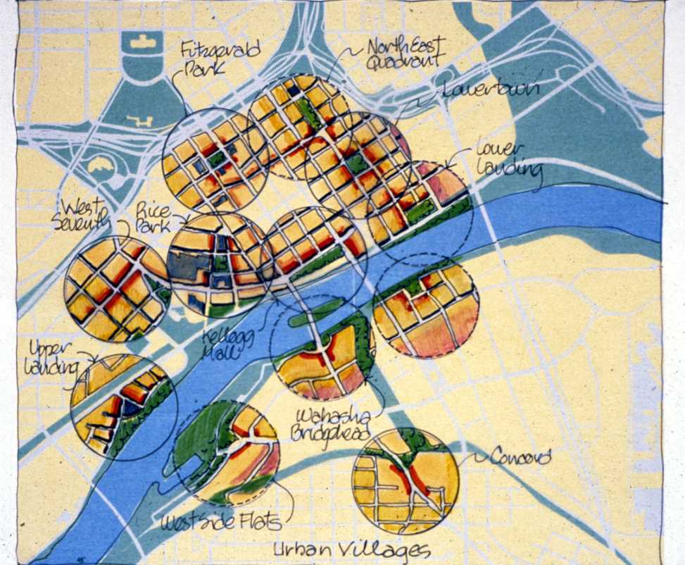
Figure 3: Illustration of existing and potential urban villages from
the Development Framework. The West Side Flats is located between
the two bridges on the lower bank.
----
In the North Quadrant area of downtown, redevelopment is already underway, based on a well-defined area plan and design guidelines. The first 300 housing units are being constructed around a new central park. The current B-5 Central Business / Service zoning allows all the uses the plan envisions on this urban village site. However, the B-5 zoning also allows many industrial and auto-oriented uses, and has almost no design or character standards.
Large old industrial sites outside of downtown are also attracting developer interest. One of these is a former "tank farm" on a bluff overlooking the Mississippi River about half way between downtown and the Minneapolis-St. Paul International Airport, on the Riverview Transit Corridor, where a high-speed busway is in the planning stages. According to a neighborhood plan, the site has the potential for about 600 housing units. Like other potential urban village sites outside of downtown, it has a significantly different neighborhood context — including adjacent single-family home — that any new development will need to respond to.
On each of these redevelopment sites the city has worked actively to develop master plans that respond to each site’s natural and cultural features and to the surrounding neighborhood context. As part of its strong commitment to good urban design, the city has established its own Design Center, a group of staff drawn from many city departments with an advisory board of neighborhood and business representatives and design professionals. The Design Center, with assistance from private consultants, usually prepares these master plans then works with selected developers to ensure that they are implemented.
In spite of all the proactive planning activities occurring in Saint Paul, the zoning code has continued to create unnecessary obstacles to urban village-style redevelopment. Therefore, planning staff sought and received a grant from the Twin Cities’ Metropolitan Council to develop zoning codes that would support the urban village approach.
Urban village zoning needs to work not only for large, vacant redevelopment sites, but also for incremental redevelopment of areas such as Phalen Village, as well as for smaller infill development along transit routes. These include sites along the University Avenue / Central Transit Corridor between downtown St. Paul and downtown Minneapolis, and sites along the Seventh Street / Riverview Transit Corridor through St. Paul to the Minneapolis-St. Paul International Airport and the Mall of America.
----
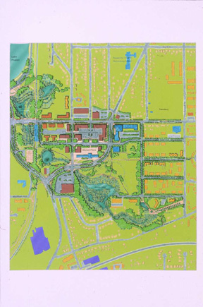
Figure 4: The Phalen Village Small Area Plan, showing
the restored Ames Lake and redesigned shopping center.
----
City planning and zoning staff have also defined some important functional objectives and constraints for urban village zoning:
It should provide more guidance for urban design and functional relationships for a greater mix of uses - without creating new administrative and plan review burdens for staff already stretched too thin.
New regulations need to function simply, clearly and efficiently, in a way that is easy for the public as well as zoning staff to use and understand. Urban village zoning districts cannot be so complex and onerous that property owners and developers avoid using them.
Urban village zoning needs to fit seamlessly into the existing zoning code, not make the zoning regulations more complex. It would not result in more overlay districts or layers of complexity and, ideally, should make the zoning regulations simpler and more elegant.
CHOOSING AN APPROACH
City planning staff, when issuing the request for proposals to undertake the project, recognized that the first step in the process was to determine the best approach for meeting these requirements. Would "urban village zoning" consist of a set of parallel standards that could replace the existing zoning ordinance in these locations? Or would it consist of a new zoning district, or perhaps a series of new districts, one for each redevelopment site? These options, and others, would need to be evaluated.
The consultant, working with a steering committee of planning staff, began by reviewing examples of New Urbanist or "TND" codes and regulations, in order to determine the range of potential approaches used by other cities. We discovered that these could be grouped into three main categories:
The "whole new system" approach: establishing a complete set of standards that parallel and largely replace the existing zoning ordinance. Primary examples include codes from Austin, Texas, and from Miami-Dade County, Florida. The comprehensive nature of these codes seemed to be outweighed by their length and complexity, and by the sheer amount of time needed to put them in place.
The place-based or plan-based approach: these ordinances reference a pre-existing neighborhood or small area plan, and include district-specific design standards. Examples we found including the "plan districts" of Portland, Oregon, and the "design incentive zones" of Milwaukee, Wisconin. The advantage of these districts is that they incorporate prior planning work and are highly responsive to site conditions. The disadvantage for Saint Paul is that they create multiple new districts, adding length and complexity to the zoning ordinance.
The mixed-use district approach: simply a conventional zoning district that allows a broad range of residential, commercial and institutional uses. Many cities have such districts, including many Twin Cities area suburbs. While easy to use and administer, these districts usually lack an important element of the true Traditional Neighborhood Development code: the recognition of neighborhoods as places with a center and an edge, where diversity is expressed through an internal gradation of uses and densities.
----
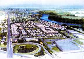
Figure 5: An illustration of a proposed development
at the River Bluff urban village site, a former petroleum
tank farm. West Seventh Street, on the left of the site,
is proposed as a transit corridor, and is where most
commercial development would be focused. An existing
industrial park is shown in the foreground, next to a freeway
ramp. Extensive site clean-up will be needed before
development can begin. Source: Brighton Development Corporation.
----
THE SAINT PAUL URBAN VILLAGE APPROACH
The staff steering committee and consultant ultimately chose an approach that draws upon, yet differs from, all the approaches surveyed. Three new districts are proposed, covering all types of urban village sites, from small commercial nodes in existing neighborhoods to the largest redevelopment sites. In tandem with the districts, a set of design guidelines will be developed to provide visual representations of the type of development the city has long been advocating.
It is intended that the new "TND" districts will occupy their own chapter in the zoning ordinance, between the residential districts and the predominantly commercial districts. Two of the new districts, provisionally named TND-1 and TND-2, are uncomplicated mixed-use districts, intended for small-scale infill development. TND-1 is intended as a transitional zone between existing or new commercial districts and largely residential neighborhoods. It will include varied-density residential, office and service uses, all in buildings of limited size. It is modeled on existing development patterns: small corner stores or the less-commercial segments of pedestrian-oriented shopping streets.
TND-2 is intended to be applicable in and around the city’s pedestrian and transit-oriented commercial nodes. It allows a broader range of commercial uses, still within relatively small buildings. Both these districts will include maximum as well as minimum setbacks, and will require that surface parking be located to the rear or side of buildings, and never in a corner location. A maximum as well as a minimum parking requirement will also be required — in fact, all parking above the minimum required by the code must be underground or within enclosed buildings.
The TND-3 district, intended for the handful of large redevelopment sites that remain in the city, is the most complex and "New Urbanist" of the districts, in the sense that it specifies the basic elements and characteristics of a traditional neighborhood and establishes a process for designing them. These basic elements are defined as:
A mixed residential area, consisting primarily of a variety of housing, with some office and service uses;
A mixed use "center," including the greatest concentration and diversity of commercial and civic uses, combined with higher-density housing;
An interconnected street system, including an internal hierarchy of streets designed for a variety of modes;
An open space system that works with the street system to create an internal structure for the site, which may include central squares, neighborhood parks, greenways and trails. At least 20 percent of the site must consist of open space, both public and private.
Although these elements are specified, the key aspect of the ordinance is that not all of them need to be part of the new development, if they are already present and accessible — generally within a quarter-mile walking distance. This concept, which we adapted from the model TND ordinance developed by the University of Wisconsin Extension Service, is key to fostering New Urbanist redevelopment in an existing urban setting. New development fits into an existing urban fabric, which may already contain many of the components of an authentic urban villages/traditional neighborhood. Thus, in an urban infill setting, the TND is in essence a mixed residential area. All else depends on its context.
The TND-3 district includes minimum densities and floor-area ratios for the mixed residential and mixed use area. A variety of housing and building types must be present, and each block should contain some diversity of land uses or building types. All lots must be located within a quarter mile of a new or existing commercial center, and 90 percent of all lots must be located within a quarter mile of new or existing parks and open space.
How would one develop a new TND-3 district? Whether or not a rezoning is needed, a master plan will be required in most cases. However, in many instances the city’s Design Center will prepare the master plan. The plan need not be extremely specific; rather it must delineate the street and open space systems, and indicate the general mix of land use at a block-by-block level. Sample building designs and a phasing plan would be provided. This master plan would be officially adopted by the City Council, but as a general guide — minor changes would be permitted with staff approval; major ones would require another Council approval. The goal is to make TND-3 a viable and attractive alternative to conventional zoning while ensuring that plans meet the district’s intent, but not to "set the bar" unreasonably high for the developer.
While the new zoning districts will contain certain design standards, it is equally important to provide examples of good urban design across the entire range of existing zoning districts. While Saint Paul has several sets of design guidelines for specific areas, such as the North Quadrant and West Side Flats, there are no general guidelines that the city can use in the site plan review process. Therefore, we are in the process of developing a set of broadly applicable citywide standards. These will primarily cover the relationship of a new building to its neighbors and to streets and public spaces. Topics such as the relationship of building to street, massing and scale, vertical and horizontal articulation of building facades, and position of entries will be covered in the guidelines. While the guidelines are intended to be advisory, it is hoped that they may ultimately be used across a wide range of commercial districts, ranging from urban to suburban in character.
Throughout the process of developing the new districts, staff and consultant have also been identifying opportunities for simplifying and streamlining the zoning ordinance as a whole. These include:
The option of eliminating the "Planned Development" district. Like many such "PUD" districts, this one includes a cumbersome process that is essentially without any design standards. Its results have frequently been unsatisfactory and the resulting development plans are difficult to amend later.
Elimination of various other redundant districts, such as an interim "Office-Service" district that the TND districts could ultimately replace.
General improvements to the organization of the zoning ordinance, such as organizing uses into tables for each category of districts, and grouping all conditions for conditional uses in a separate section.
PROJECT STATUS AND LESSONS LEARNED
The new ordinances and guidelines are currently in draft form, the result of many meetings of the staff working group and consultant. An initial round of public meetings in November 2000 indicated a fairly high degree of support for these changes among both neighborhood groups and business councils. As with all zoning changes, however, the real test will come with actual mapping of the new districts. Initially, city planners envision applying the TND districts only to the current redevelopment sites, while offering them as options that neighborhoods or developers may request for future rezoning opportunities elsewhere in the city.
One of the important lessons learned from this process is to build upon the strong urban design standards and practices the city has already established, and only change those regulations that must be changed. For example, the city’s Public Works Department has been ready to work with developers and accept a variety of "non-standard" street designs for new urban village locations. Each master plan developed to date has included its own internal street classification system. Therefore, it is not necessary to create new street design standards — the streets will end up being designed through the master planning process. Instead, the ordinance simply specifies that streets shall be interconnected and identifies their essential components, including sidewalk, planting strip, street trees and on-street parking.
Of course, each city’s standards and practices will differ, from the zoning code and subdivision regulations to the procedures for site plan review and the design of new streets. If planners wish to remove regulatory barriers to their own forms of traditional neighborhood development, these conditions must first be assessed, to determine where the major barriers are located. Each city’s staff capacity and level of commitment will also differ, and these factors will affect the nature and extent of the changes that can be undertaken. Saint Paul’s city administration already has a strong commitment to New Urbanist principles, while many cities have yet to reach consensus on, or even to begin exploring, these issues. Within these differing frameworks, however, we feel that there are many opportunities for "reforming" and retrofitting a conventional zoning ordinance in a developed city, with the goal of encouraging traditional neighborhood development.
Land Use Plan. The Saint Paul Comprehensive Plan. City of Saint Paul, Department of Planning and Economic Development, March 1999.
Martin, Frank Edgerton. Making the River Connection. Landscape Architecture, February 2001: 62-91.
Saint Paul on the Mississippi Development Framework. City of Saint Paul, June 1997.
Author and Copyright Information
Copyright 2001 by Authors
Suzanne Sutro Rhees, AICP, is a Senior Planner with URS/BRW in Minneapolis, and lead consultant for the Urban Village Code project. She has written numerous zoning ordinances and design guidelines, and is the author of the 1990 PAS Report Reinventing the Village: Planning, Zoning and Design Strategies. She can be reached by e-mail: suzanne_rhees@urscorp.com.
Allan L Torstenson, AICP, is Senior Planner for Zoning in the Saint Paul Department of Planning and Economic Development. He was project manager for the Phalen Village Small Area Plan and has worked extensively in the areas of neighborhood and transportation planning. He can be reached at: allan.torstenson@ci.stpaul.mn.us
Other information about Saint Paul can be obtained through the city’s web site: www.ci.stpaul.mn.us. Selected reports from the City’s Department of Planning and Economic Development can be accessed at www.stpaul.gov/depts/ped/