Addressing Livability When Reconstructing a Major Travel Corridor
 |
 |
 |
 |
|||||
Session:Mobility and Livability on Major Travel Corridors (March 14, 10:15am)
|
|||||||||||||||||||||||||||
|
Addressing Livability When Reconstructing a Major Travel Corridor
|
|
||||||||||||||||||||||||||
Session:Mobility and Livability on Major Travel Corridors (March 14, 10:15am) |
|||||||||||||||||||||||||||
INTRODUCTIONWith the continued decentralization of residential land use, traffic growth on radial corridors that connect the traditional business centers in the metropolitan core continues to increase. This paper examines the balance between responding to mobility needs while still considering livability and community values. The traditional role and function of major travel corridors is to move traffic. Traffic studies are completed and roadways designed with the intent of providing congestion-free traffic operation for a designated design year usually 20 years into the future. A second function of a travel corridor is to enhance land areas located adjacent to the roadway that can become a location for a major travel destination. A third function of a roadway, although one that is not often emphasized, is to become part of the built environment itself. Roadways build in the 1940s, 50s, and 60s had little thought given to the planning process and in particular the potential negative effects on adjacent land uses that could result from the construction of a freeway or major arterial. The primary objective was focused on addressing regional or statewide mobility issues. The roadway design function was the primary consideration. Today’s transportation process has evolved from this earlier roadway construction era. A number of transportation planning steps or processes are in place as needs are identified and roadway improvements designed. These steps are shown in Figure 1.
Corridor studies, whether part of a formal Major Investment Study (MIS) or not, long-range transportation plans and studies completed as part in compliance with the National Environmental Protection Act (NEPA) consider transportation needs. These needs often relate to the following considerations:
If federal funds are used, social and economic impacts of a proposed facility must be detailed as part of the environmental review process and are documented in either Environmental Impact Statements (EIS) or in Environmental Assessments (EA). The impacts considered in these studies often include:
The social and economic elements considered as part of the environmental process provide a clear opportunity to reflect community values into the decision to construct or reconstruct a roadway facility. There are some limitations due to the nature of the formal nature of the process. Some limitations of the formalized environmental planning process in some cases can be:
OPPORTUNITIES TO WORK WITHIN THE PLANNING PROCESSEven with the elevation of a number of major social and economic issues, a major transportation emphasis continues to be on improving mobility. The emphasis on adding roadway capacity has lessened to a degree as recent federal legislation such as the Intermodal Surface Transportation Efficiency Act (ISTEA) and the Transportation Equity Act for the 21st Century (TEA-21) have emphasized transportation management of existing facilities. Another major emphasis in recent years has been in the area of access management. This effort seeks to improve traffic flow and safety by reducing the number of traffic conflict points. The access management efforts seek to reverse the typical land development trends that result in pressures to add driveways, traffic signals and interchanges to major roadways leading to lower traffic capacity and resulting traffic congestion. Traffic calming, an approach that can be used to lower travel speeds, has a limited application to freeway and arterial facilities. Addressing livability issues should take place both in the planning and design phases of a project. In the planning phase, performance measures related to livability can be used to address these issues. A research project recently completed examines how to reflect goals, objectives and performance measures in the planning process. This project is NCHRP 446 Performance-based Transportation Planning1. NCHRP 446 describes how performance measures can be defined and then used to evaluate the effectiveness of a series of potential transportation alternatives. This approach provides a tool for transportation planners to use in determining the extent that specific transportation projects and programs reflect overall transportation goals and objectives. Performance measures reflecting community preferences regarding livability of transportation systems could be reflected in this type of planning approach. All of these activities are important to achieving a safe and efficient transportation system. However, the issue of "livability" is not always considered as a specific area of emphasis. One of the problems with studying livability is defining it. The concept of livability may also differ by community. Experience indicates that a good way to understand livability is to use a public input process from which community values can be learned, then reflect those values in the planning and design process itself. CAN FREEWAYS REFLECT LIVABLITY?Freeways are roadway facilities that are designed to provide high levels of mobility by moving large amounts of traffic at relatively high speeds. A freeway cross section will often be 300 feet or wider. Six, eight or even ten freeway lanes located in urban areas have changed the built environment and created barriers to community connections. Given the scale and impact of a freeway facility, can a freeway be designed in a way that could be considered livable? Some of the considerations which have been used in the design process are to:
AN EXAMPLE OF INTEGRATING LIVABILITY INTO THE DESIGN PROCESSUS-40 is an east-west route through St. Louis, Missouri and surrounding communities. A portion of US-40 was designated as I-64 and integrated into the interstate highway system. US-40 had been pieced together when two different major local roadways were connected in the 1930’s. Some of the existing roadway features date back to the 1940’s. There is little doubt in most commuter’s minds that improvements are needed to be made to I-64. A Major Investment Study completed for this corridor concluded that there were numerous traffic operation and congestion problems on I-64. However, the recommended solution was not to add capacity but to improve the freeway’s design standards. Roadway design problems identified were:
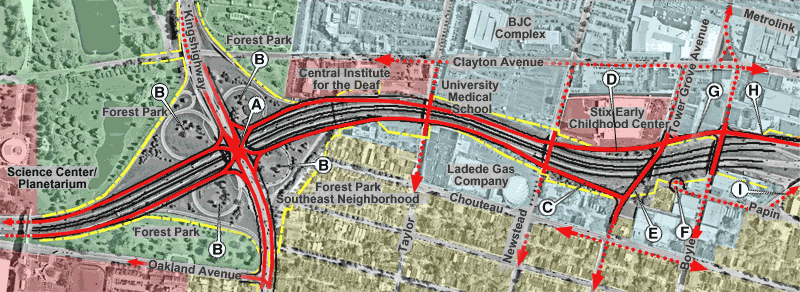
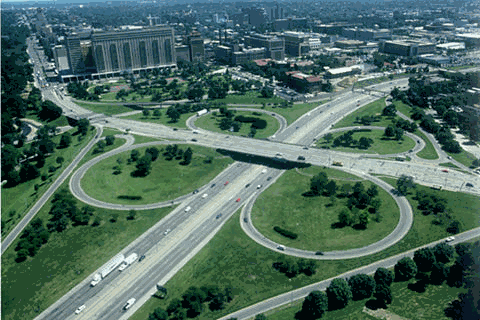
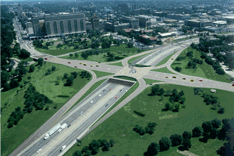
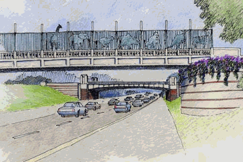
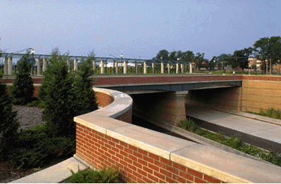
A project to re-design a 12-mile urban section of I-64 is being completed by HNTB Corporation. The project has provided an opportunity to incorporate public perceptions related to livability and to reflect them through urban design into the design process. The emphasis of this project has been to improve the vehicle transitions from the freeway to the adjacent neighborhoods and commercial areas. The public involvement process included identifying and conducting meetings with community leaders and with the public. A web site (thenewi64.org) was developed that allowed viewers to provide input on important considerations and to comment on specific design options. Newsletters and other printed information were also made available to the public. The freeway has been in place within the I-64 corridor for over 50 years. The effects of the freeway have long affected the character of the area. In many cases, the freeway has become a boundary that defines a neighborhood or a commercial area. Much of the corridor has developed to accommodate vehicle traffic. The community character differs along this 12-mile section of I-64. Three distinct subareas were identified and indicated as part of the overall study area. Some of the areas adjacent to I-64 contain important cultural features. One of these areas is a section of I-64 adjacent to Forest Park, former home of the 1904 Worlds Fair and current home of the St. Louis Zoo. Efforts to minimize visual impacts and to re-connect the communities located on each side of I-64 can be illustrated by potential improvements to the Kingshighway interchange. Here a substandard cloverleaf interchange may be replaced by a single point urban diamond. This improvement would reduce the land area dedicated for the transportation use and would replace the two ramp intersections with one intersection. While the single point interchange will remain as a barrier to pedestrian travel, it will provide for an improved transition from the freeway to the arterial roadway system that will improve access to adjacent commercial, medical and cultural facilities. An example of a conceptual engineering layout is shown in Figure 2. Shown in the figure are proposed connections across I-64 and a single point urban diamond interchange at Kingshighway. This interchange would substantially reduce the amount of land area used for the interchange. A rendering of the existing and proposed interchange improvement are shown in Figure 3.
Figure 2
|