
Building a Town When You Don't Own the Land
 |
 |
 |
 |
|||||
Session:Building a Town When You Don't Own the Land (March 12, 1:00pm)
|
|||||||||||||||||||||||||||
|
Building a Town When You Don't Own the Land
|
|
||||||||||||||||||||||||||
Session:Building a Town When You Don't Own the Land (March 12, 1:00pm) |
|||||||||||||||||||||||||||
|
Abstract: Port Wentworth, Georgia, is embarking on an unprecedented journey in planning for its future. The city is developing a detailed master plan following the principles of New Urbanism while simultaneously maintaining an increased awareness of the natural features of the land. Streets are laid out in detail, lakes are designed to capture stormwater runoff, and all wetlands are regulated under one master permit. Land use and development regulations are determined through street classifications rather than zoning. Most importantly, this project is occurring through the public sector. The City does not own any of the land, but is working with landowners to plan for the future of the community to offer the quality of life desired by the residents.
BACKGROUND AND MOTIVATION
Port Wentworth has historically experienced very slow population growth. From 1970 to 1990, the annual population growth rate was approximately 2.7 percent, while Chatham County grew by 17.2 percent per year. During the 1990s, the population of Port Wentworth began to decline. A significant portion of this decline occurred from the razing of a 350-unit multi-family structure in 1994, which was demolished because of its deteriorated condition. Most of the 700 residents living in this complex relocated outside of Port Wentworth because of the lack of other affordable or multi-family housing in the city. Since this time, additional houses have also been razed, displacing more residents. The Georgia Ports Authority and other local industries have acquired over forty homes in Port Wentworth during the last five years. Road construction by the state of Georgia has also displaced residents in Port Wentworth. Residents who have been displaced have few housing alternatives available to stay in Port Wentworth. Economic development of community-based land uses in the core city is practically non-existent. Only five residential building permits have been issued in the core city during the past ten years. Instead, this area is shifting to industrial land uses. With the increasing activity at the Georgia Ports Authority, private sector industrial uses, such as container storage and truck terminals, are also increasing. Furthermore, because of changes in road infrastructure, truck traffic through the center of Port Wentworth, is steadily increasing and the quality of life for residents in this area is decreasing. As a result of the shifting land uses in the core city, the population decline is projected to continue, and even accelerate, into the future without action from the city leaders. Furthermore, the age stratum of the community is changing to a more elderly population. Young people leaving home often leave Port Wentworth to find other housing and employment alternatives. DEVELOPING THE VISIONThe city leaders of Port Wentworth have recognized the plight of their city. Without a dedicated effort to provide for the future of Port Wentworth, the town will almost certainly continue to dwindle. Therefore, a new city administrator with extensive planning experience was hired in May 1999 to spearhead the master-planning effort. The City wants to provide both economic development opportunities and also provide an alternative place for residents from the core city to live by creating a master plan for the 5,000-acre area north of the intersection of Highway 21 and Interstate 95, which will occur in three phases. By planning for a community removed from the proximity of the expanding industrial activity, the City intends to help foster the growth of an area in Port Wentworth that will provide a high quality of life and allow residents removed from their homes to stay in the city limits. Because this new development area will provide housing and employment opportunities for the current residents of Port Wentworth as well as for newcomers, public input into the planning process was very important. The city held three public meetings to gain citizen input. The citizens of Port Wentworth conveyed to the city leaders what features that they would like to see in their community. These features included a diverse housing stock and a variety of housing alternatives, including multi-family and assisted-living homes. Citizens attending these meetings also expressed a desire for sidewalks and parks throughout the community and commercial businesses, such as grocery stores, to be located in close proximity to where they live. The features described by the citizens in these meetings basically followed the principles of Traditional Neighborhood Development (TND), although the citizens may not have been aware of this academic nomenclature. Although the residents were excited to provide input on the future development in their community, many residents also expressed concerns about affordability in the new development area. Currently, housing values in the core city are depressed by approximately 25 percent when compared to neighboring areas. Therefore, residents are concerned that they will not be able to afford to sell their house to move to another. The City hopes to find public and private partners to provide financial assistance to residents who currently live in the core city but wish to move to the new development area.
PARTNERSHIPSThe University System To develop the vision for the future of the City, Port Wentworth looked to a variety of sources for financial assistance. To begin, the City engaged the planning resources in the University System of Georgia through the State’s Regional ICAPP program. The USG has been willing to assert its role as an economic development instrument by establishing the position of Assistant Vice Chancellor for Economic Development and by establishing the Regional Intellectual Capital Assistance Partnership Program (ICAPP) program. ICAPP Regional is a funding initiative providing Georgia Southern University (GSU) with $500,000 to carry out economic development projects. The GSU Regional ICAPP mission is to use the facilities, faculty expertise and other university system assets making them more available to business, local governments, professional and community development organizations to meet the region’s community and economic development needs. The City has utilized the resources of the Georgia Institute of Technology (Georgia Tech), Savannah State University and the University of Georgia. Initially, Georgia Southern University developed an economic and demographic profile of Port Wentworth. This document was prepared to clearly illustrate the need for action by the City. Through this profile, it was clear that without dedicated action from the City, Port Wentworth would continue to slowly die. By putting these facts and figures on paper, the City was able to clearly communicate with the public the need for action, therefore building community support. Key findings from the economic and demographic profile illustrated:
The city received a small grant from the ICAPP program to initiate the planning process. The funds granted by GSU’s Regional ICAPP program enabled the City to contract with an architectural firm for development of a preliminary rendering of the Phase I master plan area. Early development of this rendering was important to create excitement in the community about the potential for the future of the town. Funds from the ICAPP grants were also partnered with funds from a Coastal Incentive Grant to contract with the Georgia Tech City Planning Department to work on the planning regulations. A group of second-year graduate students in the Master of City Planning Program at Georgia Tech drafted a framework for the development regulations for the new development area. The framework developed by Georgia Tech would later be used to implement the master plan by addressing land use regulations through street classifications. This system will be described in more detail shortly. The Georgia Tech group also developed projections for the number of housing units that could potentially be in the new development area and the facilities needed to support the community, such as civic, commercial, parkland, and other land uses. As the master plan progressed, Georgia Southern University also developed a market feasibility study to research growth needed in the region to justify the investments the city proposed to undertake. This research indicated that Port Wentworth is ideally situated to capture a substantial portion of the seven-county region’s growth. In fact, Port Wentworth is located in the center of a major growth corridor, which spans from the Hilton Head/Bluffton area of South Carolina to Richmond Hill, Georgia. It is estimated that the sub-region of the Savannah MSA in which Port Wentworth is located will capture 65 percent of the projected population growth for the region. This translates into a potential market for new housing in the immediate area of Port Wentworth between 24,600 and 25,500 net new units. To reach a population of 25,000 by 2020, as indicated by build-out projections, Port Wentworth would have to capture only 33 percent of the housing demand. Projections of housing build-out were then utilized to forecast potential revenues. Capturing only a small percentage of the projected growth for this area, the Port Wentworth master plan should certainly be a success. Other university partnerships include the University of Georgia’s Small Business Service Outreach Program, which provided assistance to Port Wentworth to establish a downtown development authority and Savannah State University, which provided GIS assistance. THE FUTURE OF PORT WENTWORTHThrough the guidance of a master plan, the City of Port Wentworth will incorporate the characteristics commonly associated with a New Urbanist community, such as a network of neighborhoods with a wide diversity of housing types, including a range of single-family homes for starters to well-established families, town homes, condominiums, multi-family, and lofts above retail shops. Garages will be placed behind homes with access from lanes. Garage apartments, or "granny flats," will be allowed on most detached single-family home lots. Elevated first floors with front porches will enhance community interaction between homeowners and pedestrians while still providing privacy in the home. Tree-lined sidewalks will be required on all streets. Each neighborhood will include the opportunity for neighborhood commercial to serve community needs. The Port Wentworth master plan also includes many other assets to enhance the community. Wetlands Of the 2,100 acres in Phase I, just over 400 acres are wetlands. The master plan has been carefully designed to minimize wetland impacts. Although the gridiron street pattern is prominent in the plan, softer edges occur next to wetland areas. Areas adjacent to wetlands will also be lower density with lower lot coverage to reduce stormwater runoff into natural areas. to maintain the integrity of the wetlands system, the City will hold a master permit for the entire 2,100 acres from the U.S. Army Corps of Engineers. The master plan indicates areas of pre-determined wetland impacts, mainly occurring at road crossings. For the property owners adjacent to the wetlands, this means that their investment is protected –wetlands will be protected in perpetuity and not filled for development. The City will also manage the wetlands as a comprehensive system to maintain the wetlands for wildlife habitat and stormwater management. These wetland areas can also provide unique education opportunities through schools and nature centers. Multi-purpose Trails and Bike Lanes Multi-purpose trails will run along the edges of the wetlands for use by pedestrians, cyclists, etc. These trails will provide both recreational opportunities as well as access to connect neighborhoods and public amenities. On-road bike lanes will also be an integral part of the infrastructure network, encouraging non-motorized transportation. Lakes Stormwater is usually managed on a site-by-site basis, requiring a developer to set aside a portion of the property for a stormwater detention area. This results in individual ponds, which are too small to utilize for other purposes and also difficult to manage and maintain. These ponds often become eyesores surrounded by chain link fence. As a more comprehensive approach to stormwater management, the master plan includes a drainage system for the entire site, enabling the City to manage all stormwater through a series of lakes that will also provide fishing and boating recreation opportunities for the public. Lakes will be scattered throughout the development, averaging 7 to 15 acres in size. These lakes are placed in the lowest lying areas outside of the wetlands. These areas are generally below flood elevation and are therefore not suitable for development. Also, in the event of a major storm event, any overflow from the lakes will flow into the wetlands, rather than on to developed areas. Town Center A 20-acre park in the center of town will provide a public gathering place for the whole community for festivals and day-to-day enjoyment. This park serves as an anchor for the Avenue, which will be the main shopping street in town. The other end of the Avenue is anchored by City Hall. Additional public buildings, including a police station and fire station, will likely also occur in the town center area. The downtown area will feature a main street with street-level retail and office lining the streets. Pedestrian activity will be encouraged through parking placed behind buildings or in parking garages, with limited parallel parking in front. Mass Transit Center High-speed rail is gaining popularity as a transportation alternative. The rail line from Atlanta to Savannah forms the western border of Phase I (Phase III will occur on the other side of the tracks). Port Wentworth is planning for the placement of a mass transit center in Phase I to receive high-speed rail passengers, with light rail or monorail service to downtown Savannah, Savannah International airport, and the Hilton Head/Bluffton, South Carolina area. IMPLEMENTATION OF THE MASTER PLAN
Frontage Street A multilane street paralleling Highway 21 to provide access to property without placing excessive curb cuts along a major highway. Designed to move traffic efficiently, no on-street parking. Court A street providing access to property off of a frontage street. Designed to move traffic efficiently, but at slower speeds than a frontage street. No on-street parking. Both the Frontage Street and Courts will allow for larger scale commercial and office facilities, as well as auto-oriented retailers. However, buildings are built close to the sidewalks and parking areas arranged to still facilitate pedestrian accessibility. Town Boulevard A large multilane street with a central, planted median of grand canopy trees and formal landscaping intended to provide access and connectivity. Designed to move traffic efficiently. No on-street parking. Neighborhood Boulevard A large multilane street with a central, planted median of grand canopy trees and formal landscaping intended to be a prominent neighborhood street. A generous sidewalk encourages pedestrian activity, although this street does not necessarily facilitate street activity. Designed for low vehicular speed, no striped cartway. On-street parking. The Boulevards will feature larger, estate-type homes, set further back from the street. Although uses are primarily single-family residential, multi-family and commercial uses of a limited size may be permitted. The building must maintain the character of a single-family home. Avenue A prominent street terminating its axis at a civic building or monument. This street is the center of activity and has a vibrant street life. Buildings are built to the sidewalks with common walls. Wide sidewalks, street trees, and street furniture provide a friendly pedestrian atmosphere. On-street parking. Major Street This street allows common wall buildings built to or close to the sidewalk, including row houses and live-work units with higher lot coverage areas. Uses will be very flexible, ranging from single-family residential to commercial mixed-use units. On-street parking, no striped cartway. Minor Street This is a primarily single-family street. Cartways are narrow to slow traffic and cartways are not striped. Cars may have to yield to one another if a car is parallel parked on the street. These streets should have minimal traffic flow and be safe enough for children to ride their bikes in the street. May allow on-street parking, but not formally striped spaces. Homes will have a raised finished floor elevation and front stoops or porches. Drive Provides a transition from the neighborhood to natural areas. Lies adjacent to wetlands and lakes and therefore has lower density land uses and lower lot coverage areas. Drives will feature larger single-family homes on larger lots. No striped cartway. Road Roads provide connection between neighborhoods, primarily through wetland areas. Roads will generally have open drainage and no direct building type association. No on-street parking. Lane Lanes provide access to the rear of properties otherwise facing on a street. Lanes include residential gravel lanes behind houses and paved service lanes behind commercial structures. No parking. Water and sewer have been expanded to the Phase I master plan area. The City has enough water and wastewater treatment capacity to serve the City for the next twenty-five years. Impact fees will be collected for streets, parks, drainage, and public facilities. Port Wentworth is the only municipality in the region with impact fees. Water and sewer construction costs will be recaptured through development fees. The fees determined for development are very competitive with fees charged by neighboring municipalities. The advantage Port Wentworth has, however, is the City is collecting money for the public amenities upfront rather than relying on future taxes or bonds to fully fund these services. THE DEVELOPMENT COMMUNITYThe master plan has been developed to implement the vision for the future as expressed by the citizens. While the plan will greatly benefit the community, it also benefits developers. One of the most bothersome and costly issues for a developer is getting a project through the review process. A project undergoes local review and may also undergo state and/or federal review, depending on the size and impact of the project. Because of the prominence of wetlands in this area, almost any project would require a permit from the Corps Of Engineers. Assuming a twenty-acre project site, the following information provides a comparison of the plan preparation and review in Port Wentworth versus a project elsewhere in the county.
Plan Development
Rezoning
Drainage
This is by no means a complete list of requirements for developing a site. However, in comparing these items of the development process, it is clear that the development process is greatly streamlined in Port Wentworth. Time is money, and the Port Wentworth process can potentially save a developer ten months or more. This streamlining is also very beneficial for review staff and elected officials. All involved know in advance what is expected and what is appropriate. Should a developer disagree with the plan, the option will remain for variances. However, the advantages of saved time would be lost. CONCLUSIONPort Wentworth has developed and adopted a master plan to guide future development in a manner that is consistent with the goals and desires of the community and city leaders. To implement the plan, the City is embarking on many new frontiers – a master wetlands permit of 2,100 acres; regulation of land uses through street classifications; comprehensive drainage system; and a fee recovery system unlike any other municipality in the region. Port Wentworth will no longer be a sleepy little town suppressed by the shadow of industry. Rather, Port Wentworth can be a model for how to build a town when you don’t own the land.
Author and Copyright InformationCopyright 2001 by Author Denise Ransom Grabowski is currently the Principal Planner for the City of Port Wentworth. She has a Master of City Planning from the Georgia Institute of Technology and a Bachelor of Science from Furman University. Her professional interests include environmental planning and urban design. She can be contacted at 912-964-9496 or email portwentworthga@home.com. Phyllis Isley, Ph.D., is the Director of the Bureau of Business Research and Economic Development at Georgia Southern University. She holds B.S., M.A., and Ph.D. degrees in Economics. Her professional interests include economic analysis and forecasting and tourism economics. She can be contacted at 912-618-0213 or email pisley@gasou.edu. |
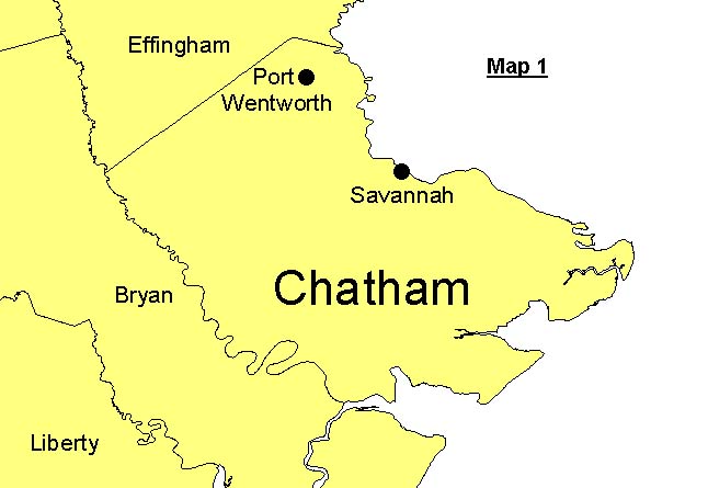 The City of Port Wentworth, incorporated in 1957, is a small community located in northern Chatham County, just outside of Savannah (Map 1). Originally a "company town" of the early 1900’s, Port Wentworth is a bedroom community with limited employment opportunities and very little commercial activity. The city thrived during the 1970’s, but with the construction of Interstate 95, activity from travelers was removed from Port Wentworth and the town has been declining ever since. The grocery stores, doctor’s offices, banks, and restaurants have all closed their doors. The Savannah Harbor of the Georgia Ports Authority is located just outside the city limits, as are a pulp and paper mill and other industrial sites. These uses have created an image of Port Wentworth as an industrial town, and this image is strengthened throughout the region as industry continues to thrive at the city’s borders. On the surface, Port Wentworth seemingly has little to offer to newcomers, while tremendous growth occurs in other municipalities of west Chatham County.
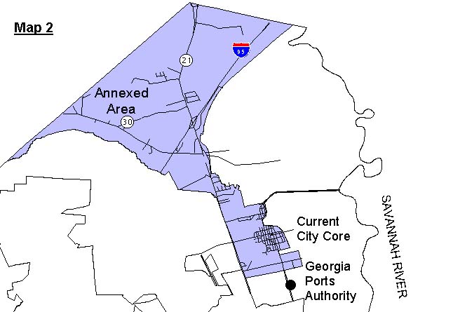 The majority of residents in Port Wentworth live within the core area of the city, which is bordered by the Savannah River to the east, the Georgia Ports Authority to the south, industrial development to the west, and St. Augustine Creek, a large tributary of the Savannah River, to the north (Map 2 ). Although the City annexed approximately 5,000 acres of land in 1989, located northwest of the core city near the intersection of Interstate 95 and State Highway 21, this area has experienced little development, mainly due to lack of infrastructure.
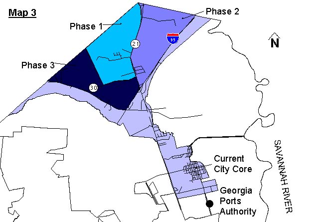 After the public meetings, comments were forwarded to the architectural firm of Lott + Barber Architects to prepare the master plan. Development of the master plan began in the summer of 1999, guided by TND principles, but still reflecting the uniqueness of Port Wentworth. Phase 1 of the new development area, which is approximately 2,100 acres, will include a prominent park in the center of town for festivals and other public activities, and a series of neighborhoods connected by a multi-purpose trail system. Each neighborhood, as well as the downtown, will have access to commercial activities, such as the corner grocery or drug store, within walking distance to most residents. The trail system will provide both recreation and alternative transportation opportunities to all residents. Housing options will be diverse, including a range of single-family homes, town homes, multi-family housing, and assisted-living homes. To guide this future development, all development regulations and zoning ordinances are being rewritten to promote pedestrian-oriented design, conservation of natural areas, mixed land uses, and many other elements identified as important by the community. The City estimates that Phase I will include 6,000 to 7,000 housing units and will have a build-out of approximately twenty years. Phases II and III will add another 3,000 acres to the development (Map 3).
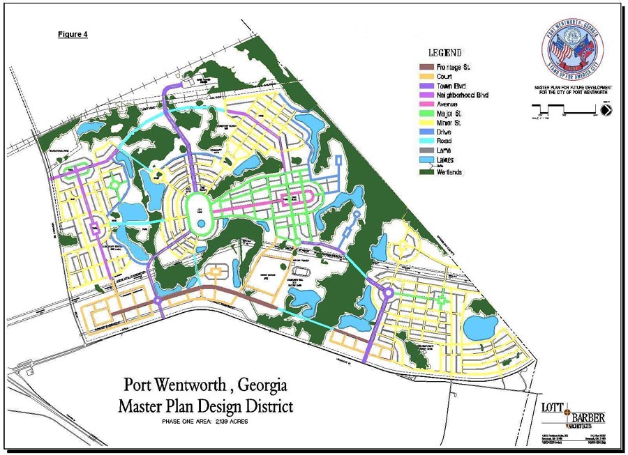 The master plan is illustrated in Figure 4. Wetlands are indicated in green and lakes are indicated in blue. The streets are various colors depending on the street classification. The master plan addresses all land use regulations through street classifications, rather than by conventional zoning. Street classifications determine uses, lot sizes, setbacks, and all other development regulations. This mechanism will allow more flexibility for market conditions to determine appropriate use, rather than forcing a use that is not needed or is undesirable. By tying regulations for the built environment to the street classifications, streetscapes can develop with appropriate scale and other characteristics that are consistent with the community envisioned by the citizens. All streets require sidewalks on both sides and shade trees in a ten-foot tree yard. General descriptions of the street classifications are as follows: