
Since 1988, the New Jersey Office of State Planning (OSP) has been developing a computer model intended to facilitate the preparation of state, county and -- ultimately -- municipal land-use plans. Our model allows its users to abandon the traditional map-based planning approach, which is labor-intensive and costly, in favor of a computerized process of projecting policy-driven municipal forecasts.
Our goal has been to provide regional planning agencies with a growth-management planning tool that uses state-of-the-art GIS (geographic information system) and statistical research, both of which are embedded in the program, to realistically simulate the spatial consequences of a large number of user-selected, policy-driven scenarios. The model also quantifies some of the capital and operational impacts associated with the resulting growth pattern to provide the user with additional criteria -- in addition to the success of growth distributive policies -- for evaluating alternative scenarios.
This program, called the OSP Growth Simulation Model, is not a black box that automatically produces the "'best" plan for a region. In fact, the model cannot by itself select plan alternatives, nor can it evaluate model results. Instead, its use allows planners automatically to avail themselves of the best available data and documented forecasting and analytical methods. The model also allows planning agencies to spend more of their time and money on evaluating the opportunities and constraints of alternative growth-management policies, than on collecting, interpreting and mapping data. In effect, the model allows users to do more planning, and it phrases "plan" alternatives in simple, unambiguous policy language readily understandable to non-professionals.
Our hope is that the review of alternative model runs will allow regional planning agencies to refine their growth polices, and through this iterative process, to identify a realistic growth policy strategy that best serves their region.
The model uses GIS information, more conventionally available data, such as information from the U.S. Census, as well as information catalogued by several state agencies, such as the New Jersey Department of Transportation (road miles), the New Jersey Department of Labor (employment from unemployment insurance) and the New Jersey Department of Environmental Protection (detailed information on sewer treatment and collection, parks, and natural and historic features).
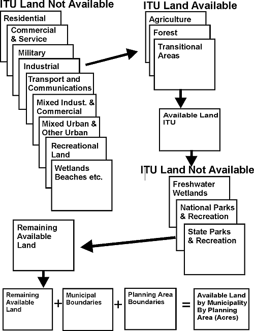
The major activity performed by the GIS portion of the growth simulation model is to determine the amount of land available for development in each of the 567 New Jersey municipalities. To perform this calculation, the OSP primarily used the Integrated Terrain Unit (ITU) GIS boundary files prepared by Environmental Systems Research Institute, Inc., under contract to the New Jersey Department of Environmental Protection (NJDEP). This state-wide inventory of various natural and man-made attributes was developed from 1986 aerial photographs that were interpreted and ground-verified. Figure 1 illustrates the various GIS boundary files that were merged to identify available, developable land in each municipality.
Figure 1. Obtaining Land Availability Information Using GIS
The model was written using the programming languages supplied with Microsoft Excel. It consists of three functional elements: data sheets, worksheets that calculate algorithms, and programming code. Each major activity of the model (e.g., assigning trend growth or estimating municipal operating expenses) is structured as a separate program, each with its own worksheets and programming code. This modular construction allows the model to be debugged or revised incrementally. The major function performed by the model is to allocate growth to available developable land, in each municipality, and then to calculate selected municipal impacts associated with each growth distribution.
This growth allocation process begins by converting the selected regional population forecast into a forecast of new houses that need to be constructed between the base year and the forecast, or horizon, year. Next, a preliminary, or "raw," assignment of total new houses in each county or region is made to each municipality within the county, based on a mathematical model derived from published empirical research studies of population growth (Isserman 1977; Smith 1987, 1988, 1990; Siegel 1953, 1972). This mathematical assignment method is highly reliant on the growth rate of each municipality during the previous (historic) decade.
The preliminary housing assignment is then tested against the known supply of available, developable land in each municipality. If sufficient land exists, then the preliminary assignment is accepted. If there is not sufficient land, then the available land is developed and any excess growth reassigned to other municipalities in the county. Finally, the model converts municipality-specific horizon-year housing into a forecast of population.
Total municipal employment is then assigned, using the statistical relationship between housing growth, local road density and total jobs. This assignment method, too, is based on published research (Putman 1983, Boarnet 1994), and was verified using New Jersey-specific data. Job growth is determined by subtracting base-year employment from the forecast.
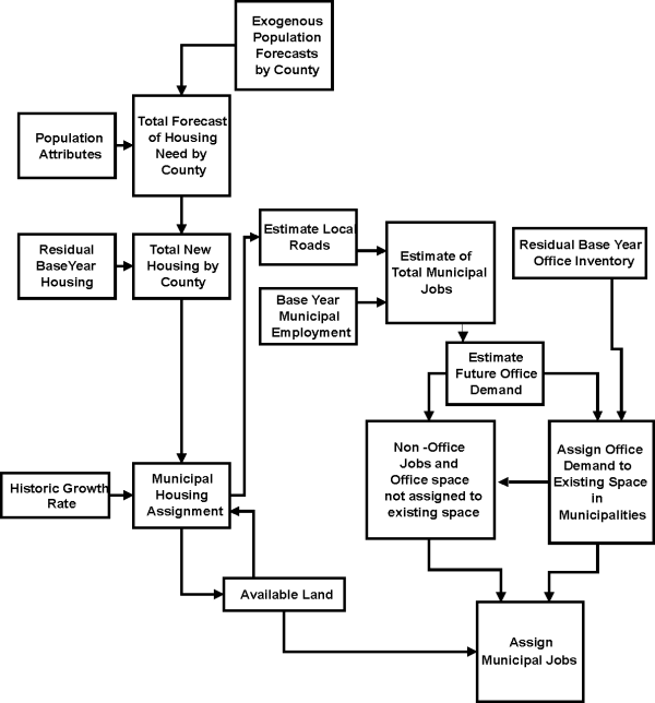
Some jobs are then assigned to existing office space that is forecast to remain in the forecast year. To accomplish this task, the amount of county job growth that likely would be accommodated in office-like buildings (that is to say office growth from the base year to the horizon year) is estimated and then assigned to the (also estimated) residual inventory of available existing office space. Office employment that cannot be accommodated into surviving existing office buildings and all non-office employment then is assigned to municipalities and converted into a land consumption footprint. As with housing, this forecast for job-related growth is then compared to the municipal specific supply of available, developable land. The preliminary employment assignment is either accepted, if sufficient land exists, or reassigned, in whole or in part, if land is scarce. Figure 2 illustrates this assignment process.
Figure 2. A Schematic of the Assignment Methodology Making Employment Endogenous
In the case of New Jersey, the OSP model converts 21 county forecasts into 567 municipal forecasts of population and employment. The model also forecasts the following municipality-specific variables: mean household income; the number of households in each of eight income categories; average household size; and the distribution of households by six household size categories -- all important variables in making travel demand forecasts and air quality forecasts. These forecasts are then reviewed by the county or regional planning agencies, and calibrated to more closely conform to growth patterns, developer interest or zoning changes, especially downzoning, that have emerged since the model's base year of 1990.
The resulting calibrated forecast is termed a "trend," or market-driven, forecast. It is not considered to be deterministic (absolutely correct), but is thought to represent a realistic forecast of relative municipal growth within the county or region. It demonstrates what and where growth is likely to occur if existing and known development trends continue -- and if the user-specified estimate of regional growth is reasonably accurate. The purpose of the trend forecast is to specify a likely "do nothing" municipal forecast, which the user feels is reasonable, and against which alternative plan results can be compared.
Once the trend forecasting phase is completed, the user can begin to specify various "plan" growth policies that act to modify the trend forecast. The plan simulation now incorporated into the model uses the policy handles and planning language found in the New Jersey State Development and Redevelopment Plan, more commonly known here as the "State Plan." In essence, the model allows users to simulate sprawl, or to channel growth into existing or new communities. Growth can be re-assigned to emphasize redevelopment, infill or the encouragement of development into more rural areas. The model also allows the user to experiment with a large number of development-related program characteristics, such as residential and employment density, job-to-household ratios, and growth capacity for new development.
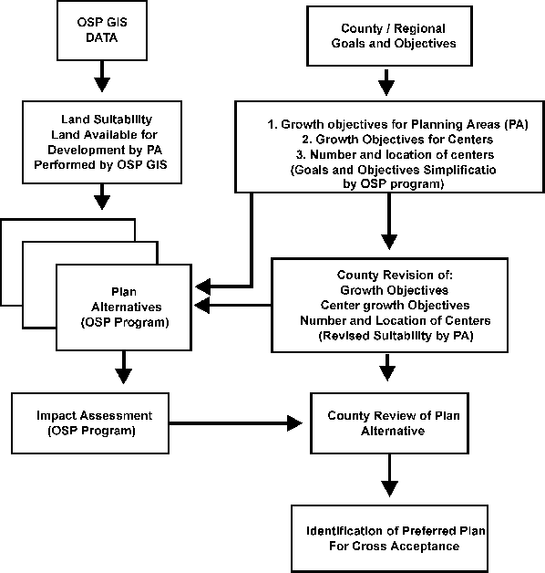
Finally, the model has several programs that evaluate for any given scenario, the following impacts: amount of land expected to be consumed by the horizon-year; school capital costs; local road costs; public sewer capital costs (including the costs of meeting the Clean Water Act); and municipal expenditures in the forecast year. By comparing the results of trend to alternative plan policy scenarios -- and by comparing results between plan scenarios -- it is hoped that a preferred regional growth plan can be refined. This iterative process is shown in the Figure 3.
Figure 3. Planning as an Iterative Process: Using the OSP Growth Simulation Model
The first public review of model results in 1994 was both disastrous and informative. OSP initially had developed a primitive version of the model with the intent of using it to test in-house policies and to develop more realistic baseline programmatic forecasts, such as the number of new houses needed in the forecast year. In this early form, the model's ability to produce accurate municipal forecasts was less important than its ability to reasonably simulate the effects of policy. Therefore, many of the forecasting methods in the model were based on "rule of thumb" or "common sense" algorithms.
In 1993, the New Jersey Department of Transportation (NJDOT) provided funding from ISTEA, the federal Intermodal Surface Transportation Efficiency Act, so that the model's assignment and allocation procedures could incorporate more reliable methods. The OSP performed statistical research to document methods of forecasting household size and income, by income group, at the municipal scale (Reilly, forthcoming). The model base year was advanced from 1980 to 1990, and statistical relationships based on cross-section 1980 data (especially STF3) were revised to reflect the 1990 census data. Finally, a single plan alternative was programmed, which assigned all growth to fill the more densely developed municipalities before it assigned any growth to more suburban or rural areas. This alternative reflects one of the formal policies of the New Jersey State Plan, and one which has been reviewed and approved by all of the county planning agencies through a process known as "cross-acceptance," which is designed to ensure the mutual compatibility of statewide and local planning. The NJDOT hoped the model's plan forecast could be used as the land-use base for the travel demand and air quality studies required of it under ISTEA.
The NJDOT released the model's plan municipal forecasts for review in 1994. In the more developed portions of the state, the forecasts were accepted as reasonable accurate. However, in less developed, and especially, in the more rapidly growing parts of the state, the forecasts were flatly rejected.
We learned a great deal from this painful experience. First, we learned that grand-sounding regional growth policies may not look so reasonable when the municipality-by-municipality growth implications are made explicit. It became clear that a single Plan growth-management strategy probably was not responsive to the differing conditions throughout the state. This knowledge resulted in the revisions, now found in the model, that allow county planners to construct their own plan scenarios. Second, we learned that county planners needed to calibrate the model, both to ensure it could accurately produce a trend forecast that seemed reasonable and to ensure that these professionals were comfortable with the base data and existing condition information embedded in the model.
Toward the end of 1995, we began the first round of beta testing on the growth simulation model with the invaluable assistance of Alice Brees, PP, AICP, principal planner with the Sussex County Department of Planning, Development and Human Services, and Laurette Kratina, senior planner for the Somerset County Planning Department. Working with these planning practitioners produced many minor changes to the model, and some major ones.
Perhaps the most fundamental of these changes was that the OSP was forced to revise how the model would be used in practice. Originally, we had thought that the model would be run by OSP staff, with user input and model results conveyed by fax or Internet. Working with only two counties demonstrated that this approach would require a full-time operator of the model at the OSP.
As a result, the model was retooled to be more "user friendly," and our approach changed to one in which OSP staff installs the model on the user's PC, so he or she can run it. This approach has the added advantage of allowing the user more freedom to "play" with the model.
Beta 1 testing also demonstrated the need for local planning professionals to be assured that base data in the model is accurate. We originally approached this problem by supplying base data, in printed form, for county review before using the model. This system proved cumbersome, so the program code was revised to allow users to examine the model's base data directly. Similarly, model calibration has been changed from a somewhat complex activity performed only by the OSP, to an easy-to-use, stand-alone subroutine included with the program. By 1996, both test counties had produced trend forecasts they felt were reasonable. Model calibration can now be accomplished in a few hours, or less, by the user.
The Beta 1 testing process also resulted in substantial changes to the revised plan subroutine. More development program variables were added at the request of the testers. A major revision was designed to allow model users to easily revise both the number and the location of proposed new development (called "Centers" in the language of New Jersey's State Plan). Another revision causes plan alternatives to produce detailed reports of land consumption in each municipality. With these reports, planners can more accurately gauge the success of plan policies intended to preserve farmland, to cite just one example.
Finally, beta testing has resulted in changes to the impact subroutines in the model. The sewer impact model has been revised to allow the model user to test alternative 208 service plans. The housing estimation subroutine has been revised to report some of its more detailed demographic results. This information has proven useful in the development of county-level housing and elderly care plans.
Not all of the beta testing has resulted in solutions. For example, one of the impact subroutines calculates forecast-year municipal current expenditures. But beta testers said they found the forecast to be difficult to use in practice. Although the statistical model is sensitive to density changes, as well as changes in the number of jobs and houses, beta testers contend that the current output of total forecasted municipal expenditures is too easily dismissed. They found, for example, that the model indicates that more development results in more municipal spending, to a great degree. The testers suggested that the ability to forecast changes in the effective tax rate might be a more useful index.
As of early 1997, the OSP is in the process of coping (what does this mean?) the Beta 2 version of the model and distributing it to various regional planning organizations in New Jersey. Our hope is to discover additional "bugs" and opportunities. We hope to conclude this Beta 2 testing sometime in May 1997. Our goal is to have a release version of the model available for use by all New Jersey planning agencies by the summer of 1997. Our intention is to have these agencies use the model as part of the upcoming cross-acceptance review process, mandated to occur every three years by the New Jersey State Planning Act. Because the model phrases user- developed plans in the language of the State Plan, we are hopeful that the modeling exercise will generate a lively re-examination of the Plan.
Although we feel that the model has proven to be a useful regional planning tool, there remains the serious problem related to how believable the model's results really are. There are at least two aspects which contribute to this issue.
First, the model's forecasts ultimately rely on statistical analysis, calculus and other mathematical mysteries. Statistics is popularly understood to the science of lying, a charge that is not altogether groundless. Another type of complication is that it has proven difficult for planning practitioners, who had an introduction to these subjects in college and/or graduate school, to fully understand the detailed technical reports produced by the OSP to document the methods used in the model. Therefore, it becomes extremely difficult for planning practitioners to describe these methods in vernacular at meetings. (In fairness, it is also difficult for the OSP to explain these methods to non-professionals, and to many professionals, without resorting to technical terms.)
The second aspect is the fact that the mathematical tools used in the type of analysis do not produce absolute answers. A strong public belief is that computers should produce results that are 100 percent accurate -- not forecasts that are generally reasonable except for the fact that their town is an outlier, due to some extraordinary local condition. The public perception (and the bureaucratic demands of many infrastructure provides) is that forecasts must be either totally right, or if any part of the forecast appears to be wrong, then the whole forecast must be wrong.
Ultimately, the success of the model relies on the public and professional community's acceptance of what models like the OSP Growth Simulation Model are realistically capable of doing. We contend that an appropriate expectation for models like ours is that they spatially forecast alternative growth scenarios, alternative future demographic conditions and alternative land-use polices in a realistic fashion.
Although the model uses a horizon year, each model run should be viewed in a timeless perspective; the growth forecast ultimately should be viewed as a plan capacity that might be achieved sooner or latter. The model's spatial forecasts can be useful to identify a preferred future land use, but the successful achievement of that development pattern hinges on subsequent decision-making and implementation activity, including the timely provision of form-determining infrastructure like roads and sewer systems, to guide growth towards the land-use plans envisioned with the help of the model.
Boarnet, Marlon G. (1994). The Monocentric Model and Employment Location, in Journal of Urban Economics 36, 79-97.
Isserman, A. (1977). The Accuracy of Population Projections for Subcounty Areas, in Journal of the American Institute of Planners 43 (3), 247-259.
New Jersey Department of Environmental Protection (1995). GIS Data Series: Integrated Terrain Unit Mapping Analysis, ESRI, Inc., Redlands, CA.
Putman, Stephen H. (1983) Integrated Urban Models. Pion Limited, London.
Reilly, James (forthcoming). A Method to Assign Population and A Progress Report on the Use of a Spatial Simulation Model. Environment and Planning b: Planning and Design.
Siegel, J. (1953). Forecasting the Population of Small Areas, in Land Economics 29 (1), 72-88.
Siegel, J. (1972). Development and Accuracy of Projections of Population and Households in the United States, in Demography 9 (1), 51-68.
Smith, S. (1987). Tests of Forecast Accuracy and Bias for County Population Projections, in Journal of the American Statistical Association 82 (400), 991-1003.
Smith, S., and Sincich, T. (1988). Stability Over Time in the Distribution of Population Forecast Errors, in Demography 25 (3), 461-474.
--------------------------------- (1990). The Relationship Between the Length of the Base Period and Population Forecast Errors, in Journal of the American Statistical Association 85 (410), 367-375.
James Reilly, Sr. Research Planner
New Jersey Office of State Planning