
Phoenix is no stranger to rapid growth. In the last 30 years Phoenix doubled its population to over a million people, an effective annual growth rate of 2.5%. Phoenix now encompasses over 500 square miles of which nearly over one half is undeveloped . Currently Phoenix is experiencing one of the fastest job and housing growth rates in the nation. Much of this growth has been fueled by mild winters, high environmental quality, low cost of living, and available inexpensive land. Though Phoenix historically has had pro-growth attitude it has also taken a very business like approach to city management. Thus the financial impacts of growth and effects on the characteristics attracting growth, such as environment, have been a focus of community planning.
During the last few years, Phoenix has begun to take a strategic view of growth. Phoenix and the surrounding valley communities have reached an important point in the form and function of the urban system. Historical patterns of job growth, residential growth, and travel are about to undergo significant changes. Phoenix has begun to analyze these regional changes, how they may affect Phoenix, and what strategies are needed to maintain a financially healthy community while maintaining its quality of life.
Based on this analysis, Phoenix has begun to modify its planning efforts to reflect this strategic view of growth. Current planning efforts are now focused on managing long term employment and residential growth, encouraging short term infill of inner city areas, protecting the Phoenix' unique desert resources, and linking economic development efforts more closely with community needs and growth goals.
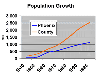
Historically, growth in Phoenix has shifted from initially within the borders and annexed areas of the city to part of rapidly growing region. Though Phoenix' share of the regions population has slowly declined, it is not land locked by surrounding communities. Table 1 and Figure 1 illustrate population change for Phoenix and Maricopa County between 1940 and 1990.
Table 1: Phoenix and Maricopa County Population
Year | Population | Phoenix Annual Growth Rate | Percent of County Population | Percent of County Growth | Maricopa County Population | Maricopa Annual Growth Rate |
| 1940 | 65,414 | 186,193 | ||||
| 1950 | 106,818 | 5.0% | 32% | 28% | 331,770 | 5.9% |
| 1960 | 439,170 | 15.2% | 66% | 100% | 663,510 | 7.2% |
| 1970 | 584,303 | 2.9% | 60% | 47% | 969,425 | 3.9% |
| 1980 | 789,704 | 3.1% | 52% | 38% | 1,509,262 | 4.5% |
| 1990 | 983,403 | 2.2% | 46% | 32% | 2,122,101 | 3.5% |
| 1995 | 1,149,417 | 3.2% | 45% | 39% | 2,551,765 | 3.8% |
Source:Phoenix, A Community Profile 1990, City of Phoenix Planning Department and 1995 Census
During the 90s and 80s as Phoenix continued to experience a healthy growth rate, adjacent suburban cities experienced rapid growth similar to what the city had in the previous two decades. The rate of growth in the suburban areas exceeded that within the city and Phoenix share of regional growth declined.
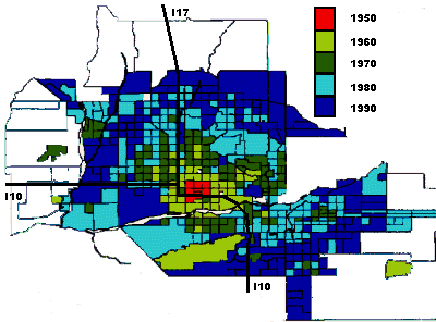
During this time frame growth was relatively unimpeded by natural barriers or lack of infrastructure. Growth occurred randomly at the fringes of the existing urban areas. Flat deserts and farm land posed little restrictions on development and their were no major freeway or arterial corridors to focus growth. Map 1 shows the location of valley growth up to 1990.
Map 1: Phoenix Growth By Year and Location
Throughout the period Phoenix financed its growth through bonding and grants. Federal grants, such as capital grants to finance waste water facilities, were used. A series of bond programs beginning in 1957 through 1988 provided major funding for new capital facilities and infrastructure necessary to support the city's growth. Table 2 denotes the amount of funds authorized by the voters in each of the city's bond programs.
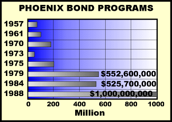 Table 2: Phoenix Bond Programs
| Year | Amount of Authorization |
| 1957 | 70,000,000 |
| 1961 | 103,000,000 |
| 1970 | 177,400,000 |
| 1973 | 56,500,000 |
| 1975 | 207,300,000 |
| 1979-83 | 552,600,000 |
| 1984 | 525,700,000 |
| 1988 | 1,000,000,000 |
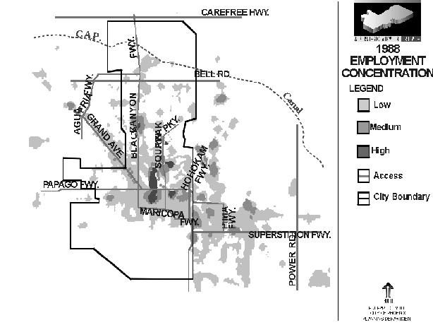
Concurrent with the expansion in the housing areas, employment locations were also broadened. Map 2 denotes the locations of employment concentrations in Phoenix and nearby communities in 1964. Major employment was located in most instances in central Phoenix with some minor employment in the nearby communities of Glendale, Scottsdale, Tempe and Mesa.
Map 2: Locations of Phoenix Employment Growth
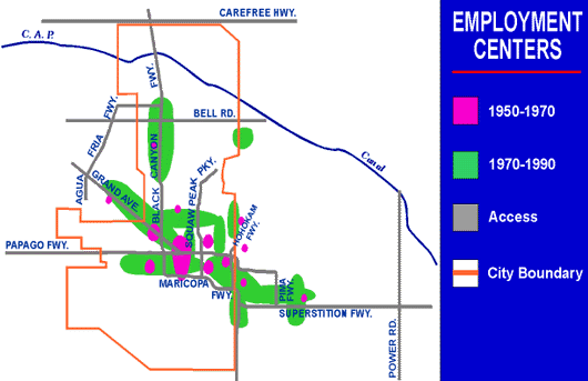
In the 1970's employment locations began to expand along transportation corridors extending in multiple directions from central Phoenix. Map 2 also denotes the location of employment growth by the end of the 1980's. Employment had expanded to both the east and west valleys as well as north, northeast and northwest of the center city. Employment was located in corridors valley wide, no longer just in central Phoenix. Map 3 illustrates employment concentration by jobs per square mile. Yet, even though employment areas were now located valley wide, up until the 90s Phoenix valley employment remained one unified labor market. This is because the commute time from all employment areas to all residential areas was within acceptable time frame, under 45 minutes.
Map 3: Employment Concentrations
 [Missing]
Though the economic engine that has driven growth over the last 30 years is still running at full steam, several new trends will alter historical patterns of growth in Phoenix and the valley. These are:
Map 4: Current Locations of Residential Growth
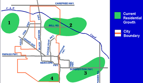
Though a review of aerial photographs of the metropolitan area will show that vacant land exists in a number of areas adjacent to the built community, the inventory of land which is serviced by infrastructure is beginning to decline. Map 4 shows the locations of current new residential growth within the Valley. Table 3 provides an estimate of build-out time for different parts of the valley. Current inventories show a relatively low supply of lots in all parts of the valley. Two parts of the valley show a significant future potential supply of lots, the North East (Phoenix and Scottsdale) and the South East (Chandler and Gilbert). However, the key to development in these areas is infrastructure.
Table 3: Build-out Time for Current Growth Areas (In Years)
| Area | Current Lot Supply | Future Lot Supply | Total |
| West Section(Phoenix and Suburbs) | 1.6 | 0.33 | 1.93 |
| Northwest (Glendale and Peoria) | 1.8 | 1.6 | 3.4 |
| Northeast (Phoenix and Scottsdale) | 2.0 | 8.6 | 10.6 |
| East Central (Tempe/Mesa) | 2.5 | 2.1 | 4.6 |
| South East(Chandler/Gilbert) | 2.4 | 6.0 | 8.4 |
| South (Phoenix) | 1.0 | 0.1 | 1.1 |
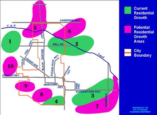
There are several areas that have the potential for new residential growth. These areas generally lie at the edge of current current residential growth areas, as shown in Map 5. However, residential growth in these areas is not certain. These areas face a new set of challenges that have not historically been issues.
Map 5: Potential Residential Growth Areas
During the last 10 years, the environment for financing infrastructure in the Phoenix valley has undergone some radical changes. In addition to decline in federal dollars, all the communities in the valley are now experiencing constraints on traditional means of infrastructure financing. Gilbert has recently called for a moratorium on growth in an effort to get a handle on infrastructure costs. Phoenix has not approved a new bond package since 1988. Currently it is estimated that additional debt capacity beyond that approved in 1988 will not be available until 2002. This combined with the increasing need for capital replacement funds will limit Phoenix ability to finance growth related infrastructure as it has in the past.
Anticipating this, in 1987 Phoenix became one of the first cities in the country to implement impact fees for infrastructure. This financing technique places more of the burden for infrastructure on the development community, and requires more planning and private/public sector partnerships to implement effectively. Since 1988 other valley cities have begun to explore impact fees as a source of funding for growth related infrastructure.
During the last ten years the community's attitude towards growth has changed as well. Though the community attitude towards growth is still generally supportive, most valley residents are now concerned about the effect transportation is having on air quality and the development of sonoran desert areas.
These trends are now beginning to channel residential growth into distinct growth areas. Unlike the random pattern of residential growth in the past, future growth will in areas where infrastructure can be economically provided, desert areas can be preserved, and housing can be located closer to employment.
Though employment in Phoenix and the valley continues to grow at healthy rates, future employment centers in the near future will not grow in land area as they have in the past. The land area of current basic employment centers are unlikely to expand significantly in the near term given that substantial zoned vacant land remains available within the corridors for future employment opportunities. Table 4 provides an inventory of vacant land within key basic employment centers. Most of these have sufficient inventory to last a number of years.
Table 4: Vacant Acreage Available for Additional Basic Employment
| Employment Area | Acres Available |
| I-10 West Phoenix | 4,300 |
| I-17 North Phoenix | 2,700 |
| Tempe/Gilbert | 2,700 |
| Scottsdale Airpark | 2,500 |
| Mesa/Superstition | 1,600 |
| Desert Ridge Phoenix | 900 |
| S I-10 Chandler | 400 |
| Phoenix Sky Harbor | 240 |
Source: Review of aerial photographs of basic employment designated/zoned land.
The same is true for the valleys office employment centers. Table 5 provides a summary of current and approved office square footage for four office cores in Phoenix. All of these have sufficient capacity of additional land with approved zoning to double in size.
Table 5: Central Phoenix Office Capabilities
| Current | Additional | |
| Submarket | Square Feet | Capacity (SF) > |
| Camelback Core | 3.8M | 6M |
| Central Corridor | 9.0M | 16-20M |
| Downtown | 5.0M | 6-8M |
| 44th Street | 2.5M | 10M |
Source: City of Phoenix estimates
Future employment growth will also be more directly linked to residential growth as well. As the valley has grown, the time it takes to travel from one part of the valley to another has increased. This is due to both an increase in the physical distance and increased congestion of freeways and arterials at peak hour. This increased travel time is beginning to fragment what has historically been a unified labor market. Several trends provide indications of this change.
First, even thought the valley has gotten larger, the average travel time to work in the Phoenix area, 21.6 minutes, is only slightly higher than in 1980 and remains under the United States national average in 1990 of 22.4 minutes. Also, an analysis of 1990 census data of work and residence locations for specific employment centers in Phoenix shows that workers have begun to locate their homes in close proximity to where they work. Maps 5 and 6 shows an analysis of residence in relationship to work location for two such centers in Phoenix. Both of these maps show a clustering of residence around these employment centers.
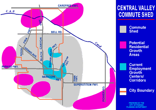
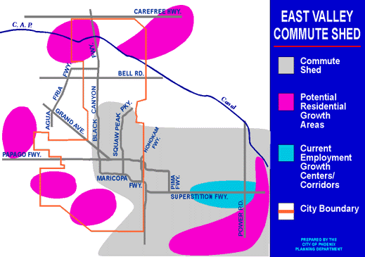
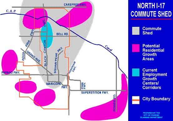
Second, an analysis of commute times around the valley employment centers begins to show that each employment center begins to include residential area that are exclusively within their 30 minute commute shed. Maps 6, 7 and 8 show the commute sheds for three valley employment centers. Most of the residential areas are located at the fringe of the urban areas, and represent the residential growth areas of the valley.
Map 6: Central Area Commute Shed
Map 7: East Valley Commute Shed
Map 8: North Area Commute Shed
Lastly, an analysis of the labor force in each of the current commute sheds are beginning to denote some distinctions in workers as categorized by profession and industry. The work force in the East Valley commute shed has a larger percent (18%) of its labor force identified as professional specialist; a larger percentage employed in manufacturing (17%), and a larger percent with Bachelor and Graduate Professional degrees (22%) than the other commute sheds. Conversely, the labor force in the West I-10 commute shed has the highest percent of work force categorized as machine operators (8%) and the lowest percent with Bachelor and Graduate Professional degrees (17%). Along with the Grand Avenue commute shed work force, they share the lowest percent of the work force designating Professional Specialist as their profession (15%).
As new residential construction occurs further on the periphery, commute sheds will likely intensify around major employment locations. This will result in the metropolitan labor market becoming fractured into specific labor markets within a comfortable travel time to each employment area.
As the commute shed phenomena solidifies, there will be implications for each distinct employment market. The markets which will have room to add new residences within their individual commute sheds will be able to provide the additional housing opportunities to attract an increase in employment. Markets limited by the ability to expand their housing base may not have the opportunity to grow since they may lack the ability to attract additional workers to their respective employment zones.
There is also the potential for the development of new employment centers within the areas of future residential growth. Existing and new major freeways located in the West, North and East Valley have the potential to serve new employment centers. Map 9 shows some of the potential new employment centers. These areas will be closely linked to residential growth and freeway locations.
Map 9: Potential Employment Centers
The last area of change impacts public revenues. The basis of Phoenix' ability to financially provide services to its citizens rest on a three leg stool with each leg linked to the other. The first leg is that basic industry creates community wealth. The second is the employees to whom much of this wealth is transferred. The last is retail sales from which Phoenix obtains sales tax revenues.
In the past, the most important leg of this stool was the site where retail sales occurred. As long as it the retail sales occurred in phoenix, it did not matter where the basic industry was located or where people lived. And in fact up until the late 80s this is exactly what happened. Even though a substantial amount of residential growth and employment growth was located outside of Phoenix, Phoenix was still receiving a larger share of per capita sales. This is primarily because most of the opportunities for retail sales were located in Phoenix and a reasonable travel time from suburban communities. It did not matter where people worked or lived, it was still attractive and easy to make retail purchases in Phoenix.
However, this trend has begun to change. Phoenix's share of per capita sales, even taking into account differences in household incomes, has been steadily declining. As residential areas move farther away from central Phoenix, central shopping opportunities become less attractive and suburban markets reach sufficient critical mass to support new, suburban retail centers.
This trend will only be accelerated by diversification of employment commute sheds. The spatial link between employment centers, residential areas, and commercial areas will become more critical to a community's future financial health.
Based on these anticipated changes in growth trends, it has become clear to Phoenix that past strategies used to facilitate employment and residential growth will no longer be adequate. In this new environment of growth, the communities that can best respond to this changes will fare the best financially and in the ability to maintain a high quality of life.
In anticipation of the changes, Phoenix has begun to develop new economic development and planning strategies to position Phoenix to benefit from these changes. These strategies center around four key concepts.
Based on these concepts, Phoenix has initiated a variety of new programs and modified old business practices to better position the City to take advantage of future growth opportunities. The goal is to maintain a financially healthy community which maintains a high quality life. These breadth of the programs may be comprehensive but the actions are focused on effecting key strategic results.
Phoenix development strategies historically were reactive to market demand. As employment opportunities arose, the City responded with technical expertise to aid in the development of employment facilities for the community. During the recession which occurred in the late 1980's, a significant amount of employment space became available within the community. This made it relatively easy for the City to assist in employment expansion. The abundance of available space enabled the community to offer employment space on a very competitive basis to both national and local markets. As this space has been filled, this advantage is no longer as evident.
New strategies are being developed to reflect Phoenix's need to compete in local and national markets for employment opportunities. In basic employment, the City has identified both target industries they desire for employment expansion as well as specific employment centers within the city for the location of employment.
The target industries approach has identified 18 industries which the city hopes to expand or attract as part of the city employment base. These 18 industries fall within four major categories; Manufacturing (medium and high technology), Corporate headquarters, Corporate auxiliary support or regional operations, financial, and research and development. For each industry, an industry profile is developed to determine what is required for its success. The type of labor force, land, access required, etc. are analyzed.
Correspondingly, data bases are created on the eight city employment centers denoting labor type and supply, infrastructure service, available land as well as weaknesses that need to be addressed in order to enhance each center's attractiveness. The eight employment centers the City has identified are generally located within the Central Valley, North East Valley, North I-17 or West I-10 commutes sheds.
The profile developed for each employment center provides a description of key economic elements that are of interest to business. These elements include an overview of the employment center, growth characteristics, labor market, infrastructure, statistics and referenced studies. The labor profile for each center includes information on the labor force for 10, 20 and 30 minute commute sheds.
With this information, the City is quick to respond to employment opportunities interested in locating or expanding in the metropolitan area. With the knowledge of the distinct labor market and infrastructure in each center, the City may market appropriate areas to the respective business that match the needs of the business.
The city is also in a position to coordinate a myriad of incentive programs available through federal, state and other governmental jurisdictions that assist in the development of employment facilities and provide employee training. With this technical expertise, the city can approach potential employers with a site inventory meeting their requirements and some potential incentives to assist in realizing business development and employment growth.
The key to future residential development with in Phoenix's growth corridors will be the provision of infrastructure. Phoenix has a head start on other valley cities because of it well established infrastructure fee program. This program has already generated funds being used for growth related roads and parks. But this program alone will not be enough. Phoenix is also beginning to look strategically at managing growth in a fashion that maximizes the efficiency of infrastructure development.
To this end, Phoenix has begun to coordinate land use decision with infrastructure management. Historically, infrastructure planning was primarily responding to growth trends and planned development. Now Phoenix is attempting to guide growth in areas where the cost effectiveness of infrastructure can be maximized.
As noted earlier in this report, residential growth will likely continue to expand further out from current employment centers. The likely new residential areas will provide an expanding residential base for the West I-10, North I-17 and East Valley commute sheds. However, the Central Valley does not have any significant current new construction residential activity within its future commute shed.
It is likely that the Central Valley employment area will be outside of most new residential housing areas by the year 2020. Only south and southwest Phoenix have significant vacant land to provide for new residential development within the Central Valley commute shed. Currently south and southwest Phoenix are not active housing areas for new residential construction. For south and southwest Phoenix to become active in the new construction residential home building market will require some effort. The area home building market is currently not involved in residential development in these areas nor are they actively expressing any interest in future residential development. This is primarily due to a poor access, lack of infrastructure, a financially struggling school district, and a general poor public perception of the area on the part of the community at large.
The City has actively begun to bring southwest Phoenix land owners, residents and school officials to together with City wide developers to identify the barriers to single family development. Based on this dialogue it is hoped that a partnership and plan can be formed that will over come access issues, provide the school district with new financing options for new facilities, and improve the market appeal of the area.
Preservation of Phoenix north sonoran desert resources has become a high priority to the community. Unfortunately, the resources exist in areas of high development pressure. Recognizing this dilemma in 1987, Phoenix adopted a plan for the northern part of the City that called for a change in quality and design of traditional development to preserve both desirable sonoran desert hills and flat lands, but also to preserve the western rural character of the area.
In 1995 Phoenix adopted a Desert Preserve Concept plan. This plan calls for the acquisition and preservation of 12,000 to 16,000 acres of sonoran desert mountains, flat lands, and washes in North Phoenix. Currently Phoenix is developing an acquisition strategy in cooperation with the Arizona State Land Department to implement this plan. In 1996, Phoenix adopted a set of new general plan policies that further preservation of desert areas. These policies shift densities out of sensitive sonoran desert areas into areas where more concentrated development is more appropriate. This policies also linked individual project densities to site characteristics which indicate the carry capacity of the land. Wash locations, vegetation quality and flooding characteristics are used to determine appropriate densities and clustering. These policies also recognize the importance of key major wash corridors in maintain a stable regional environment. Development polices along these corridors call for very low density low impact development.
Another option to provide new residential housing within the Central Valley is through infill development. With the lack of substantial new residential subdivisions within a comfortable travel time to the Central Valley, infill housing will be increasingly important to address the housing need for an expanding labor force.
However, over the last 10 years, very little infill has occurred with only a limited number of developers initiating infill projects. Creating a significant net new housing production within the Central Valley travel shed will be difficult. In an effort to understand the barriers to infill development, the Planning Department in 1995 conduct an analysis of infill development and identified the opportunities and barriers to infill housing. This study documents financial difficulties in developing small scattered sites surrounded by existing neighborhoods, the poor perception of some neighborhoods by the community, financial institutions and many potential buyers.
In an effort to overcome these barriers, the City has focused efforts on strategic locations to try and effectuate changes in attitudes and economics. In 1996, the City successfully attracted two multifamily projects within the downtown core area. The City has also initiated a single family incentive program that provides infill residential developers with fee waivers and accelerated project review for infill development in targeted areas. In 1995 and 1996 the City focused a program of enhanced enforcement and financial assistance along with rezoning and free site planning work as part of the State auctioning of 200 homes and 100 acres of land along Paradise Freeway. The Paradise was a proposed central city freeway that was scrapped in 1995. This program resulted in significant rehabilitation with in neighborhoods that had been depressed by years of living I the shadow of a future freeway. 100% of the homes auctioned for home ownership, and several new single family infill projects were started.
Recognizing the role that retail and sales tax plays in Phoenix ability to generate public revenue from economic growth, the City has focused on the role retail uses serve in community development through out the City. Areas that have been identified as being under served by retail development have received close scrutiny. In these areas efforts have been initiated to facilitate new retail development, either through rezoning or development incentives. The City is also exploring the possibilities of sales tax sharing with adjacent communities. This would help to eliminate the aggressive competition that exists between cities as they try to attract retail development to their borders.
In its long range planning efforts, Phoenix has begun to quantify and allocate sufficient commercial sites to serve future growth. In some areas, the residential market is so lucrative that land owners would rather sell now for residential use than wait for a future commercial buyer. Phoenix has attempted to insure that designated commercial sites remain viable for future commercial use, warding off sites become to small or being shifted to less desirable locations.
Over the past 8 years, two regional efforts to secure a dedicated funding source to expand the valley's transit system have failed. Both of those efforts were sales tax votes. The concern about traffic congestion and air quality has grown significantly during that time period. Addressing this air quality issue is recognized as being critical to maintain a healthy growth rate in the valley. Transit is still considered a key component of the solution.
The City of Phoenix has launched two efforts to try and generate viable transit solutions, First, in 1996 in an effort to gauge the mood of City residents towards transit and to begin to identify solutions for which there may be consensus, the City held a series of focus groups and public transit forum in each Council District. Council members and City managers attended these meetings. At these meetings the desire for more routes and more frequency was strong.
Based on these meetings a Phoenix citizens committee for transit was formed. The committee is large to encourage a broad range of participation. Part of this committee's effort is to prepare a campaign for a sales tax vote for transit. Currently the committee is considering including a rail component in their proposal.
Phoenix has jointly with Tempe initiated a transit corridor feasibility study. One goal of the study is to identify a mode and alignment. This is one of the first steps that will be required if Phoenix wants to apply for federal transit funds. To this end, Phoenix has been working in the coalition 'New Starts' cities which are trying to get rail going in their communities. The idea of new starts is to change cities from competing with each other for capital dollars to start projects, and instead, join in lobbying together to get a bigger pool of dollars.
Phoenix's development of its new strategic view of growth was not a revolutionary event. Many of the programs described here would likely have occurred in some form regardless. The difference is that they all have been adjusted to incorporate the "view's" key strategic concepts. The "view" has become a common ground between traditionally separate views and processes. In has brought forward a common basis to manage land use, infrastructure, economic development, public revenues, desert preservation, and environmental quality. The "view" has given people a better understanding of how the community functions, how each element and area plays a role in the whole community. It has given the community and its leaders an understanding that growth need not be evil force if wisely managed. It has given them an understanding of how it needs to be managed, the benefits of this management and the costs of failure to manage.
In itself the view is not a vision of the future. Rather it is a "view" of the role growth can play in helping the community can achieve its vision of the future
Ray Quay,AICP
Assistant Director of Planning
City of Phoenix
rquay@ci.phoenix.az.us
Jim Mathien
Planner III - North Planning Team Leader
City of Phoenix
jmathien@ci.phoenix.az.us
David Richert
Director of Planning
City of Phoenix