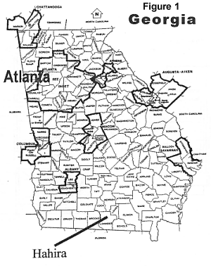
 Hahira (pronounced HAY-HI-RUH) is a town of 1,300 some 220 miles south of Atlanta and six miles north of Valdosta (see figure 1). It was founded in 1891 as a railroad town, providing a market place for the region's tobacco farms. The annual tobacco market, with its large warehouses and auctions, gave Hahira an identity lacking for many small towns in the area. Indeed, Lowndes County's two largest banks were founded in Hahira.
A building moratorium, imposed because the town had an inadequate sewerage system limited growth during the 1980s while the rural area surrounding it more than doubled in population. With the installation of a new sewer treatment plant and new sewer mains, the development wraps came off and with that came requests by developers to annex their land to the city to accommodate several hundred housing units.
Hahira (pronounced HAY-HI-RUH) is a town of 1,300 some 220 miles south of Atlanta and six miles north of Valdosta (see figure 1). It was founded in 1891 as a railroad town, providing a market place for the region's tobacco farms. The annual tobacco market, with its large warehouses and auctions, gave Hahira an identity lacking for many small towns in the area. Indeed, Lowndes County's two largest banks were founded in Hahira.
A building moratorium, imposed because the town had an inadequate sewerage system limited growth during the 1980s while the rural area surrounding it more than doubled in population. With the installation of a new sewer treatment plant and new sewer mains, the development wraps came off and with that came requests by developers to annex their land to the city to accommodate several hundred housing units.
Hahira is a small town in moderately rapidly growing Lowndes County which is expected to grow from nearly 80,000 in 1996 to nearly 100,000 in about 20 years. The largest city, Valdosta (approaching 45,000 in 1996) is expected to become officially recognized as a metropolitan area by the turn of the century. At this rate of growth, Hahira could become a suburb of Valdosta overnight (and probably would have already were it not for the building moratorium). In 1993, the city contracted with the City Planning Program at the Georgia Institute of Technology to help it preserve its character in the face of urban development.
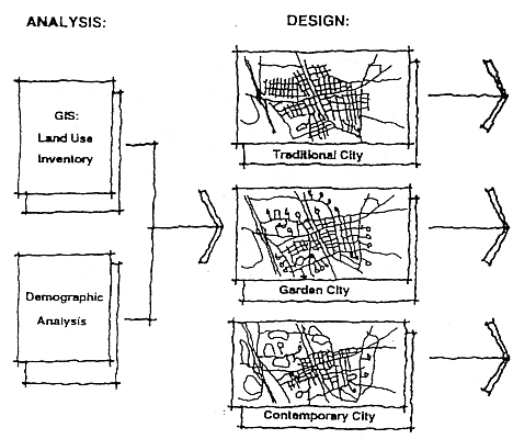
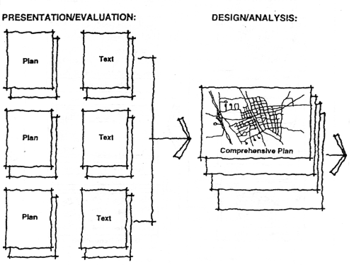
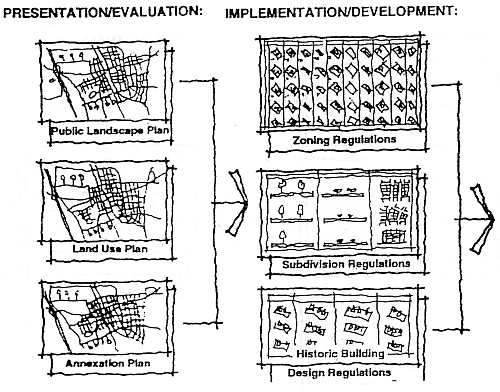
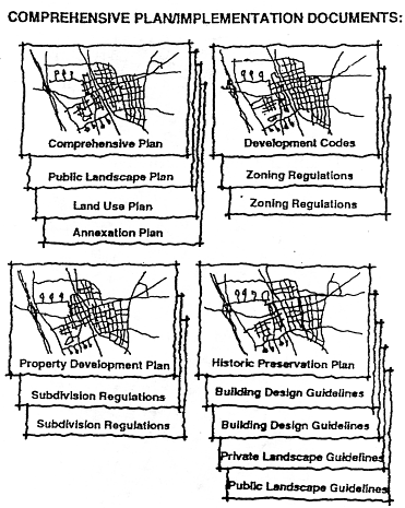
Figure 3A: The Design Alternatives
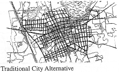
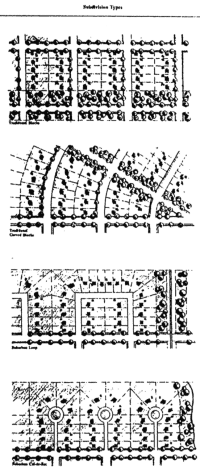
Traditional City. This is a continuation of traditional development practices. It includes a grid system of streets and blocks, with uniform lots, and sometimes alleys. Growth is incremental, but compact. Most commercial and civic buildings are on Main Street, forming a center of the town. A few commercial buildings may be scattered within residential blocks, particularly near Main Street. Civic buildings, such as City Hall, may be in the center of town. Others such as churches, schools, and libraries may be on major streets leading to the center. Most employment is in downtown or in industrial areas located near the railroad. The town does not have a clear boundary, edge, or entry because the grid is expandable in all directions. Agricultural land close to the city could be one day annexed.
Figure 3B: The Design Alternatives
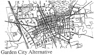
Garden City. The Garden City is a set of ideas meant to reform the traditional city. Those ideas dominated most of the 20th Century and therefore underlie most conventional planning, zoning, and subdivision practices. The street system is hierarchical with cul-de-sacs or loops being the prevalent local street. The town has a center for town-wide functions but it is also divided into neighborhoods to provide identity at the neighborhood scale. Each neighborhood has an elementary school, churches, playgrounds, and maybe a retail center. Most employment is on the periphery of the town, clearly separated from the town's neighborhoods. Civic buildings and large churches often have prominent locations in the town center. The city has a clear entry and defined boundaries, and is ideally surrounded by a greenbelt.
Figure 3C: The Design Alternatives
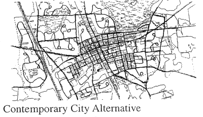
Contemporary City. The contemporary city, reflecting contemporary development patterns, is very different from the first two forms. It is a collection of enclaves--housing, commercial centers, office parks, industrial parks, etc. Those fragmented parts are connected by major streets whose primary function is to allow traffic to flow as freely as possible. Usually, each enclave has only one entrance from a major street. The town would not necessarily have a center and if a center existed historically it would be considered an anachronism. Commercial development, new subdivisions, office parks, and even new civic buildings locate for ease of access, not proximity to one another. The contemporary city has boundaries around every development, entries at each development, and considerable open spaces (usually vacant, undeveloped land) in between. Leap frog development would typify how this city expands outward.
The appendix to this article compares the primary characteristics of each of these visions in a series of tables. These characteristics can be adapted to any small town facing the kind of urbanization pressures that Hahira addressed.
Another issue was the location of future commercial development. The Traditional City alternative was selected to limit commercial development only in the existing downtown area, following the strong preferences in the town survey and by the major and city council. The development patterns characterizing the Contemporary City alternative were found to be appropriate for the area west of Interstate 75 because this territory was clearly highway-related and would be developed separately from the older parts of the city, east of I-75.
| The vision selected was a hybrid (see figure 4). It provides for one major commercial area located in downtown but includes freeway-related commercial uses at the I-75 interchange. The city's existing grid street pattern would become the nucleus of the city and undeveloped land in that nucleus would build streets conforming to the grid. But cul-de-sac/loop, suburban (low density) development would ring the city thereby giving it a defined edge (with open spaces beyond) and preventing future annexations in most cases. Where annexations are considered appropriate, the grid street pattern would extent into them but development of those annexed lands would include cul-de-sacs and loops at their edges to prevent future annexation of land beyond. The city's nucleus would be subjected to site planning and landscaping that would retain the city's close-knit nature but new developments at the city's edge would conform to more suburban design standards (such as larger lots and somewhat wider streets). Yet, all areas of the city would be connected to the center through streets and sidewalks. |
Figure 4: Hahira Town Plan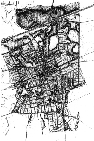
|
ImplementationThe comprehensive plan, public landscape plan, land use plan, and future annexation plan were all placed on 24-inch by 36-inch mylar sheets mounted in City Hall. Copies of each sheet are provided easily and cheaply to anyone who asks. New development regulations were also prepared for Hahira using the same post-board style. Figures 5 and 6 provide an illustration of how zoning and subdivision regulations are conveyed. This approach clearly linked the plan to the implementing ordinances and in most situations a person could visually move one's eye from the most general plan to the most specific regulation affecting a particular property without changing pages or changing scales of maps. The end result of this process is the conversion of planning documents and ordinances into visual form understandable to everyone and the elimination of the thick zoning and subdivision texts that few people, including architects and planners, readily understand.EpilogueThe city of Hahira began implementing the plans and ordinances in 1995. There have been no annexations despite several petitions for such. Several new developments totaling more than 100 housing units have been approved and site planning is consistent with the plans and ordinances. In short, the city is implementing its vision. When it is built out in about 20 years, the city will have more than 3,000 residents and 1,000 workers with little more than the area comprising the current city limits. | Figure 5: Excerpt From Zoning Ordinance (Click Image for Index to Larger Image) 
Figure 6: Excerpt From Zoning Ordinance |
Richard Dagenhart, AICP
Associate Professor of Technology
Georgia Institute of Technology
Edward McKinney
Georgia Institute of Technology
Students
Daryl H. Barksdale, Juan Borrelli, Timothy S. Chapin, Shown P. Dikes, Cynthia Eidson, James Hayes, Mark Hipp, Edward McKinney, Eric Seugling, Lucien L. Tatum, III, Denise M. Wright, and Douglas H.R. Young