
Richard Bolan, Thomas Luce, Hin Kin Lam
Copyright 1997 Bolan, Luce, LamChallenging traditional urban theory, the authors warn that growth boundary strategies are based on outmoded notions of urbanization processes. This paper, using an analysis of the Twin Cities metropolitan region, presents an emerging theory of 'postmodern' urban development based on social restructuring and a physical decentralization to the suburbs. Their research has profound implications for growth management.
The effective management of growth has been a key issue for American urban areas for some time. One tool of growth management that has been gaining in prominence is the use of growth boundaries.(Kelly, 1993, 53-54) Recent mandates in new state legislation for urban growth management, such as the 1991 law passed in the State of Washington, expressly require the imposition of growth boundaries around major urban areas. This paper examines evidence of the effectiveness of this tool as used in the Twin Cities metropolitan region. Our findings indicate that the growth boundary, known as the Metropolitan Urban Services Area (MUSA), has been quite effective. The MUSA line is set by the Twin Cities Metropolitan Council whose jurisdiction covers a seven-county area. However, urban growth has extended beyond those seven counties and our evidence indicates that some leapfrogging development has occurred. Developers have been able to escape the restrictions imposed by the growth boundary, to some extent, by simply going to an adjoining county that does not come within Metropolitan Council jurisdiction.
In this paper we argue that this has both theoretical as well as practical implications for the limitations of growth boundaries as a management tool. In some ways, the notion of growth boundaries reflects an underlying theory of urban development based on urbanization processes of the late 19th and early 20th century. Whether they can really be effective instruments of urban management in the contemporary postmodern global restructuring of economic and social urban geography is an important issue for research and study. This is the primary intellectual issue that has motivated the research described below. In the paper we will: (1)explain the background of our theoretical argument and the hypotheses we seek to test; (2) we then discuss methodology and data sources, (3) from this our findings are explained and (4) finally we suggest some implications for new concepts of urban growth management.
Growth management presupposes understanding and agreement on two factors: (1) a clear vision of the goals of growth management and (2) a clear understanding of the dynamic forces that underlie the processes of urban growth. Often the failure to effectively manage growth can be attributed to a lack of a clear vision of exactly what the goals of such management should be. Equally significant, however, is that growth management policies tend to be based on outmoded understanding of the urban growth processes. This paper addresses this second issue and seeks to postulate new hypotheses for analyzing urban development in the light of efforts to use the management tool of growth boundaries in a single metropolitan area. The need for new conceptual tools arises from the decline of the traditional central city as the primary anchor for urban growth and expansion.
Urban growth has historically been strongly related to transport technology. The reach of development has traditionally been constrained by the available vehicles, rights-of-way, land forms, and the costs of dealing with each. This continues today. However, the transport technology of the last half of the 20th century has been dominated by automobiles and trucks. Not only have the technologies for these vehicles been continually improving but the development of a system of high speed express rights-of-way, as seen in the Interstate Highway program initiated in 1956, has significantly reduced travel times and costs. Even terrain obstacles (rivers, mountains, etc.) have been conquered and land form has almost faded away as a barrier through advances in engineering. In short, all of the constraining variables have been continually loosening. Vehicles are faster, more flexible, and less expensive (if externalities are ignored) and rights of way easily cross rivers and mountain ranges. Today a 50-mile journey can often be readily and safely accomplished in less than an hour. Our transport technology has also become highly individualized (as with water supply, electricity and telephone service) enabling individuals to travel according to their own schedule and needs.
The rights of way supporting autos and trucks have become more ubiquitous and also more differentiated and specialized; today, streets and highways are the integral parts of a multi-level system with linked levels of movement opportunity combined with improvements in engineering and safety.
Thus, 19th century and early 20th century urban centers have become displaced as the anchors for urban growth and expansion. The engine of growth of the past 50 years has been the Interstate highway system that not only connects traditional urban centers together but also vastly improves mobility and access within urban areas. Interchanges allowing easy transfer from high speed elements of the system to localized and lower speed elements are the cross-roads of the late 20th Century. The four corners of the freeway interchange are today's high value locations the real estate hot spots that attract new jobs and new housing complexes.
Traditional urban theory, that postulates urban growth radiating out from a single center (often formed around a port or railhead or other transport advantage), is very much in question today. Traditional theory argues that the competition for central space drives up land values at the center and that there is a diminishing gradient of land values and density of development as one moves away from the center. As development around the center fills in with higher and higher densities, new growth occurs at the periphery. (Mieszkowski and Mills, 1993, 136) A variety of theoretical contributions have contributed explanations based on the assumption of the economically dominant center.F1 1
While accessibility has always been a part of these contributions, it has largely been assumed to be relatively static and attention has focused more on the play of other forces that have encouraged shaping land markets and urban form. We argue, in contrast, that accessibility is a fundamental creator of value in land and the modern ground transportation system has changed considerably in the last two decades. This system is the engine driving today's urbanization process. The interstate highway has become the dominant anchor of urban development and the competition for central land occurs in numerous locations i.e., wherever there is an interchange where the high speed limited access right-of-way is linked to local rights-of-way.
Freed of the dominance of the traditional center, the urbanization process involves multiple cross-roads; numerous centers and a host of main streets still somewhat anchored to an existing historical center but increasingly becoming less dependent on it and more linked to anywhere the auto and truck can go. Urban development can now stretch far into the hinterland people can realize their dream of their own home on their own land with privacy and protection from unwanted neighbors and still be accessible to shopping malls, urban careers, diverse recreation and diverse social contacts (with less dependence on immediate neighbors for social relations). (Downs, 1992, 1994) In short, in keeping with Ebenezer Howard, they can marry Town and Country at relatively low cost to themselves (there may be of course great costs to society). (Howard, 1965) The emergence of edge cities has involved the decentralization of jobs and population but their anchor is invariably a limited access expressway. (Garreau, 1991)
A recent study of Houston lends support to this notion. The authors, working from detailed land use data, analyzed net densities (the actual land on which residences were built) and found that in some instances, net residential densities actually increased with distance from the center. (Mieszkowski and Smith, 1991, 184) The authors also note:
In Houston's case, the development of freeways increased density along the freeways and decreased density in suburban locations away from the freeways. Land considerably distant from freeways or circular roads that provide access to the freeways tends to remain vacant, while land close to the freeways, but 10-15 miles further out, is developed. (Ibid., 193)
Studies of housing values in the Los Angeles region indicated that values rise not only with proximity to job centers (of which many were identified, not just the downtown) but also with access to amenities (such as coastal locations). (Heikkila, et. al., 1989). The urban realm, in short, is becoming liberated from a dominant central business district enabled by a modern transportation system where the costs of overcoming space are becoming lower and lower (Friedmann and Miller, 1965).
These ideas are beginning to be reflected in what might be called an emerging theory of postmodern urban development. The key conceptual components are:
Planning tries to regulate these processes through growth management. Historically, the traditional tools for doing this have included: zoning, building codes, official maps, subdivision regulations. Today the instruments of management have expanded and include environmental regulations, exactions, impact fees, performance standards and the like as well as more subtle fiscal techniques. One of the newest techniques has been the imposition of growth boundaries beyond this line the city shall grow no more.
The Twin Cities is one of a number of urban areas that have adopted growth boundaries as a way to contain sprawl. (Kelly, 1993) For the Twin Cities, the agency responsible for the use of the growth boundary as a regional policy tool is the Metropolitan Council. The Council is a state agency that was established in 1967 with 16 councilors appointed by the Governor and representing legislative districts contained in an area made up of seven counties. The Council formulated its first development strategy in 1975 and the implementing legislation for the growth boundary was passed in 1976. (Martin, 1993) In our analysis below, we examine population growth trends in the two decades: 1970 to 1980 and 1980 to 1990. Thus the policy implementing the growth boundary was in effect for only a short time during the first decade of growth that we examine. For the 1990 Census, the Census Bureau redefined the metropolitan area by adding four adjacent northern counties in Minnesota and two counties across the state line to the east in Wisconsin. F2 Thus, in the eyes of the Bureau of the Census, the urban region is now a two-state area that has grown beyond the reach of the Metropolitan Council's jurisdiction.
The growth boundary is a line that determines the outward extent of the metropolitan sewer, roads and parks systems and is shown on the map contained in Figure 1 together with its relation to the seven county boundary and the major highway system. New development is intended to take place within the boundary so that the new land uses are served as much as possible by existing infrastructure capacity. Beyond the boundary, the intent is to keep densities low enough so as to permit the preservation of agricultural land, the safe use of private wells and septic systems, and the avoidance of undue capital investment in new public infrastructure. Under Minnesota law, the Council carries this out through a review and approval process of plans prepared by local government jurisdictions (counties, municipalities, school boards and special districts). The Council can require modification of local plans if it finds that they have an impact on the regional public systems noted or if they do not conform to the Council's policies respecting these metropolitan services. F3 The goal of the growth boundary is well expressed in its official name: the Metropolitan Urban Services Area (MUSA).
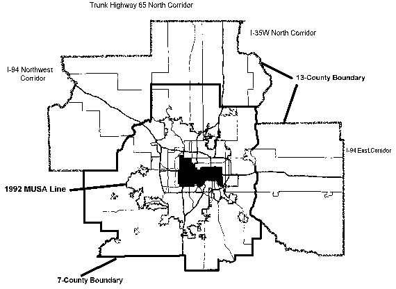
Clearly, the MUSA line is based on an assumption about the nature of the urban development process that is closely aligned with the traditional concept of a concentrated center (in this case two distinct but closely located central business districts). It bears relatively little relation to the federal interstate highways that bisect the area, but tends to represent a circular expansion of historical development patterns. While the boundary was first established in 1976, it has been amended and added to on numerous occasions since then. In this paper, we examine the patterns of urban growth in the metropolitan area, given the existence of a growth boundary for twenty years. The paper, however, restricts itself to analyzing the growth patterns from the MUSA line outward to the six counties newly added by the Bureau of the Census.
Our hypothesis is that growth has been driven by the Interstate Highway System constructed between 1958 and 1978 combined with the contemporary forces of a postmodern, globalizing economy. This system has loosened the linkages to the previously dominant and abutting core cities of Minneapolis and St.. Paul. In the past 20 years, the modern system has been laid over the original development pattern so that the urban area of 1960 was bisected north and south by Interstate I-35 and bisected roughly east and west by I-94. F4 Our approach to analyzing the evidence employs a cross-sectional profile of growth patterns of population and jobs along the interstate highway corridors. These are contrasted with the growth pattern of a local trunk highway that runs north of the urban area while parallel and about 11 miles west of an interstate.
As noted, the centerpiece of analysis lies with the cross-sectional profiles along the interstate freeways that bisect the urban area. The focus of attention is an examination of the patterns of change that have occurred in the corridors that reach out into the six counties newly added to the definition of the metropolitan area by the Bureau of the Census. Consequently, in the analysis we are examining four distinct corridors radiating out from the two central cities:
We have examined population changes at the municipal (or minor civil division) level using data from 1970, 1980 and 1990 Census of Population. Employment changes are reflected in covered employment data developed in the County Business Patterns of the Department of Commerce for 1981, 1987 and 1993 using the postal zip code as the geographical base. The analysis looks at both changes in absolute terms and terms of changes in density. We have used a density measure that squares with the historical pattern of surveying for the original federal land grants in the 19th Century and which has formed the base for the formulation of municipal boundaries the 40-acre section. Many present zoning regulations beyond areas of urban development express density regulations in terms of the 40-acre section.
Tables 1 through 3 and Figures 2 through 9 present the population and employment data in several ways.. The Tables show data for the corridors aggregated into five zones within each of the corridors to examine overall trends. The Figures show growth patterns at the jurisdiction level to reveal whether the aggregated data conceal important trends at that more detailed level of analysis.
Tables 1 and 2 show population growth, measured in absolute numbers and densities respectively, broken out by the corridors and by zones within the corridors for the 1970s and 1980s. The breakdowns are designed to show the extent to which the MUSA line has directed growth within the seven county area regulated by the Metropolitan Council as well as the extent to which growth pressures have pushed development beyond the seven county area ( leapfrog growth ). The corridors are each divided into five zones: (1) the area within the MUSA line where the Metropolitan Council regional growth policy intends for most growth to occur; (2) the area between the MUSA line and the seven county boundary where growth is meant to be restricted; (3) the first ten miles beyond the seven county border where one would expect most leapfrog development to occur; (4) the area in the next ten miles beyond the seven county boundary; and finally (5) the area beyond twenty miles from the seven county boundary extending to the 13-county boundary. In general, we analyzed each corridor for a distance of roughly between 10 and 50 miles from the two central cities. F6
|
|
Corridor |
|||||
|
|
Metro Area |
Total |
I-94 E |
I-94 W |
I-35 N |
Mn65 N |
|
|
|
|
|
|
|
|
|
Total Growth: 1970-1980 |
142,662 |
160,135 |
20,074 |
66,480 |
38,950 |
34,631 |
|
Inside MUSA |
|
99,849 |
10,113 |
45,069 |
26,248 |
18,419 |
|
Between MUSA and 7-county line |
|
22,939 |
2,411 |
5,172 |
4,401 |
10,955 |
|
0-10 miles outside 7-county line |
|
27,172 |
5,852 |
11,611 |
5,955 |
3,754 |
|
10-20 miles outside 7-county line |
|
8,343 |
1,008 |
3,562 |
2,437 |
1,336 |
|
> 20 miles outside 7-county line |
|
1,832 |
690 |
1,066 |
-91 |
167 |
|
|
|
|
|
|
|
|
|
Total Growth: 1980-1990 |
333,700 |
178,006 |
24,414 |
68,660 |
42,213 |
42,719 |
|
Inside MUSA |
|
137,670 |
16,636 |
50,230 |
35,894 |
34,910 |
|
Between MUSA and 7-county line |
|
9,734 |
802 |
1,572 |
1,853 |
5,507 |
|
0-10 miles outside 7-county line |
|
23,998 |
6,210 |
12,044 |
3,088 |
2,656 |
|
10-20 miles outside 7-county line |
|
5,755 |
770 |
4,367 |
1,096 |
-478 |
|
> 20 miles outside 7-county line |
|
849 |
-4 |
447 |
282 |
124 |
Source: 1970, 1980 and 1990 Census of Population.
1. Population and growth data for I-94E and I-35N exclude four municipalities. See footnote, Section 3.
|
|
Corridor |
||||||||||
|
|
Total |
I-94 E |
I-94 W |
I-35 N |
Mn65 N |
||||||
|
|
|
|
|
|
|
||||||
|
Total Growth: 1970-1980 |
4.3 |
2.4 |
6.9 |
3.7 |
4.1 |
||||||
|
Inside MUSA |
15.4 |
8.9 |
28.9 |
11.4 |
12.1 |
||||||
|
Between MUSA and 7-county line |
3.5 |
2.7 |
3.6 |
2.3 |
4.8 |
||||||
|
0-10 miles outside 7-county line |
2.3 |
2.5 |
3.0 |
2.0 |
1.6 |
||||||
|
10-20 miles outside 7-county line |
1.0 |
0.6 |
2.0 |
0.8 |
0.6 |
||||||
|
> 20 miles outside 7-county line |
0.5 |
0.3 |
1.1 |
-0.2 |
8.7 |
||||||
|
|
|
|
|
|
|
||||||
|
Total Growth: 1980-1990 |
4.8 |
2.9 |
7.1 |
4.0 |
5.1 |
||||||
|
Inside MUSA |
21.2 |
14.7 |
32.3 |
15.6 |
23.0 |
||||||
|
Between MUSA and 7-county line |
1.5 |
0.9 |
1.1 |
1.0 |
2.4 |
||||||
|
0-10 miles outside 7-county line |
2.1 |
2.6 |
3.1 |
1.0 |
1.1 |
||||||
|
10-20 miles outside 7-county line |
0.7 |
0.4 |
2.4 |
0.4 |
-0.2 |
||||||
|
> 20 miles outside 7-county line |
0.2 |
-0.0 |
0.4 |
0.5 |
6.4 |
||||||
Source: 1970, 1980 and 1990 Census of Population.
1.Population and growth data for I-94E and I-35N excluded four municipalities.See footnote, Section 3.
The tables and charts also show the 1970s and 1980s separately. This is important because the MUSA line was not implemented until the second half of the 1970s. This means that growth in the 1970s was relatively unrestricted, regulated only by local government zoning with no imposed regional policy. This provides a benchmark for evaluating the effects of implementation of the MUSA boundary.
Tables 1 and 2 show that, overall, each of the four corridors grew steadily over the period, adding 160,135 people in the 1970s (4.3 people per 40 acres) and 178,006 (4.8 per 40 acres) in the 1980s. The growth in the 1970s in these corridors actually exceeded total growth in the thirteen county region during this period by 12%, implying that these corridors were regional hot spots during that period. F7 This was less true in the 1980s but the corridors were still very important contributors to regional growth, representing 53% of total population increase in the region. Each corridor grew by a bit more in the 1980s than in the 1970s the distribution of growth across the corridors was roughly the same in the two decades.
However, the distribution of growth within the corridors changed in very important ways during the two decades. During the 1970s when growth was relatively unregulated in terms of regional policy until late in the decade, the innermost three zones showed substantial growth overall in each of the corridors. In particular, the area between the MUSA line and the seven county boundary (that was later heavily regulated in the 1980s) grew significantly in the 1970s in each of the corridors. On average, this zone absorbed 19% of the growth that occurred in the corridors to the seven county boundary (22, 939 out of 122,788).
To control for variation in area, we measured the change in density from 1970 to 1980 (Table 2). Zones lying within the seven county boundary outgrew the zones outside in each individual corridor as well as in all four corridors combined. Indeed, Table 2 shows that in each of the corridors, growth in the 1970s (measured as a change in density) declined with distance from the center of the region exactly the expected declining gradient pattern of density changes that one would expect to see in an unregulated urban land market under the traditional theoretical framework. F8
The pattern between 1980 and 1990 is markedly different. The major difference is found in the areas within the (regulated) seven county area. Growth in the area between the MUSA line and the seven county boundary was greatly curtailed, to less than 45% of the amount that occurred in the 1970s (9,734 compared to 22, 939). At the same time, growth inside the MUSA confines increased substantially. Thirty-eight percent more people were added within the MUSA boundary in the 1980s than in the 1970s overall (137,670 versus 99,849) and the share of growth within the seven county boundary that occurred in the regulated zone outside the MUSA dropped to just 7% (from 19% in the 1970s). The sharp reduction in growth in the restricted zone was clearly not the result of a lack of demand for land within the seven county boundary in the corridors. The strong implication is that the MUSA line had its intended effect on growth patterns in these parts of the corridors growth was largely directed within the MUSA zone and away from the outer parts of the seven county area regulated by the Metropolitan Council.
Did the MUSA fulfill this role without the expected costs in the form of leapfrog development? The data for the areas outside the seven county suggest that the MUSA did not significantly increase the demand for land just outside the regulated zone in any drastic way. Overall, there were fewer people added to each of the zones outside the seven county area in the 1980s than the 1970s. For instance, in the first 10-mile zone outside the seven county area, only 23,998 people were added in the 1980s (2.1 people per forty acres) compared to 27,172 (2.3 people per forty acres) in the 1970s. The pattern differed somewhat across the corridors in two of the four corridors, there were small increases in the numbers of people added in the zones just outside the seven county area but none of the corridors shows a distinct increase in the rate of development in the zones beyond the seven county boundary. Indeed, only the I-94 northwest corridor added more people in total outside the seven county area in the 1980s than in the 1970s and the increment was only about 4%.
We cannot say with certainty of course that this means that the MUSA line has not caused significant leapfrogging because we cannot predict with certainty what growth patterns would have been in the absence of the MUSA line. In addition, there is anecdotal evidence to suggest that leapfrogging has increased in the six years since 1990. However, the aggregated population data between 1970 and 1990 do not support the notion that the MUSA line increased leapfrogging as a problem in the corridors and time periods covered by the data in Tables 1 and 2.
|
|
Corridor |
|||||
|
|
Metro Area |
Total |
I-94 E |
I-94 W |
I-35 N |
Mn65 N |
|
1981 Jobs |
1,366,966 |
210,802 |
29,602 |
73,524 |
78,507 |
29,169 |
|
|
|
|
|
|
|
|
|
Total Growth: 1981-1993 |
269,216 |
126,153 |
12,396 |
64,486 |
34,632 |
14,639 |
|
Inside MUSA |
|
105,776 |
7,687 |
52,421 |
31,215 |
14,453 |
|
Between MUSA and 7-county line |
|
6,266 |
593 |
4,498 |
1,119 |
56 |
|
0-10 miles outside 7-county line |
|
11,835 |
3,953 |
6,112 |
1,576 |
194 |
|
> 10 miles outside 7-county line |
|
2,276 |
163 |
1,455 |
722 |
-64 |
|
|
|
|
|
|
|
|
|
1981 Jobs per 40 Acres |
|
5.7 |
3.5 |
7.6 |
7.4 |
3.5 |
|
|
|
|
|
|
|
|
|
Total Growth: 1981-1993 |
|
2.5 |
1.0 |
5.1 |
2.4 |
1.3 |
|
Inside MUSA |
|
12.9 |
6.7 |
32.1 |
10.3 |
6.0 |
|
Between MUSA and 7-county line |
|
0.7 |
0.6 |
2.3 |
0.3 |
0.0 |
|
0-10 miles outside 7-county line |
|
0.7 |
0.8 |
2.4 |
0.4 |
0.0 |
|
> 10 miles outside 7-county line |
|
0.1 |
0.0 |
0.2 |
0.2 |
-0.1 |
Source: County Business Patterns
Table 3 shows similar data for employment growth in the corridors between 1981 and 1993. Unfortunately, data limitations prevent comparison of this period with an earlier time period, before imposition of the MUSA line. However, the data show that employment growth in the later period was even more concentrated within the MUSA line and the seven county area than population growth. 84% of job growth during the period (105,776 out of 126,153) occurred within the MUSA line (compared to 77% for population growth in the 1980s) and just 11% of job growth occurred outside the seven county area (compared to 17% for population). The overall pattern is even more pronounced in the density data in the bottom panel of Table 3. Job growth per 40 acres was very much lower in all of the zones outside the MUSA line than within the MUSA line in each of the corridors. Overall, the employment data imply that the MUSA line appears to be serving its primary function of concentrating growth within the serviced area. To some extent this is expected. The evidence is that jobs did indeed move to the suburbs in great numbers during the period, but these movements all occurred within the area for which sewer and other metropolitan services were available. Thus, there is no evidence of significant leapfrogging of commercial and industrial development beyond the seven-county boundary.
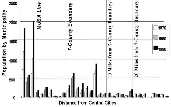
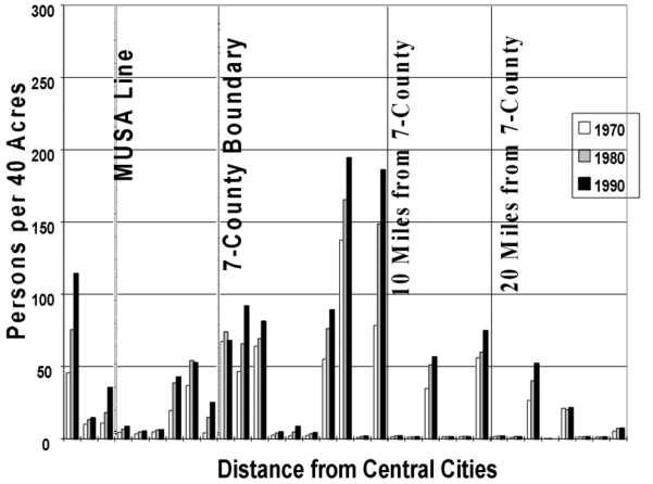
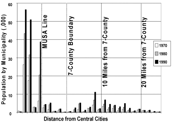
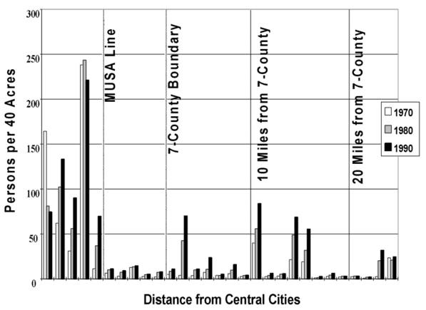
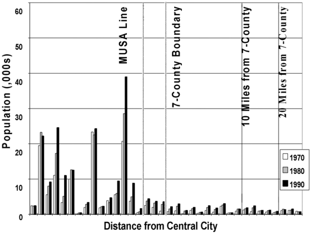
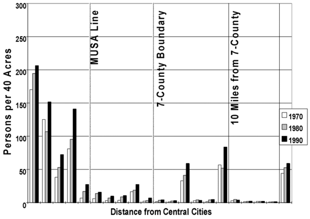
Figures 2 through 9 provide more detail about population changes within the corridors. The bar charts array the 1970, 1980 and 1990 jurisdiction-level population (Figures 2, 4, 6 and 8) and population density (Figures 3, 5, 7 and 9) by distance from the center of the region for each of the corridors. They are meant to reveal whether the aggregated data in Tables 1 and 2 obscure important patterns at the jurisdiction level. For instance, it is important to know whether a relatively small increase in population or density for the first ten miles outside the seven county boundary as a whole hides a sharp increase right at the boundary that is offset by smaller increases farther out. In general, the figures suggest that this is not the case but the findings are more ambiguous than in Tables 1 and 2.
Figures 2 and 3 show the data for the I-94 East corridor. The chart shows some relatively densely settled areas within the regulated zone from the MUSA line to the seven county boundary and just beyond the seven county boundary, suggesting that the MUSA policy may not be doing all that it should at the local level. However, several factors mitigate against this conclusion. The high density towns in the restricted zone are a group of very small communities clustered on the St.. Croix River. These communities are small with populations less than 1,000 in most cases (see Figure 3) but with even smaller acreage delineated by their municipal borders (from 250 to 650 acres). In addition, any density increases that occurred in the restricted zone happened during the 1970s prior to full implementation of the MUSA line and two of the three cities actually showed a decline in density between 1980 and 1990. Similarly, the high density towns just outside the seven county boundary are relatively small and the density increases that one sees in this zone are greatest in the outer parts of the zone, especially in River Falls, Wisconsin, the largest town (at roughly 9,000 people in 1990). However, even with these mitigating factors in mind, the chart does show a relatively clear pattern of high and increasing population densities in the area just beyond the scope of Metropolitan Council land use regulation, implying that the limited scope of the Metropolitan Council's authority has resulted in some leapfrogging in this corridor. F9
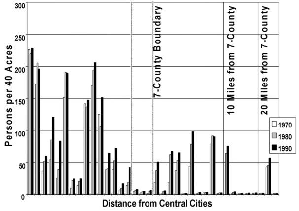
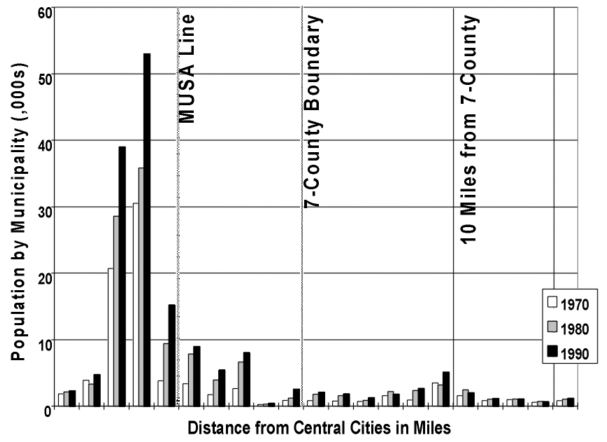
Figures 4 and 5 show the jurisdiction level data for the I-94 West corridor. The picture in this corridor is more clear-cut than for I-94 East. Figure 4 shows high and increasing densities within the MUSA line, low and stable densities in the regulated zone just beyond the MUSA line and then pockets of moderate and increasing densities beyond the seven county border. The evidence for leapfrogging is a bit stronger in this corridor in that the high and increasing density places in the zone are also the more populous towns in these areas (see Figure 5). However, their absolute sizes in 1990 fall in a range from only 2,500 (St.. Michael) to 6,850 (Buffalo). In general, the disaggregated data for this corridor show some reasons for concern regarding leapfrogging but not on a massive scale.
Figures 6 through 9 show the two northern corridors. The patterns in these areas are similar to the I-94 W chart high and increasing densities within the MUSA line, lower and stable densities in the regulated zone and small pockets of high density outside the seven county boundary. However, with the exception of Cambridge, the hot spots in these outer zones are still small (each with less 2,500 people in 1990) and show little or very moderate growth in the 1980s. Consistent with Table 2, leapfrogging seems to be less of a concern in these corridors to the north.
Overall, the jurisdiction level population data show a bit more reason for concern about leapfrogging than the aggregated data. However, in none of the zones does it appear to be occurring on a scale great enough that it could be said to have undermined the overall impact of the MUSA line as of 1990.
Jurisdiction level compilations of the employment data reveal no patterns beyond what is seen in Table 3. Employment and employment growth were highly concentrated within the MUSA line between 1981 and 1993 with only a very few spots with significant densities outside the growth boundary.
There are several useful directions for future work in this area. First, it is worth examining the nature of growth both within and beyond the area regulated by the Metropolitan Council and the MUSA line. We plan to continue work in this area by examining the characteristics of the jobs and population moving outward in the Twin Cities, especially into the areas beyond the purview of the Metropolitan Council. Is leapfrog residential development targeted primarily toward the high end of the income distribution as the stereotypes imply or is there a significant moderate to low income component? The answer to this question has important implications in several public and social dimensions, including things like the capacity of the land to accommodate new growth not served by existing sewer and water treatment infrastructure. On the jobs side of the labor market, what types of jobs are most likely to be moving to the fringes of metropolitan areas? And do the jobs correspond in any way with the types of workers who are making the same moves? These questions have important implications for the capacity of transportation systems to accommodate new commuting patterns as they emerge.
The capacity of public institutions to evolve in response to the kinds of growth that we see in metropolitan areas is another area worthy of more attention. One of the chief motivations for the research reported in this paper was concern regarding the limited purview of the Metropolitan Council as well as the limited capacities of jurisdictions beyond the Council's area of influence. The Council's current borders are limited in ways that make the potential for expensive leapfrog development much greater in the future than in the past. Yet current politics in Minnesota would seem to preclude any expansion of the Council's sphere of influence. New ways for metropolitan authorities to cooperate with the areas just beyond their boundaries are needed. We plan to pursue most of these avenues of research in the near future.
Growth patterns in the Twin Cities in the wake of implementation of the MUSA line imply that growth boundaries have the potential to significantly affect the pattern of population and employment growth within a metropolitan area. Population growth patterns within the four corridors examined in this work differed sharply in the period after the implementation of the MUSA line (the 1980s) from those before (the 1970s). The data imply that the MUSA line sharply curtailed growth in the regulated zone outside the boundary as it was intended to do, directing growth to the serviced areas within the boundary.
The data also imply that up until 1990, growth pressures had not resulted in large amounts of leapfrog development beyond the regulated zone between the MUSA line and the seven county boundary representing the limits of Metropolitan Council authority. However, the data show some patterns suggestive of problems in the future as growth pressures become more severe, or, similarly, as the location of the MUSA line moves closer and closer to the boundary of Metropolitan Council influence. Two of the four growth corridors showed signs in the 1980s of leapfrogging problems that can only have gotten worse in the 1990s. The region has continued to grow since 1990, experiencing only a very minor recession in 1991, and anecdotal evidence abounds of an increasing incidence of leapfrog development. The Metropolitan Council has reacted to this by adopting a new development strategy that would significantly expand the area within the MUSA line. However, one effect of this is simply to push the MUSA line closer to the relatively unregulated areas outside the Metropolitan Council region, increasing the proximity of whole new areas outside the seven county area to jobs and population and making leapfrog development that much easier and less expensive.
It is very unlikely that the Metropolitan Council's area of influence will be expanded in future years. Yet there is evidence to suggest that the use of a growth boundary in the future not be as effective as it has been for the past twenty years. Under the conditions of postmodern urban growth, question arises as to what criteria should be used in drawing a new boundary as pressures to push the present boundary closer to the jurisdictional confines increase. Question also arises as to whether any boundary can really contain urban growth. The clear implication of this is that regional agencies such as the Council and state governments will be pushed to find other means to manage urban growth or face a period of accelerated sprawl as development makes the now less challenging leap over the zone where the council limits growth. This clearly has serious implications on the future demand for public infrastructure. If urban areas truly want to direct growth inward toward areas already served by extensive public infrastructure, they must find additional tools in addition to the use of growth boundaries.
In general, our hypothesis that the interstate highway facilities in the metropolitan area are the engines of new growth was not strongly evident in terms of their generating new linear urban form more distant from the older centers. In part, this may reflect appropriate judgments about where to draw the growth boundary line in 1976 based on expected growth and demand for land over the twenty years that have transpired. There is current pressure today, however, to push the line further out on the grounds that land within the MUSA line has become in very short supply and prices are being unduly driven up by the inability to develop land immediately beyond. Indeed, the Metropolitan Council has recently indicated their intent to expand the MUSA area.
Containing development within the growth boundary, however, has not necessarily solved the problems of the postmodern urban era for the Twin Cities. A considerable share of the growth of the 1980s took place in what Orfield has termed the fertile crescent a zone stretching along the perimeter interstate freeway I-494 starting at the Twin Cities International Airport and extending west to Eden Prairie and then north to the City of Maple Grove (including the eastern portion of our I-94 northwest corridor). A portion of this area has been specifically identified by Garreau (1991) as an edge city. Parts of Dakota County in the southeast also grew rapidly during this period. In each instance, while metropolitan public services have been able to accommodate demands, services provided locally, such as schools and local streets, have placed increasing pressures on local governments resulting in increasing local tax burdens.
In short, a growth boundary is a partial planning and management tool that has proven effective in this instance. It is not clear that it will continue to be an effective tool in the near future.
Adams, Terry. 1992. Census of Population and Housing, 1970 United States: Extract Data File. Ann Arbor, MI: Inter-university Consortium for Political and Social Research.
Alonso, W. (1964). Location and land use: toward a general theory of land rents. Cambridge, MA: Harvard University Press.
Berry, B.J.L. and Garrison (1958). Recent Developments of Central Place Theory, Papers and Proceedings of the Regional Science Association, 4, 107-120.
Downs, A. (1994). New Visions for Metropolitan America. Washington, D.C.: Brookings Institution; and Cambridge, MA: Lincoln Institute of Land Policy.
Downs, A. (1992). Stuck in traffic: coping with peak-hour traffic congestion. Washington, D.C.: Brookings Institution and Cambridge, MA: Lincoln Institute of Land Policy.
Freidmann, J. and J. Miller (1965). The Urban Field, Journal of the American Institute of Planners, 31:4, 312-320.
Garreau, J. (1991). Edge Cities: Life on the New Frontier. New York: Macmillan.
Heikkila, E., P. Gordon, J.I. Kim, R.B. Peiser, H.W. Richardson (1989). What Happened to the CBD-Distance Gradient: Land Values in a Polycentric City, Environment and Planning A, 21, 221-232.
Hoover, E.M. (1948). Location of Economic Activity. New York: McGraw-Hill Book Co., Inc.
Howard, E. (1965). Garden Cities of Tomorrow. London: Faber and Faber, Ltd. (originally published in 1902).
Isard, W. (1956). Location and Space Economy. New York: John Wiley and Sons, Inc. and the Technology Press.
Kelly, E.D. (1993). Managing Community Growth: Policies, Techniques and Impacts. Westport, CT: Praeger Publishers.
Losch, A. (1954). The Economics of Location. New Haven: Yale University Press.
Martin, J. (1993). In Fits and Starts: The Twin Cities Metropolitan Framework, in Metropolitan Governance: American/Canadian Perspectives, Vol. One, edited by D. Rothblatt and A. Sancton. Berkeley, CA: University of California Institute of Governmental Studies Press, Chapter 5, 205-243.
Mieszkowski, P. and B. Smith (1991). Analyzing Urban Decentralization: The Case of Houston, Regional Science and Urban Economics, 21:2, 183-200.
Mieszkowski, P. and E.S. Mills (1993). The Causes of Metropolitan Suburbanization, Journal of Economic Perspectives, 7:3, 135-147.
Mills, E.S. (1972). Studies in the Structure of the Urban Economy. Baltimore: The John Hopkins University Press.
Soja, Edward W. (1995). Postmodern Urbanization: The Six Restructurings of Los Angeles, in Postmodern Cities and Spaces, edited by Sophie Watson and Katherine Gibson. Cambridge, MA: Basil Blackwell, Inc., Chapter 9, pp. 125-137.
U.S. Census Bureau. 1993. Census Transportation Planning Package, Urban Element. Technical documentation. Washington, D.C.: U.S. Government Printing Office.
U.S. Census Bureau. 1994. County Business Patterns 1994: Minnesota. CBP-94-25. Technical Dcumentation. Washington, D.C.: U.S. Government Printing Office.
Wingo, L. (1961). Transportation and Urban Land. Washington, DC: Resources for the Future.
Richard S. Bolan, AICP, is Professor of Planning and Public Affairs and Director of the Master of Planning Program at the Humphrey Institute, University of Minnesota.
Thomas F. Luce, Jr., is Assistant Professor of Planning and Public Affairs at the Humphrey Institute, University of Minnesota.
Hin Kin Lam is a Research Assistant and graduate student at the Humphrey Institute, University of Minnesota.
Preparation of this paper was supported by funds from the Minnesota Extension Service,University of Minnesota; the Center for Urban and Regional Affairs, University of Minnesota; the Center for Transportation Studies, University of Minnesota; and a Ford Foundation collaborative research grant to the Humphrey Institute, University of Minnesota
1 Historically these have included: Hoover, 1948; Isard, 1956; Berry, 1958; Alonso, 1964; Mills, 1972; among others.
2 The addition of these counties were based largely on the criteria of commuting patterns.
3 The Council's authority is derived from the Metropolitan Land Planning Act, Minn. Stat. Sec.473.121.
4 I-94 connects the Twin Cities with Chicago and Madison, WI, to the east and the Fargo-Moorhead area to the northwest (and eventually Seattle), passing through St.. Cloud, MN. Interstate I-35 begins in the north at Duluth, MN and continues south through the Twin Cities to Des Moines, Kansas City and eventually San Antonio, TX.
5 The Metropolitan Council designated outlying cities as Free Standing Growth Centers and drew MUSA lines around these. These centers were located in two of the corridors: I-35 (the Forest Lake area) and I-94 east (the Stillwater area). These centers were excluded from the analysis to allow us to examine the overall growth patterns in relation to distance from the two central cities.
6 Our inner boundary generally included municipalities and zip codes that were traversed by the interstate ring road I-694 on the north and I-494 on the east and west. These freeways lie generally 10 miles from the two downtowns and divide the older inner suburbs of the region from the newly developing suburbs.
7 Minneapolis and St.. Paul actually lost population during the 1970s. Thus. The net change for these four corridors actually exceeded the net change for the whole 13-county area as Table 1 shows.
8 The only exception to the pattern is the outermost zone of the Trunk Highway 65 corridor which contains less than 1,000 acres.
9 There is considerable evidence of growth since 1990 in both population and jobs just across the St.. Croix River in the vicinity of Hudson, Wisconsin.