
|
|
|||
|
|
Watersheds and the Design of Regions: The South Dade Watershed Project |
||
| Daniel Williams FAIA | |||
| Session: Sunday, April 16, 2000, 4:00 - 5:15 p.m. | Author Info | ||
South Florida is running out of land and water. The future of growth and development is clearly limited by both the availability of land and the availability of water.
Introduction
Water is an essential renewable resource that is in constant danger of overuse. The following is an explanation of a planning project done for the South Florida Water Management District. The objective of the South Dade Watershed Project was to analyze the relationship between water and land use, to establish consensus with stakeholders, and to establish regional planning criteria that would assure a sustainable water supply and protection of species in the Everglades National park and the Biscayne Bay, while improving urban, agricultural and natural systems for south Dade County, Florida.
The impacts from non-renewable fuels such as fossil fuel have been revealed in significant ways: inflation, higher taxes, energy and fuel shortages, and water scarcity. They have been revealed even more significantly in the breakdown of whole biological systems.
To achieve an interactive network of humanity and nature—a landscape that has a "place" for both the needs of humans and the functions of nature—requires that planning and design reorient from using to a view that there are limits. It then becomes the combined mission of science, planning, and design to discover these limits and work within them. To put "form" to a common vision and develop incremental strategies on how to get from here to there.
What then are the critical elements in the South Florida landscape that must be taken into account to avoid calamity? What must be repaired and protected to prevent the continued decline in environmental quality and community quality of life? Once this information is gathered, it can be applied to how development and the environment can be incorporated into one system—what must be undone, and what must be added.
The Process
Biourbanism incorporates the natural system sciences of the region into the urban and regional, improving the urban, agricultural, and natural system functioning.
The Pre—1900 Pattern image is consolidated from the information on the 1943 Davis Vegetation Map—this depicts areas of well-drained and poorly drained soils. The dark (black) areas, representing the "higher" well-drained soils of the coastal ridge, are more suitable for development and will remain out of harms way and sea level rising. The lighter areas, representing the "lower" poorly drained soils of the Everglades, the transverse glades, and coastal marsh, tend to flood and are consequently not suitable for development. Of equal importance is this area’s ability to store water for future use and to reduce impacts from drought.
The Smart Growth Areas Map illustrates how the land and water interact naturally in South Dade. The lighter areas represent the areas located along the coastal ridge that are at elevations above the 100-year flood plain. The stormwater flows off the coastal ridge, from areas of higher land elevation, to areas of lower land elevation. This water eventually flows to the drainage canals and ultimately Biscayne Bay. The areas, located on either side of the coastal ridge, are open pervious/porous areas that provide critical water recharge to the Biscayne Aquifer.
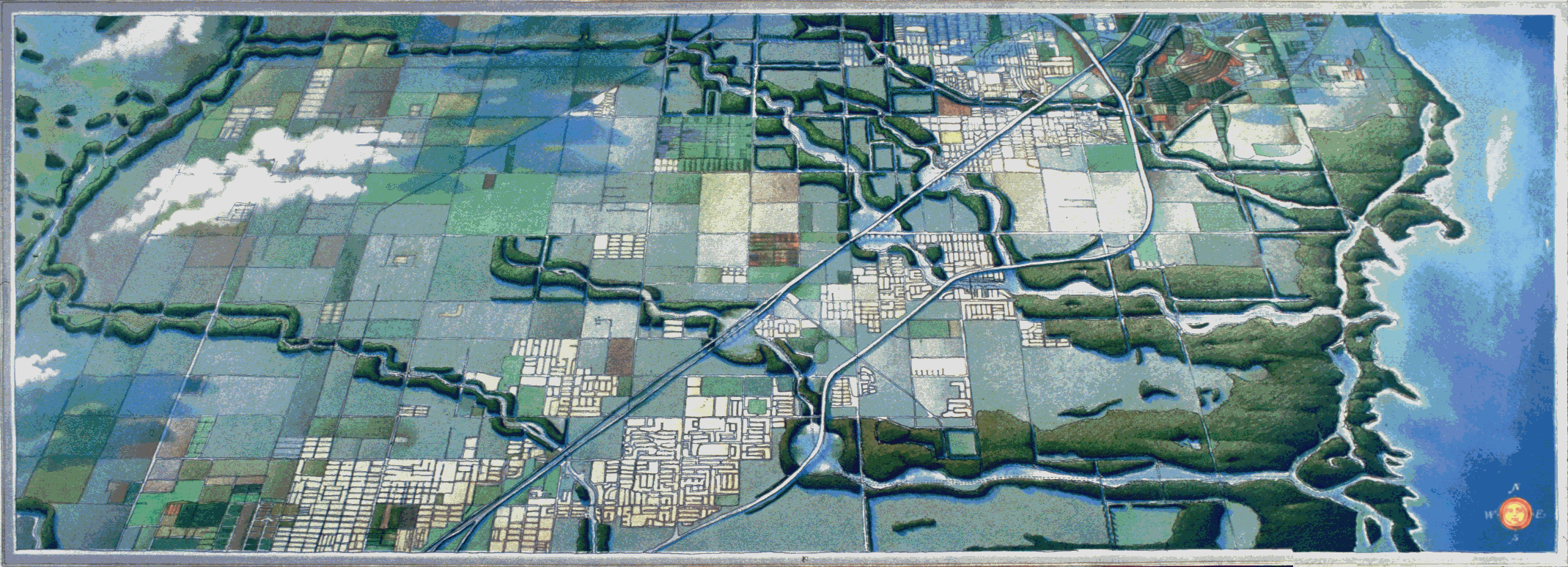
The Systems Conflict Map also overlays the 100-year flood plain on the existing development grid. As can be seen, much of the recent development in South Dade has occurred in areas that are less suitable for development. In that these areas are becoming more developed for urban uses the flooding criteria is changing. Once the groundwater has been lowered there will be a significant reduction in regional storage. To combat this, new areas need to be used for regional recharge. This image suggests that these new areas include historic Everglades wetlands, valuable coastal marshes, and critical recharge areas for public wellfields. Continued development within these areas, which is the present-day pattern, will cause more local flooding, eliminate critical aquifer recharge areas, and destroy valuable natural resources.
Given the limited land area that is suitable for development and the water resource limits of South Dade, how do we create a system that will insure the viability and hydrology—and our knowledge of their interactive connections? We can re-create the historic hydrologic functions of the region.
This approach, illustrated in Sustainable South Dade image, is designed to use the "free work" of nature to efficiently collect, store, clean-up, and distribute water for all users—urban, agricultural, and natural systems.
The Smart Growth Plan shows the drainage canals replaced by broad wetland systems similar to what was historically "the transverse glades". These topographic low points are an integral part of the region’s natural flood protection. The north-south canal, separating the developed part of Dade County from the Everglades, is expanded to provide valuable storage and cleansing of water. This will improve the quality of water while preserving a sustainable water supply for future users. The coastal canals become "spreader" canals to enhance the distribution, timing, quantity, and quality of that water which flows to Biscayne Bay while protecting the biological food chain, and supporting sport fishing and eco-tourism.
The light squares in west Dade represent sub-regional wastewater treatment plants that will provide for 100% reuse of the waste effluent. This requires enhanced water quality treatment, provided by technology supplemented with natural cleansing of the water in the newly created wetland areas. By recycling this water to the aquifer, much of the water that is consumed everyday will be replenished within 48 hours of use.
In this plan, open pervious land uses that provide valuable recharge to the aquifer are preserved. This will also provide for the preservation of the agriculture and quality of life that exists in the Redland today. To support this objective, development must be directed to the higher ground of the coastal ridge. Mass transit and community based transit centers, the lighter (gray) dotted lines within the developed areas, must be established. These will encourage the development of tightly knit communities with strong regional connections, and reinforce the opportunity to provide for future water needs.
The bioregional/biourban process can be explained in the following four steps:
2. Applying that knowledge to the interaction of the urban components: infrastructure, utilities, and neighborhood patterns.
3. Incorporating the "free work" of natural systems - ecology, biology, physics, climate, hydrology, and soils by using natural processes rather than technology for water storage and cleaning, micro climatic control and resource use, reuse and recycling.
4. Designing the connections to make use of this "free work" — biourbanism.
Copyright 2000 By Author
Daniel Williams, FAIA
Principal, Jones & Jones Architects and Landscape Architects
Seattle, Washington
dwilliams@jonesandjones.com