
|
|
|||
|
From Strategy to Plan: |
||
| Ian Sinclair | |||
| Session: Sunday, April 16, 2000, 4:00 - 5:15 p.m. | Author Info | ||
INTRODUCTION
Australia's agricultural land is a finite resource. Contrary to most beliefs, only 10 % of Australia's landmass is arable land suitable for soil based agriculture and livestock production. Much of this is marginal with respect to water and nutrient regimes. (Nix, 1988 p.75). Most of this land is located on the coastal fringe of the continent. Australia is a heavily urbanised country. In 1991 82.5% of the population lived in urban centres of 10,000 or more (71.7% lived in urban cities larger than 80,000 people). (State of the Environment Advisory Council, 1996 p3.4) Most of these centres are located in the coastal or near coastal fringe of the continent between Brisbane and Adelaide. They are heavily suburbanised with low density sprawl being a common trait. In NSW, 82% of the population lives in the coastal areas, with most of them in the Newcastle - Sydney - Wollongong regions (ABS, 1997).
Planning for rural land is an important component of the Planning Profession. Rural land can be many things and many different people have different ideas as to the actual definition of rural land. Rural land can best be described as land that is used for any land use that is not urban. However, the term rural does not define the use of the land, it defines the character - one of rolling hills interspersed with native and exotic vegetation and animals. The main feature of rural land is that it has an unplanned, non-uniform, natural look and can be described as "chaotic". This describes rural land the most accurately - it is a mixture of uses where no one use is the dominant one. The thing to note is that everybody has a different definition of rural land, depending on a range of things such as their background, age, where they live, etc. You could say that the dominant use is rural. Rural land is where the bulk of the nation's food source is generated. There are three basic components of the use of rural land: agriculture, residential and natural vegetation / ecological issues.
It is important to take the strategic approach to the preservation of rural land. It is also very important to involve the community in the preparation of these strategies and plans. This approach also needs to be based on good, adequate and reliable data sources. This is a very important component of any planning exercise, as it is the community who will be a part of the process and will ultimately be left with the implementation of it, not the planner. It is important to involve the community in the beginning of the process and not just at the Exhibition stage, as this area is one where concerns and issues can be raised and dealt with in a much easier fashion.
WHAT IS RURAL LAND?
This is a question that has as many answers as there are people who are involved in rural planning. The crudest definition is that rural land is all land that is not urban. However, that is too simplistic for any definition of rural land. Wide open land, farmland, natural areas, forests, national parks, mountains, rivers, lakeshores, urban fringe and rural residential areas all make up the landscape that we describe as rural. It is not any one landform or land use. It is the mixture of them that evokes the term rural land.
This question has been asked to over 200 people from varying backgrounds (both university students and planning professionals who have attended lectures, seminars and workshops) since March 1999. The answers were very different. They can be grouped under the following headings: agricultural uses and activities; natural areas, scenery and landscapes; sense of peace; lifestyle; low density / open; food and clothing; problems; biodiversity and climate. The full list contains in excess of 200 answers and can be viewed on the Australian Rural Planning Web site (www.ruralplanning.com.au). The thing to note is that everybody has a different definition of rural land, depending on a range of things such as their background, age, where they live, etc.
The main feature of rural land, to me, is that it has an unplanned, non-uniform, natural look and can be described as "chaotic". This to me describes rural land the most accurately - it is a mixture of uses where no one use is the dominant one. You could say that the dominant use is rural!
AUSTRALIA'S AGRICULTURAL LAND
Australia's agricultural land is a finite resource and "the physical environment has an underlying influence on Australia's pattern of agricultural land use. Topography, climate, soils and vegetation are all vital determinates of agricultural land use" (ABS, 1996, p13).
The Australian Continent is 7.6 million square kilometres (State of the Environment Advisory Council, 1996 p2-4). Comparatively speaking, Australia is a similar size as the United States without Alaska, about 32 times larger than the United Kingdom and more than 20 times larger than Japan (ibid).
Sixty one percent of the Continent is within the temperate zone and 39% within the tropical zone (ABS, 1998). Australia's climate is such that it is the driest inhabited continent on the earth. More than 1/3 of Australia is classified as arid which means it receives an annual average rainfall of less than 250 mm. Another 1/3 is semi arid with an annual rainfall between 250 mm and 500 mm. A good indicator of the aridity of the country is the amount of rainfall needed to grow crops without irrigation. In the far south of the continent, rain fed crops need about 250 mm of rain per year. In most of NSW it is 375 mm rising to 500 mm in northern NSW and southeast Queensland and 750 mm in the far north of the country.
Australian soils are among the most nutrient poor in the world (State of the Environment Advisory Council, 1996, p2-8) and thus providing very few naturally good soils for agriculture. Most of the soils are infertile and shallow which have deficiencies in nitrogen and phosphorous. This adds to the infertility. "Fragile soil structure and a susceptibility to water logging are rather common features of Australian soils while large areas are naturally affected by salt and/or acidity. The soil characteristics may restrict particular agricultural activities or rule out agricultural activity altogether" (ABS, 1996, p19). Australian soils are also very low in organic matter and thus are not highly productive for plants and animals. In total, only a small area of the country has soils with the valuable characteristics of being deep and well drained with high fertility and high water holding capacity.
The presence of areas of natural vegetation is an important component of agricultural land and sustainable agriculture. The preservation of native vegetation and biodiversity has a number of benefits for agriculture. Native vegetation, on steep land, can prevent erosion and loss of soil adding to a healthy catchment. Native trees and shrubs also play an important role in lowering the watertable and thus reducing the salinity problems as well as providing shelter for crops and stock. All of this adds to the productivity of agriculture and enables the achievement of a sustainable agricultural environment.
The major area of agricultural activity and good soils is on the coastal fringe, to the edge of the inland and are located on the eastern and southern western tip of the continent. When one considers the locations of the major agricultural areas, it is evident that much of the productive land, especially for intensive uses such as fresh vegetables are located along the coastal strip of the continent. Paradoxically, this is where the majority of Australia's population is located, due to historical settlement patterns and a desirable climate, which promotes lifestyle aspiration.
THE SPATIAL DISTRIBUTION OF AUSTRALIA'S POPULATION
"The two main distinguishing characteristics of Australia's settlement pattern are the spread of urbanisation along the coast line and the concentration of Australia's population in five large cities." (State of the Environment Advisory Council 1996, p 3-8). Australia's resident population at 30 December 1998 was 18.87 million (ABS 1999, p 1). The population is growing at a rate of 1.3% per annum.
The distribution of Australia's population is such that it is concentrated in two separate coastal regions. These being the south west of Western Australia and the south east and east coast focused on Southern Queensland, NSW and Victoria. In both areas the population is concentrated in urban centres mainly in the capital cities. "Half the area of the continent contains only 0.3% of the population and the most densely populated 1% of the continent contains 84% of the population. (ABS 1998 p135).
Australia is widely recognised as one of the world's most urbanised countries. In 1996, 79.5% of the population lived in towns and cities of 5,000 or more. This is an increasing trend and in the past 75 years, the population living in cities has gone from 49.7% to 79.5%. (Budge and Sinclair, 1998). Similarly, the population growth has been higher in metropolitan areas than other urban areas. The common aspect of urban Australia is its suburban character, which is dominated by low density sprawling housing estates. "The world's population is urbanising much faster than it is growing...by the year 2005, half of the worlds people will live in an urban area; by the year 2025 that number will be about 2 out of 3" (World Resources Institute, 1994, p 31).
Between 1993 and 1998 the country experienced an average annual population growth of 1.2% per annum (ABS 1999). Much of this population growth was concentrated along the east coast with almost all of the Local Government Areas experiencing growth. In fact, most Local Government areas along the NSW and Southern Queensland coast increased their population density by more than 1 person per square kilometre (ABS 1998, p137). The localities which experienced the greatest amount of population growth were those located on the fringe of the major metropolitan areas being the capital cities of Brisbane, Sydney and Melbourne.
RURAL LAND USE CONFLICT
The presence of agriculture and urban land use in the one location can often generate conflict due to their potential incompatibility. Agriculture can affect adjoining small rural lots, which are used essentially for residential purposes. Similarly, the presence of small rural lots creates an adverse influence on the continued operation of the agricultural enterprise. The issue of rural-urban conflict can arise when there is no separation between incompatible uses, let alone the misunderstanding, which may exist about the purpose and character of productive rural land. Land use conflicts may arise in such situations through noise, odour, farm chemicals, light, visual amenity, dogs, and stock damage and weed infestation, to name just a few.
The main cause of rural land use conflict is the lack of understanding and lack of communication. The lack of understanding comes mainly from the rural residential owner, who invariably comes from an urban environment and doesn't understand that on the weekends when they want to relax and maybe entertain guests that farming is a 7 day a week business and the farmer will invariably work on the weekend causing noise, dust and odour that the rural resident doesn't like. They will not normally communicate with each other, instead will ring the local Council and complain. This causes problems with each other laying blame on the other person, instead of working together to come to some sort of arrangement.
GROWTH MANAGEMENT
It can be seen therefore that there is a need to manage the growth of towns and cities, particularly the state capitals and those on the coastal fringe. This is needed because there is a need to protect the important but finite agricultural land. It has been shown that, contrary to most beliefs, agriculture cannot be merely pushed into the centre of the continent. The lack of rainfall, the need to maintain environmental flows in watercourses and rivers, low soil fertility and the dryland salinity problems currently being faced in inland Australia exemplify this.
It is recognised that there has to be growth of towns and cities. Growth of urban areas can go in two directions: outward (horizontal) or upward (vertical). Outward growth is called urban sprawl and upward growth is called urban consolidation. The basic fact is if more vertical growth can be achieved, there will be less need for horizontal growth. It is the balance between the vertical and horizontal which is what planners strive to achieve. Achieving the balance is called growth management. This is an important part of preserving agricultural land. It is necessary for planners to recognise the importance of agricultural land when looking at managing the growth of urban areas of Australia. It is also necessary to recognise the importance of biodiversity and catchment management.
THE THEMES FOR THE STRATEGY
When preparing any strategy it is necessary to consider two basic themes - Ecologically Sustainable Development and Total (Integrated) Catchment Management. These two don't need to be explained in detail here, suffice to say that there are two themes that should underly all planning strategies.
The issues covered by a planning strategy can be broken into two headings
- Social and Economic Factors and Environmental Opportunities and Constraints.
They are, of course interactive and one cannot be considered in isolation
to the other. This is illustrated graphically in Figure 1.
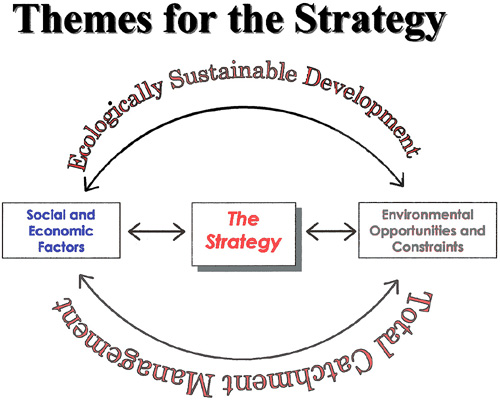
Figure 1: The Strategy Themes
GATHERING DATA FOR THE STRATEGY
The basis of preparing any strategy or study is to gather good, accurate and relevant data about the land and community being studied. Without this the strategy will be flawed. It is not the intention to go into a lot of detail about data gathering and survey techniques. The basic data requirements for carrying out a rural strategy will be outlined.
The data requirements can be broken into three broad headings:
physical characteristics and hazards;
Physical constraints should include slope, drainage, flooding, land stability and areas of land degradation and salinity as well as bushfire prone areas. This information should be mapped, preferably on a Geographic Information System (GIS). The maps can then be combined to form constraint maps to aid in the analysis of the land to prepare strategies.
Land use information is one of the most important and is linked to lot size and ownership. These should be mapped and if possible entered into a GIS to enable cross tabulation of land use by lot size. Land cover and quality refers to vegetation, agricultural suitability and rural capability. This too should be mapped. It is important to distinguish between agricultural suitability and rural capability mapping. Agricultural suitability mapping refers to the physical, social and economic issues for the location of agricultural land and should be only used on a Shire-wide basis, not for single properties. Rural capability mapping refers to the physical capabilities of land to sustain certain uses such as cropping, grazing and the construction of buildings and roads. Thus, it can be used for single properties.
The social and economic data relates to the population size and age as well as social indicators and trends. The make up of the local economy and the contribution of the various components is also important. Other data about the local community is also useful in the preparation of strategies.
CONSULTING WITH THE COMMUNITY
Community consultation or Stakeholder consultation, as it is sometimes called, is a very important component of developing any planning strategy. In fact, it is a compulsory component for the development and preparation of Local Environmental Plans, Regional Environmental Plans and Development Control Plans in New South Wales. To be effective, Community consultation must go beyond the requirements of the Environmental Planning and Assessment Act, which is to place a document on Exhibition once it has been prepared. Nowadays all too often the Community is wanting to be involved in the preparation of the document, not just commenting on it.
PREPARING THE STRATEGY
The process of preparing a planning document for rural land begins with the preparation of a strategy. Once the strategy has been prepared and exhibited, then the detailed planning documents are prepared. The first steps in preparing a strategy is to form an advisory group which has representatives of the Council, both elected representatives and staff from the planning and other appropriate Departments, Government Departments, land owners and local environmental representatives as well as members of the local community. This steering or advisory group should be formed prior to the commencement of work on the strategies and they will be used as a reference group as the documentation is being prepared. It is important for there to be an exchange of issues and aspirations for the project at the first meeting. It is also necessary for the relevant Government agencies to explain the application of the relevant natural resources policy to the local area and for them to be flexible in its application.
One very important component of preparing a strategy is the preparation, by the advisory group and/or community workshop participants of a detailed analysis of the area's liabilities, assets, needs and dreams (LAND). This should be done in the beginning of the process at the first advisory group meeting or workshop. It will allow for the refinement and prioritisation of issues and the development of objectives and appropriate strategies, action plans and responsibility areas. It is very important that areas of responsibility be put against the action plan and that the Strategy becomes a living document, and one that can be implementable.
Once the data that has been gathered has been analysed, synthesised and reviewed by the advisory group, then the detailed work on the preparation of strategies occurs. This can be done in many ways using a workshop technique and detailed strategic planning techniques or a loose gathering of a small group of representatives, who will carry out the preparation of the work. The workshops can be with the advisory group or with the community by invitation / advertisement. It is important to keep a database of names and addresses and to encourage people to add names to it after the workshop. There is no right or wrong way to prepare a strategy and the strategic planning model used will be dependant upon the makeup of the advisory group, as well as the budget and timeframe. The strategy should also outline the various proposed landuse designations for the area, as this is one of the major issues that people will wish to look at when the documentation is placed on public exhibition.
The strategy should also have recommendations for actions that have a statutory makeup, that is, they can be dealt with by zoning ordinance / planning scheme process, as well as non-statutory mechanisms, such as ways that the Council or Government Departments can influence the local economy, other areas of expertise and knowledge that can be used for the specifics of the case.
THE EXHIBITION
It is important when planning for rural areas that the exhibition is as wide ranging and reaches as many people as possible. Rural areas are generally disparate and more spatially spread out than urban areas and people cannot get to the exhibition points as easily. The exhibition should be a combination of a static display and information forums. The static display should be in the Council chambers as well as the library and mobile library if one exists. The information forums are a mechanism where the community is invited to come and view the details of the proposal during a four hour period in the late afternoon and early evening. This is also very important for fringe metropolitan areas where the members of the community may not work in the area and therefore will not arrive home until after 6 or 7pm at night. The use of the Internet is a growing area of technology that can be used to display exhibition material and the entire draft strategies because it allows people to view the documentation as and when they wish.
One of the benefits of having an advisory group which is lead through the process is that during the exhibition the members of the advisory group can be spokespersons and speakers for the process and will allow the matter to be discussed more fully in the general community, as the members of the advisory group who are community representatives, would be asked to discuss the matter with their groups and organisations to which they belong. This allows for a greater deal of issue discussion and the matter to be disseminated to community. The people who are on the advisory group generally are community leaders and have respect in the community, and if they are believers of the process, then the matters can be dealt with in a much easier and more effective manner.
IMPLEMENTING THE STRATEGY
The implementation of the strategy is perhaps the most important component of it. Once it has been adopted by the Council, it should, as soon as possible be implemented. The land use component is the one that is of most interest to the community and also is the easiest to do from a Council operational aspect.
The preparation of the zoning ordinance / planning scheme will also be the most important for the ratepayers of the Council area, as it will have the most impact on them directly. The zoning ordinance / planning scheme preparation should also be done in consultation with the advisory group. This too can take various formats depending on the timeframe and budget. These can range from a second round of workshops to having the advisory group review the draft document that has been prepared by staff. The exhibition of the zoning ordinance / planning scheme should be easier and less controversial because the Strategy outlined the land use designations and the zoning ordinance / planning scheme is confirming that. This is not to say that there will not be any problems with the zoning ordinance / planning scheme, just that some of the issues will have been ironed out. The advisory group will, once again help to spread the correct message to the community during the exhibition as with the strategy.
It is also important to keep advising the community about the progress of the strategy implementation. If a community workshop was held, the names and addresses of the participants will be used. The important thing is to keep them regularly informed about the process. If not, they will loose interest in the matter and it is likely not to be accepted. This is more important for the longer term, non-statutory recommendations.
CONCLUSION
Rural land is an important part of Australia's landscape but is one that is taken for granted by the community. People have different attitudes and perceptions about it.
We are coming to a point where the good agricultural land that is used for the production of food and fibre is being consumed for housing - both urban and rural residential. This is causing conflict and a loss of the land for good.
Strategic Planning is necessary for the planning of rural land in Australia because there is a need to conserve the resource. A strategy can be used to undertake this planning. It is important to prepare them with the community. Any strategy for rural land should be backed up by good data that should include survey of land use and other issues. It should also have a future zoning component and be implemented as quickly as possible to retain and maintain the enthusiasm of the community. After all, it is they who the strategies are being prepared for.
The preparation of strategies for rural land will enable us to achieve
a balance between the desires for living in a rural environment, the need
for productive agricultural land to be preserved and appropriate environmental
protection. This way we can grow food and grow houses in a sustainable
manner.
BIBLIOGRAPHY
Australian Bureau of Statistics (1996) Australian Agriculture and the Environment, ABS, Canberra
Australian Bureau of Statistics (1996) Australians and the Environment, ABS Canberra
Australian Bureau of Statistics (1997) NSW Regional Statistics, ABS, Canberra.
Australian Bureau of Statistics (1998) 1998 Year Book Australia, ABS, Canberra
Australian Bureau of Statistics (1999) Australian Demographic Statistics, December Quarter, www.abs.gov.au,
Budge, T. and Sinclair, I.W. (1998) Rural Australia: Change, Decline and New Directions - How Urbanisation Killed Crocodile Dundee, Paper presented to the American Planners Association Conference, Boston, April, 1998
Daniels, T. and Bower, D (1997) Holding Our Ground - Protecting America's Farms and Farmland, Island Press, Washington.
NSW Agriculture (1998) Strategic Plan for Sustainable Agriculture - Sydney Region, NSW Agriculture, Orange.
George, D. and Brouwer, D. (1996) Nature Conservation on Farms, NSW Agriculture, Maitland.
Nix, N. (1978) Availability of Land for Energy. Cropping Australia. Alcohol Fuels Conference, Sydney.
Nix, N. (1988) Australia's Natural Resources, in How many More Australians, Day, L.H. & Rowland, D.T. Longman, Cheshire.
Sinclair, I.W. (1999) Growth Management and Agricultural Land Paper presented to UNSW Planning Law and Practice Short Course, Kensington.
State of the Environment Advisory Council (1996) Australia State of the Environment 1996, CSIRO Publishing, Melbourne.
Wollondilly Shire Council (1993) Wollondilly Agricultural Lands Study, Wollondilly Council, Picton.
Wollondilly Shire Council (1996) Review of Rural Land Report, Wollondilly Shire Council, Picton.
World Resources Institute / United Nations Environment and Development
Program (1994) World Resources 1994-95, Oxford University Press,
New York
Copyright 2000 By Author
Ian Sinclair
Principal Consultant, EDGE Land Planning, Australia
www.ruralplanning.com.au