
|
|
|||
|
Cooperative Transit Planning in a Congested Suburban Corridor:
|
||
| Mary R. Lupa, AICP; Leanne Redden, AICP and Sidney E. Weseman | |||
| Session: Sunday April 16, 2000 | Author Info | ||
The Northwest Corridor Transit Feasibility Study addresses transportation need in the job-rich northwest suburbs of the Chicagoland area. This project began in late 1997 and is coming to a close in spring of 2000. This study, an exploration of possible transit options for a suburban corridor, is being sponsored by a unique partnership including the Regional Transportation Authority, the Illinois State Toll Highway Authority, and five suburban municipalities. This report introduces the corridor study with an overview of the participants, each of whom shared the challenges and potential pitfalls of working on an ambitious, high profile project with a full complement of regional partners. Innovative sponsorship arrangements and regional cooperation will be stressed.
Introduction
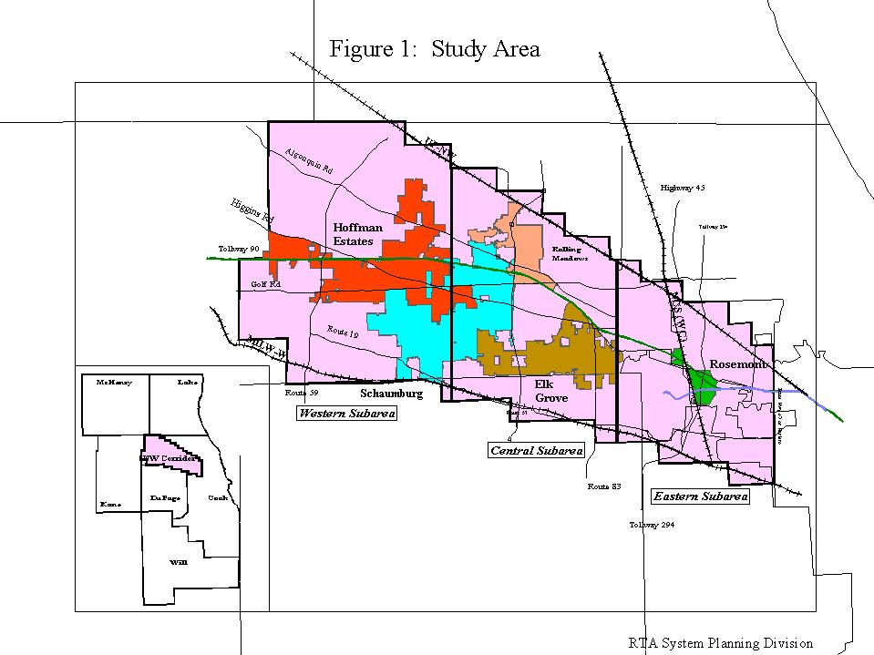
The Northwest Corridor is an area in the northwest portion of Cook County in Northeastern Illinois as shown in Figure 1. In addition to O'Hare International Airport, this area contains major employment, retail, and entertainment concentrations. These activity centers have developed over the past 20 years along the area's expressways and arterial roadways. Growth in economic activity has been accompanied by increasing congestion levels on the area's roadways.
[FIGURE 1] Study Area
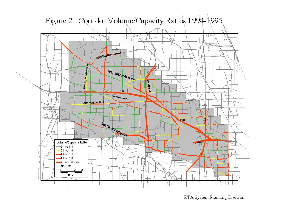
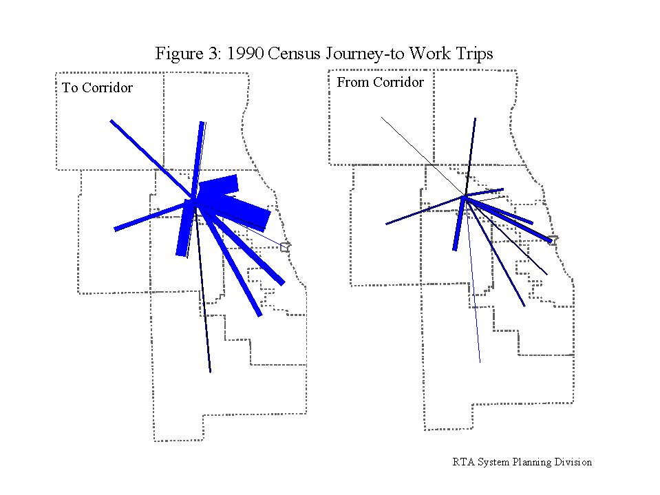
The Northwest Corridor project came to the forefront of the region largely because of local input. Mayors in the key suburban municipalities that make up Northwest Cook County began to voice their concerns about the symptoms of the transportation problem in their corridor ? these include traffic congestion, and the difficulty in attracting and retaining employees, both professional and industrial. The degree of traffic congestion in the corridor in 1994, expressed as the ratio of roadway volume to capacity, is shown in Figure 2. The roads in the corridor, particularly the I-90 toll highway, suffer from traffic congestion for many hours of the typical day. Furthermore the corridor is a big regional employer with over 500,000 workers in 1995, many of whom travel in from outside the corridor. The number of employees is expected to increase in future years, with employment growth outpacing population growth. The patterns of workers moving in and out of the corridor in 1990 are shown in Figure 3. Figures 2 and 3 represent only a fraction of the data and information that was collected and processed regarding transportation in the Northwest Corridor. The regional goal of moving people, especially workers, efficiently and cheaply was not being met.
[FIGURE 2] Corridor Volume/Capacity Ratios 1994?1995
[FIGURE 3]
1990 Census Journey-to-Work Trips
GENESIS OF THE STUDY
The Northwest Corridor Transit Feasibility Study was commissioned to investigate the transportation problem in the corridor. The objectives of the study were to provide a cooperative exploration and assessment of corridor transportation options and their consequences; to identify a small set of feasible cost-effective transportation improvement alternatives; and to provide information to support subsequent decisions on transportation improvements.
The Regional Transportation Authority, the Illinois State Toll Highway Authority, and the municipalities of Schaumburg, Elk Grove Village, Hoffman Estates, Rolling Meadows, and Rosemont agreed to jointly undertake the study. Study Policy and Technical Committees were established to guide the study and the partners agreed to share the costs of consulting services. The RTA and the ISTHA agreed to pay 1/3 each towards the cost of the study, with the five municipalities paying 1/15 each.
The service boards of the commuter rail, heavy rail, and bus providers in the region participated in the study as did the Illinois Department of Transportation, the City of Chicago Department of Transportation, the U.S. Department of Transportation, and the planning organizations in the region, Chicago Area Transportation Study (the MPO) and the Northeastern Illinois Planning Commission. A brief description of the seven central players in the study follows.
The Regional Transportation Authority The Illinois State Legislature created the Regional Transportation Authority (RTA) in 1974 to provide public transportation in the six county area surrounding Chicago in northeastern Illinois. These counties are Cook, DuPage, Kane, Lake, McHenry and Will, covering about 3,700 square miles. As a result of a 1983 legislative reorganization, the RTA is exclusively responsible for fiscal planning and policy oversight of public transportation in northeastern Illinois. The actual operation of transit services is the responsibility of the RTA's Service Boards -- the Chicago Transit Authority (CTA), the Commuter Rail Division (Metra), and the Suburban Bus Division (Pace). Virtually all public funding for transit -- for both operational and capital purposes -- flows through the RTA. Funds that the RTA does not directly distribute, such as farebox revenues, are still subject to RTA budgetary controls. The total 1998 operating budget for the RTA and its Service Boards is approximately $1.3 billion.
The Illinois State Toll Highway Authority The Illinois State Toll Highway Authority (ISTHA) is comprised of four limited-access Interstate highways that serve the northeastern Illinois Region connecting with the Illinois Department of Transportation Interstate freeway system. The ISTHA system serves both as a major radial and commuter system for the Chicago Metropolitan area and as component parts of the northern Illinois Interstate Highway System, which is heavily utilized by automobile and commercial traffic. The overall system consists of 273.5 miles of roadway with over 90 interchanges and 535 bridges, supporting more than 15 million vehicle miles of travel daily. This entire system is funded 100% from user fees, i.e. tolls, concessions or revenue bonds based on future toll receipts. This system is being maintained at high standards of design and operation.
Schaumburg Schaumburg, an 'edge city' with a population of 74,000 and an employment of 73,000, is located principally in northwest Cook County and approximately 30 miles from downtown Chicago. In this municipality of approximately 19 square miles, retail trade is the dominant industry with the municipality containing over 10.2 million square feet of commercial space including 65 shopping centers. Retail sales in Schaumburg generated over $29.5 million in 1996, a figure exceeded in Illinois only by Chicago.
Rosemont Rosemont, with a population of 4,000 and an employment of 23,000, is located in Cook County on the northwest edge of the City of Chicago approximately 15 miles from downtown Chicago. This municipality, adjacent to O'Hare International Airport, is the site of several of the region's largest hotel, office and exhibition facilities and of the Rosemont Horizon Stadium, which has a seating capacity of 18,500. The CTA Blue Line service from Chicago to O'Hare Airport has a major station within the municipality. Many of Rosemont's significant locational and developmental assets are due to its proximity to O'Hare. Most employment is in the categories of retail trade, wholesale trade, and business and financial services
Elk Grove Village Elk Grove Village, with a population of 34,000 and an employment of 80,000, and encompassing approximately 11 square miles, is located principally in Cook County northwest of O'Hare Airport and approximately 22 miles from downtown Chicago. Annually over 90 million pounds of freight travel into and out of the industrial park of this municipality, which has 80 million square feet under roof. Manufacturing, service, and warehousing/distribution are the key types of industry. Elk Grove Village is unique in the percentage of small businesses that make up total businesses. In 1994, 72% of employers operated with 25 persons or less.
Rolling Meadows Rolling Meadows, with a 1990 population of 23,000 and a 1990 employment of 27,000, is located principally in northwest Cook County approximately 30 miles from downtown Chicago. Rolling Meadows, which is approximately 5 square miles, features manufacturing, retail, business and financial services, contract construction, communications and utilities.
ORGANIZATION AND TIME FRAME OF THE STUDY
A number of opportunities existed with regard to the timing of the Northwest Corridor Study. It was crucial that the study be executed on an aggressive schedule so that its results could be considered in the design of the ISTHA I-90 capacity enhancements, particularly as several of the transit alternatives were being tested with guideways in the I-90 right-of-way. Timely completion of the Northwest Corridor Transit Feasibility Study would preserve options for all decision makers.
The project approach was organized as follows:
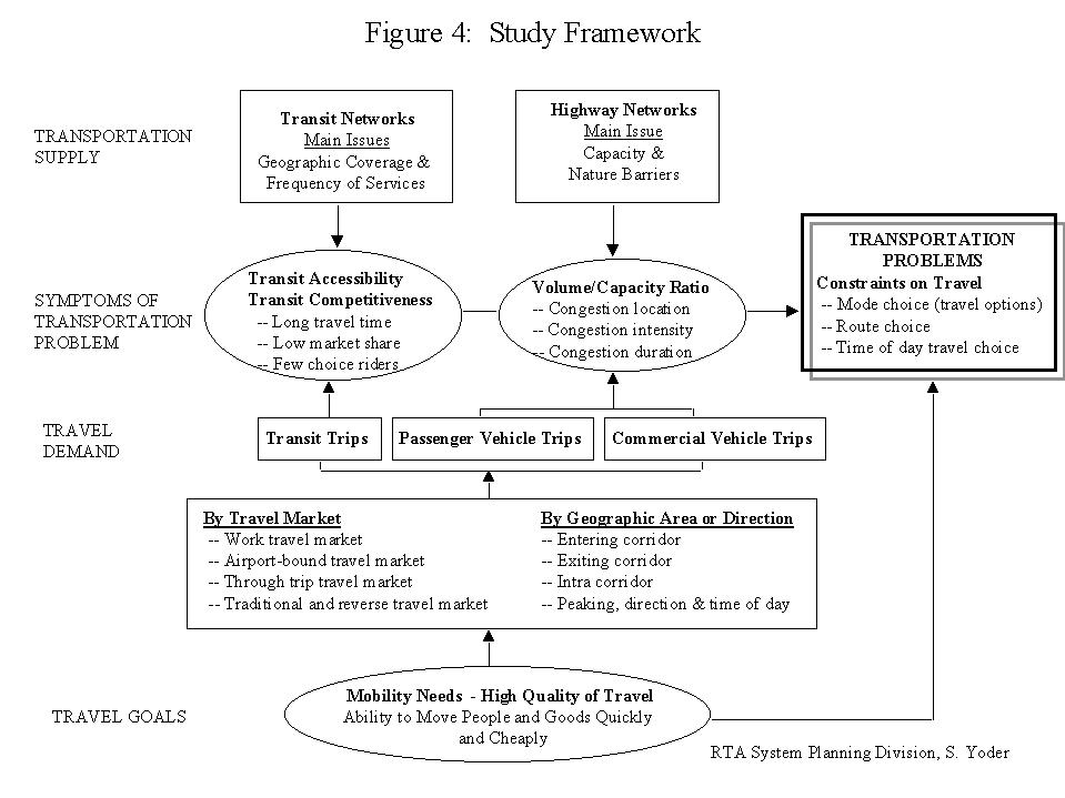
RTA provided the project management as well as the travel demand forecasting work component of the Northwest Corridor Transit Feasibility Study. A consultant, retained for the remaining set of tasks, did the following:evaluate the corridor travel market; develop a problem statement; generate transportation alternatives that address the problem statement; conduct an initial screening to narrow the alternative for detailed analysis; conduct a detailed analysis of the remaining alternatives; and make recommendations.
[FIGURE 4] Study Framework
All of the data that was examined for the market analysis showed a facet of the same transportation problem that the municipalities had identified.
TRANSPORTATION PROBLEM
The transportation problem that characterized the Northwest Corridor of Cook can be summarized as substantial constraints on mobility in the corridor ? constraints on mode choice, route choice, and the time of day of travel. These problems can be addressed by improving access to jobs and major activity centers in the corridor; and by expanding the transit options for those traveling to destinations west of O'Hare Airport. Eight transportation alternatives were tested as mobility boosters in the corridor. These were:
As of the spring of 2000, the Northwest
Corridor Transit Feasibility Study was coming to a close. The evaluation
of the eight transportation alternatives was complete. The study
technical and policy committees began the process of reviewing the draft
recommendations. The conference session that is a companion to this report
will explore the challenges of working through a complex, multi-layered
project with a group of diverse participants. The financial, transportation
planning, and strategic planning partnerships that characterized the Northwest
Corridor Transit Feasibility Study will be explored. One thing that
all parties have agreed upon is that the finest result of the study was
the enhancement of the cooperative relationship that characterized the
regional participants.
Copyright 2000 By Authors
Mary R. Lupa, AICP
Senior Analyst
Regional Transportation Authority
181 West Madison Suite 1900
Chicago, IL 60602
312-917-0796
lupam@rtachicago.org
Mary has spent eight years in the technical area of transportation planning.
Leanne Redden, AICP
Director of Transportation
Village of Schaumburg
101 Schaumburg Court
Schaumburg, IL 60193-1899
847-923-3860
lredden@ci.schaumburg.il.us
Leanne has worked in Schaumburg, Illinois for the past nine years as the Transportation Planner, Senior Transportation Planner and was recently named as the Director of Transportation for that municipality.
Sidney E. Weseman
Manager, System Planning Division
Regional Transportation Authority
181 West Madison Suite 1900
Chicago, IL 60602
312-917-0760
wesemans@rtachicago.org
Sid has over 20 years of diverse experience in transportation planning with public agencies in Chicago.