
|
|
|||
|
The Development and Community Application of the Social Assets and Vulnerability Indicators (SAVI) Project |
||
| Karen Frederickson, Cynthia Cunningham, Paula J. Schwabe, and David Bodenhamer | |||
| Session: | Author Info | ||
Introduction
The Social Assets and Vulnerabilities Indicators Project (SAVI) was initiated in 1993 to develop a common repository of information on Indianapolis' community assets and vulnerabilities for use by human service and community planners. Although conceived initially as a limited data set to be distributed as static maps in hardcopy and digital format, it has evolved into a comprehensive, GIS-enabled database of mapped and tabular data on the Indianapolis MSA. The SAVI database now includes census, education, health, crime, welfare, and other statistical data, as well as information on social service agencies, religious organizations, libraries, health care facilities, and other community organizations. These data are aggregated to multiple aerial units, including census tract, block group, township, zipcode, school corporation, and county boundaries.
To keep the SAVI database flexible and robust, resources continue to be devoted to maintenance, processing of new data, archiving, and development of more efficient processes, including the possibility of migration to new platforms if required.
A primary goal of the SAVI project is to make the data and the analyses derived from them a central tool of community development in Central Indiana. Data are essential but not sufficient unless accompanied by analyses that educate and engage citizens and organizations in the tasks of community development. The City of Indianapolis' applications of the SAVI database to planning and human service projects demonstrate the potential for generating meaningful analysis and valuable collaborations from SAVI.
Project Initiation
The United Way/Community Service Council (UW/CSC) in partnership with The Polis Center at IUPUI undertook the development of the SAVI database in 1994 with funding from the Indianapolis' Coalition for Human Services Planning.
During the project initiation phase, a steering committee of analysts from a variety of local agencies convened to provide recommendations on the content, design, governance and funding of the project. Agencies represented included The City of Indianapolis, Marion County Health and Hospital Corporation, Indiana Youth Institute, The Indianapolis Police Department, Indianapolis Public Schools, Information and Referral Network, Inc., Indiana Department of Workforce Development, Community Centers of Indianapolis, Indianapolis-Marion County Public Library, Walker Information, Wishard Hospital, and Central Indiana Council on Aging.
Many of these organizations provided data to support a prototype database. In addition to providing their own datasets, the steering committee determined what other agencies should be approached for data. It was decided that data should be made available at little or no cost to users. GIS technology was identified as the means for demonstrating a mapped database that could be continually updated and combine information from a wide variety of sources.
The resulting SAVI prototype demonstrated the benefits of building an accessible community database and highlighted the power of GIS to display social demographics and assets in a graphic format to enhance the decision-making process. The project's funders and advisory groups subsequently supported SAVI's expansion beyond Marion County to the nine County MSA as well as the incorporation of historical data.
Project Development
While the first phase of the SAVI project was effective in establishing
interest and support in the SAVI concept of a community indicator database,
it has been critical in subsequent phases of the project to deliberately
address the long-term goals of
1) sustainable database maintenance and development
2) data distribution and web development
3) training and user group development
4) analysis and report generation and
5) community building.
Database Maintenance and Development
The SAVI database becomes increasingly large and complex with each quarterly update and the continued addition of new datasets and derivation of new data classifications and data aggregations (see Appendix A for a list of SAVI datasets and data classes). Key factors influencing sustainability of database development and maintenance include staff composition, relationships with source providers, data selection criteria, data documentation, and the development and application of adequate quality control procedures.
The original project team consisted of data analysts capable of identifying which datasets were of value for human service and community planning. It has been necessary to subsequently add GIS, database, and programming professionals to the project team for the design and implementation of a sustainable database and data delivery system. These additional team members establish and implement procedures for data collection, documentation, processing, quality control, storage, and delivery. The teaming of technical and analytical staff has been essential in producing a data product that is technically sustainable while continuing to produce data that is analytically useful.
Good working relationships with data source providers are critical for database maintenance and expansion. Data source providers are often concerned that client confidentiality may be jeopardized through either data handling or the way that the data is displayed. In response to these concerns as well as the project partners' desire to institutionalize the project, memorandums of understanding and confidentiality agreements are established with data source providers, stating how data will be collected, processed, and displayed. An acceptable use policy has also been established for web access to SAVI data.
Because significant resources are required to develop and maintain a well-documented, reliable SAVI dataset, it is necessary to carefully evaluate potential additions to the SAVI database. Data selection criteria have been established to facilitate the selection of new datasets for incorporation into SAVI. Factors considered when evaluating a new dataset include data content, expressed user interest, frequency and long-term availability of updates, reliability of data source provider, breadth of geographic coverage, data quality, availability and completeness of data documentation, redundancy with other existing or potential databases, and data confidentiality. The benefits of developing a new dataset are weighed against the costs relative to other datasets being considered for incorporation. This said, the importance of accommodating linkage to other datasets, whether a neighborhood or regional dataset, is well recognized. Indeed, it is the ultimate goal of the project to allow users to upload and/or geocode their own data for use with the main SAVI social indicators basemap. This will be possible through the web data delivery and access system currently under development.
Data documentation is another an important element of the SAVI project, for internal data processing and quality control purposes as well as for the representation of complex data consistently and in lay terms for the public. Many of the human service organizations that contribute data to the SAVI project either do not have the resources or the expertise to thoroughly document their database. While ideally "metadata", or data about data, is produced by the data source provider, the SAVI project team currently documents both the source data as well as the processed data for most SAVI datasets. Metadata is reviewed with source providers to ensure accuracy and to train source providers to potentially take over metadata maintenance.
While the SAVI project does not accept responsibility for errors and inaccuracies in source data, the project does make a reasonable attempt to identify problems with source data. For all the processed SAVI datasets, both automated and manual quality control procedures are implemented for thorough data review. The project initially releases processed data as beta releases to data source providers and advanced users for review prior to release to the public.
Data Distribution and Web Development
A primary concern for the SAVI project is how to transfer data in an efficient, effective, and meaningful manner to SAVI users. The technological sophistication of our intended audiences was initially overestimated, a circumstance that is being corrected through technical improvements, more training, and a shift to web delivery and the development of a more intuitive interface.
While the goal of the project is to make data as publicly accessible and user-friendly as possible, there are limitations, including varying user skill levels and data confidentiality, that make it necessary to create different levels of user access. The SAVI database can be accessed at many sites and at varying levels of capability. The first level of access to SAVI data is through the SAVI Web page (http://www.savi.org) which provides interactive query and display of the SAVI database, as well as sample maps and background information on the SAVI project. The data available through this Web page grow each quarter, as additional portions of the SAVI database are released.The second level of access is through public access sites that have been established at libraries throughout central Indiana. These access sites contain selected data of interest to a wide audience. The sites are interactive with data presented as maps or in tables. These sites have trained staff members who can help users access the data. Depending on the needs of the user, staff members may refer users to enhanced access sites.
A third level of access is through enhanced access sites, which have the full set of SAVI data and support the performance of more in-depth analysis than possible at the other access sites. These sites have analysts who attend regular SAVI training and can assist the user in understanding and using some of the more complex data. A fourth level of access is through The Polis Center where researchers can work directly with staff to have custom analysis done against the raw data for their particular research needs.
The future of the SAVI data delivery system is with the web. Although this medium does not currently accommodate all the data available in the database, it offers the best and most flexible means to deliver data to the highest and most varied number of users. The interactive mapping allows individual users to create maps on the fly, drawing upon the data that fit their needs. As mentioned earlier, the system will be developed with on-line geo-referencing capabilities, such as address matching, that facilitate user-generated data to be linked to SAVI.
SAVI's move to the web is being supported in part by the award of a 1999 Telecommunications Opportunities Program (TOP) grant by the Department of Commerce. The funded SAVI Community Connections Project (SCCP) will develop an interactive, Internet-based interface that uses geographic information system (GIS) technology to give Indianapolis's inner city community-based organizations (CBOs) increased access to information about their communities and improved opportunities for training and learning. SCCP will allow them to quantify areas of need in their communities and will ultimately improve their ability to bring additional resources into the community.
Training and User Group Development
The depth and breadth of the SAVI database makes it necessary to provide regular and structured user training and support. Indeed, training is essential for making SAVI a primary tool for community development. Training is of two types: technical and analytical. Users must know how to navigate the system for best effect, but more important, they must be knowledgeable about analytical methods and strategies. The challenge is to teach users to analyze the data to understand community issues to test and evaluate proposed solutions. Both technical and analytical training require continued development of teaching modules and skilled trainers, as well as some pilot initiatives with selected organizations to help them use SAVI information in their strategic planning. The modules are both published and placed on-line to serve the demands of continuing education.
Access site training sessions are held at the end of each SAVI project quarter, during which newly processed data are reviewed, including any related quality control and data reliability issues. Additionally, training modules are prepared to teach access sites new skills and applications of the database. Users are encouraged to discuss how they apply SAVI and any obstacles they face. These meetings are also used to identify what new data the SAVI user community would like to incorporate into the database.
Analysis and Report Generation
SAVI will gain value and support if it helps people understand the issues confronting the Indianapolis MSA. A good way to accomplish this objective is through a regular series of reports, derived from the data, which describe and analyze these issues. The reports, while drawing upon the skills of professional analysts, must be cogent, timely, responsive, and accessible to the educated public and especially to community decision-makers.
Information dissemination occurs in the form of analysis and technical reports, quarterly newsletters, brochures, web announcements, and press releases.
Community-Building Agenda
It is recognized that reports alone will not be sufficient to help SAVI realize its potential as a community-building tool. They may be used to facilitate strategic discussion of options available to the community, including but not limited to asset development and evaluation and assessment. These discussions may be public or deliberative and may be structured as roundtables, intra- or interagency sessions, or civic forums, among other forms. In the upcoming phase of the SAVI project, the United Way/Community Service Council and The Polis Center plan to convene stakeholders at least semi-annually around an issue of central importance to the community, using SAVI both as a data source and an analytical tool. SAVI can also be used to model various scenarios and test proposed solutions.
As a part of IUPUI, The Polis Center has been able to engage several academic departments within the University and other Universities in utilizing the SAVI database for applied research and classroom applications. Among these is a proposed research project by the University of Chicago, Pritzer School of Medicine to study birth outcomes of mothers who used licit and illicit substances while pregnant and whether there is a correlation between use of these substances and the social demographic vulnerabilities present in the area where they live.
Many neighborhood groups and social service agencies use the SAVI database for grant applications and needs assessments. The Polis Center recently used SAVI data to assist the Community Centers of Indianapolis in an evaluation of their service areas.
The United Way of Central Indiana (UWCI) uses the SAVI database on a regular basis to determine the geographic trends of needs in the community. UWCI also uses the SAVI database to portray the distribution of human services programs and facilities and to easily identify neighborhoods that are lacking community assets such as Boys and Girls Clubs, YMCAs and YWCAs and parks. The database of assets also helps in determining which agencies can collaborate in achieving a community outcome. In short, the SAVI database is an important tool in figuring out the best way to target donations given through United Way.
The City of Indianapolis was one of the original access sites and has continued to support the project by providing low or no cost access to quality analysis of the database to the public. As discussed in the next section, the City uses SAVI extensively for its community planning purposes.
Planning Applications
The City of Indianapolis, as one of the original partners in the SAVI project, envisioned several uses for the information available in the database. The Planning Division of the Department of Metropolitan Development houses the SAVI database for the City. The Planning division uses SAVI extensively in two areas of its work plans. First, it uses SAVI as a data source for background information in many planning processes. Secondly, it uses it as a supplemental data source for smaller, everyday tasks.
Use in Planning Processes
Two examples of where the SAVI data has been used in major planning processes or projects are the City's recent Empowerment Zone Application and the preparation of the 2000-2004 Consolidated Plan. Following are descriptions of the projects and how SAVI was used within them.
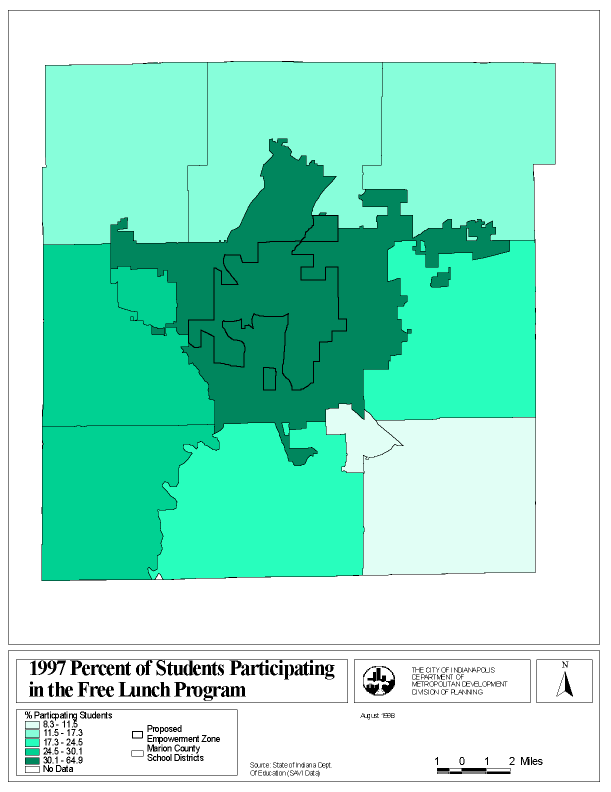
Empowerment Zone Application. The City of Indianapolis, along with its Enterprise Community, applied for a federal Empowerment Zone Designation in October of 1998. The application emerged from a four-month strategic planning process that involved over 300 people representing citizens, government, business, education, and labor. It was built upon the City's 1994 strategic plan for the Indianapolis Enterprise Community, Building Bridges to Better Neighborhoods, which focused on four main areas: Capital and Enterprise Development, Workforce Development, Crime/Public Safety, and Housing. The EZ plan brought each of these areas up to date, and also added two additional issues: education/technology and tax incentives/developable sites.
The EZ application included a Community Assessment which addressed each of the above areas along with ten year goals and strategies, a two year, project specific implementation plan, a tax incentive utilization plan, a developable site plan, a governance plan, a community performance assessment, an outline of the strategic planning process, and leveraging information. If granted, the Empowerment Zone designation would have brought in approximately $20 million of federal money and secured almost $677 million in leveraging funds.
SAVI provided much of the demographic information included in the application, including Census data (basic demographics, poverty and income), education data, crime data and community asset data. The following maps (Map A and Map B ) are examples of the type of information used in the application that came from the SAVI database.
5 Year Consolidated Plan. The City of Indianapolis submitted its most recent Five Year Consolidated plan to the Department of Housing and Urban Development in November of 1999. This document serves not only as a required application for Community Development Block Grant (CDBG), Home Investment Partnership (HOME) Emergency Shelter Grant (ESG), and Housing Opportunities for Persons with AIDS (HOPWA) dollars, but also as the City's five year strategy for housing and community development.
The plan was built around two major themes as previously outlined in a 1998 local community plan entitled A Housing Strategy for Indianapolis: Directions, Recommendations and Actions: Building Strong Neighborhoods: A Revitalization Strategy, and Family Self Sufficiency: An Anti-Poverty/Homeless Strategy. To support these themes, the City committed to preserving and increasing homeownership opportunities through homeowner repair and direct homeownership financial assistance, increasing the supply of affordable rental housing through construction and vouchers, eliminating unsafe buildings and sites, supporting capital and enterprise development, and supporting neighborhood empowerment. Also included was supporting special housing needs through construction of appropriate units and aiding supportive service activities to help the very low income household improve their economic status.
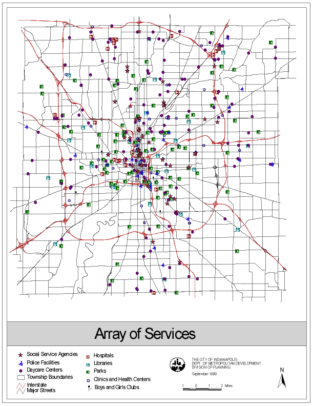
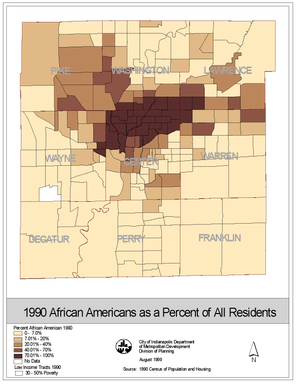
SAVI data was used extensively for different portions of this plan, including population data, public facilities, and housing supply information. (Map C and Map D are examples of where SAVI was used in the plan)
Use as a Supplemental Data Source in Smaller Projects
SAVI is also used extensively in smaller projects, including detailed analyses and grant applications and customer requests. The following text describes Home Mortgage Disclosure Act Data analysis and one of the grant applications in which SAVI data was used.
Home Mortgage Disclosure Act Data Analysis. Available in SAVI, Home Mortgage Disclosure Act (HMDA) data is a valuable source of information on banks' lending patterns by demographics. The City, along with the Polis Center, has run several different analyses on HMDA data to understand the movement of loans within the Indianapolis community.
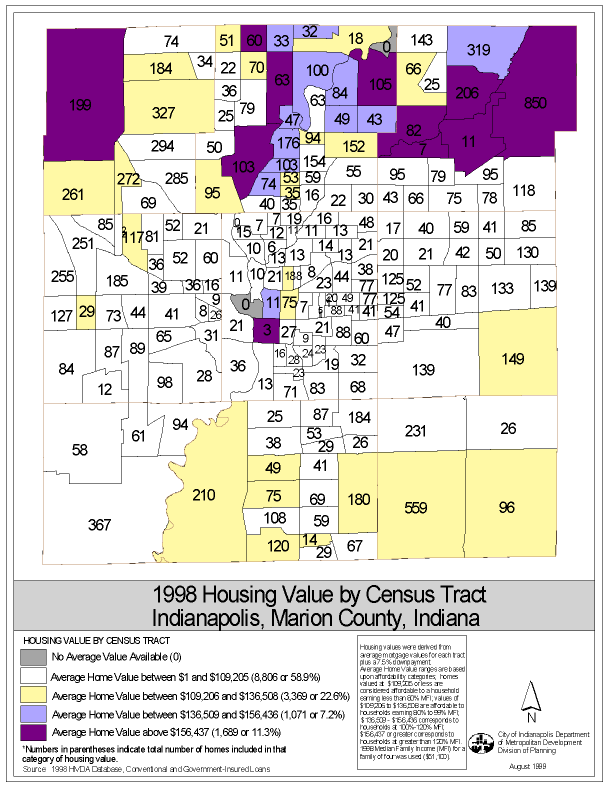
The analysis that is pictured in Map E helps planners discern where affordable housing is being bought (and sold) in Indianapolis, and where the higher end housing is located around the city. It indicates the number of loans and the average value of loans originated in each per census tract. This way we can get an idea of the "hottest" area in the city for home purchase, and can also determine where the affordable homes are. While Map E indicates 1998 data, the Planning Division runs this analysis yearly to determine trends in the housing market.
Grant Applications, Customer Requests. SAVI data is used extensively in filling customer requests, especially in requests that originate in not-for-profit social service agencies throughout the Indianapolis area. There have been several occasions in which governmental and not-for-profit agencies have used SAVI information in grant applications for specific county wide or geographically based programs. Some of the grants assisted were transportation based, while others focused on social service programs.
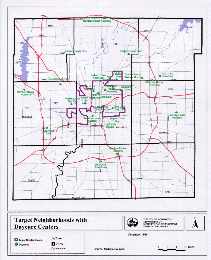
The following Map (Map F) was included in an application for a Welfare to Work grant that was sought by the City of Indianapolis' Office of Mobility Management. The grant was funded by the U.S. Department of Transportation's Federal Transit Administration, and was designed to provide transportation services in urban, suburban and rural areas to assist welfare recipients and low income individuals access to employment opportunities. It included site specific information on employment centers, existing transportation opportunities for low income citizens, and demographic information to determine where the program would be most effective.
SAVI was used in this application to gather the demographic information (income and density of welfare recipients per census tract) as well as to site some community assets, such as daycare centers.
Conclusions
The addition of the SAVI data to the Planning Division's information
resources has not only facilitated the inventory phase of planning processes,
but it has improved the breadth and quality of information available for
citizens. The fact that it is updated quarterly allows for time-series
analyses and enables planning staff to make decisions and recommendations
based on up to date information.
APPENDIX A
Database content
The SAVI database is updated on a quarterly basis.
Indianapolis MSA
Reference geography (e.g., census tract, township, streets, county,
streams), current
U.S. Census, 1990
Education, 1980 and1990-1999
Housing Coming,1992-1997
Welfare, 1997-1999
Community Assets (point locations), current
Marion County Only
Birth,1988-1998
Death,1988-1998
Fetal Death,1988-1998
Uniform Crime Report, 1995-Quarter 2, 1999
Indianapolis Police Department (IPD) District, Marion County Crime,
1993-1998
Marion County Juvenile Justice, 1992-1998
Copyright 2000 By Authors
Karen Frederickson, Cynthia Cunningham, Paula J. Schwabe, and David Bodenhamer